
Please fill out the form below to access our Translation Options Hotsheet:
If you imagine your younger self thinking of what you wanted to be when you were older, didn’t it seem like such a daunting task? What do I want to spend the rest of my life doing? Do I choose something that pays well or something that I enjoy? A safe 9-5 office job or take a risk and work for myself? Will it be too stressful? Will I be any good? What if I’m not successful. Can I change my decision later? These are all possible questions that you ask yourself.
No matter what we do, kids are always going to have these worries about career choices. That’s what we do, we worry about the unknown. However, if you were more exposed to different career options and pathways at a younger age, you might not be so worried about thinking you have 5 choices and must make yourself fit the mould; teacher, doctor, vet, fireman, lawyer, you know the drill. Instead we want to expose kids to a multitude of careers that not even their parents may know exist. That is the exciting thing. There is something for everyone and we just have to let kids know that they don’t ‘have’ to fit the mould. They can make their own path, we just have to give them the tools and the exposure to different industries not showcased in the public eye. As they say, ‘knowledge is power’.
Here at Get Kids into Survey, our mission is to bring young people into the exciting world of survey and geospatial through pioneering content and engaging experiences. To expose them to the diverse opportunities within our industry from a young age.
Enjoy a short introduction video by The Survey Association!

However, when you do get to the stage when you are that bit older and making steps towards becoming an adult, what do you do?
We have put together this document with the help of Sarah Clark a Surveying Recruiter from Australia, James Gibbs owner of Geospatial Jobs, the Royal Institution of Chartered Surveyors (RICS), Katie Holt at Chartered Institution of Civil Engineering Surveyors (CICES) with their research ‘State of Geospatial Engineering Education’, Antony Pritchard UK Surveyor at Storm Geomatics, and Ryan Swingley Surveyor from the USA. Collaborating our knowledge to try and show you the different entry ways into this industry, from the choices you make at school, to getting your first job.
Becoming a Surveyor in the UK
Understanding the Basics
To become a surveyor you’ll usually need a professional qualification approved by the Royal Institution of Chartered Surveyors (RICS), CICES, ABET or equivalent. In the UK you do not have to be a member of either however, this may limit what you can do and who you can work for. Full members of RICS call themselves chartered surveyors and are generally more property based. In comparison to being a member of CICES which is more engineering surveying and commercial management. If this is the route you would like to go down, that can be followed by applying to be a chartered engineer through the Engineering Council.
To become a Chartered Surveyor whether you’ve just come out of university or you’ve been working with a company, are required to take an Assessment of Professional Competence. There is another assessment to take before this to become an Associate which is the entry-level RICS qualification and offers the chance to progress to full chartered status. More information on becoming chartered here. There are multiple levels to CICES membership, with the two main professional grades being Technical member (TCInstCES) and Member (MCInstCES). For a more detailed descriptions of all the options look here.
Lower School Options (pre 18): Usually to get into higher education you’ll need 2 to 3 A levels, or equivalent. Subject choice is important even at this early stage and can help with the understandings of the basics. Good choices include:
- Maths- with a maths extension if you can.
- Economics
- Geography
- Geology
- Physics
Design Engineer Construct! is a secondary school aimed accredited learning programme by Class of your Own. The result is having young people with real-world practical experience and employability skills. So being involved in projects like this will definitely help build up your skills if this is something your school can get behind. If you are a teacher and interested in applying this to your school then check out this link.
 University: “If the university lifestyle appeals to you and you want to study a subject leading to a fast-paced, high-tech career, then a surveying-related degree could be ideal for you.
There are more than 300 courses in the UK alone, so there’s a surveying course suited for you – no matter where you want to study or what your career ambitions are” (RICS).
They could include:
- surveying
- business studies
- economics
- estate management
- land and property development
Taking an accredited degree can be the first step to becoming a surveyor. Whether that is undergraduate study or postgraduate. This is because the relevant organisations work in partnership with universities to ensure that the accredited degree courses are relevant to industry. So when studying, your qualification will be recognised by employers as the benchmark of quality. Find courses here: http://www.ricscourses.org/Course/# or https://www.cices.org/membership/about/courses/.
Apprenticeships (16 plus): You could do a chartered surveyor degree apprenticeship. Also the geospatial survey technician level 3. You will usually need 4 or 5 GCSEs at grades 9 to 4 (A* to C) and A levels, or equivalent, for a higher or degree apprenticeship. This will be partly studying in school and partly out getting hands on. Search opportunities on the Government website (UK).
There are two levels of apprenticeships. At age 16 you can study a level 3 course, and then at 18 can study for the level 5 or 6.
There is a level 6 option which is geospatial mapping and science specialist. This is equivalent to a Bachelors degree. Find out more here.
T-Levels (age 16)– Mike from RICS introduced the concept to us, where students can gain practical work experience whilst studying 14 key modules in college (20:80 split). Work placements are scattered between the college work, with three exams at the end of the second year. It has been developed in collaboration with industry employers and professional bodies, including RICS and CICES.
*Could your business help train the next generation of surveyors? To find out about the benefits of offering a T-Level work placement, visit the government’s website, or email Mike Cox at mcox@rics.org.
Work Progression: If you have a higher national diploma or foundation degree in surveying or construction, you may be able to work as a surveying technician, and take further training on the job to qualify as a professional surveyor, or to specialise into a specific field. This is similar to progressing and diversifying into your niche of preferred work.
Development scheme: You could get a postgraduate qualification through a graduate trainee scheme with a company to work for (through RICS or CICES which offer special schemes); The Survey School run by the TSA provides a great 2 year block release course as well as other short courses. Education is also available through distance learning with the University College of Estate Management.
Becoming a Surveyor in the USA
American Specific University Study– Taking a ABET (or similar) accredited course provides a great base. “We are a nonprofit, non-governmental agency that accredits programs in applied and natural science, computing, engineering and engineering technology. 
ABET accreditation provides assurance that a college or university program meets the quality standards of the profession for which that program prepares graduates.
We accredit programs, not institutions. We provide specialized accreditation for post-secondary programs within degree-granting institutions already recognized by national or regional institutional accreditation agencies or national education authorities worldwide.
Our accreditation is voluntary, and to date, 4,307 programs at 846 colleges and universities in 41 countries have received ABET accreditation. Over 100,000 students graduate from ABET-accredited programs each year, and millions of graduates have received degrees from ABET-accredited programs since 1932”.
Find courses here.
Becoming a Surveyor
Unlike other countries, each state in the US has different requirements for becoming a surveyor. Each state has their own licensing board which is often referred to as the Board of Registration. Education requirements and experience requirements vary state to state as well.
In Indiana (where our Brand Ambassador Ryan is from) for example you must have an associates degree with 27 credit hours in specific land surveying courses. You must work under the direct supervision of a Professional Surveyor (PS) for 2 years and then you can take the Surveyor Intern exam. Once that exam is passed there’s an additional 4 years working under a PS before you can sit for the PS exam. Once all of that has been completed you are able to practice on your own.
All states have some sort of combination of education and experience. Some require a Bachelor’s degree and 2 years of experience. A few states have a path to licensure where no education is required but you have to work under a PS for 10 years. For more information about the qualifications required by the respective states for designation as a Professional Surveyor, visit this site.
Becoming a Surveyor in Australia
 Australian TAFE Qualification: “Work with civil engineers, builders, project managers and architects in the design and construction of major projects such as commercial buildings, bridges, roads, dams, tunnels and railways. Civil Construction and Surveying courses offer students a chance to gain hands-on experience and apply their expertise in the construction industry.
TAFE NSW qualifications can lead to careers in a range of different industries and sectors from roads to mining to residential to defence”. Find out more here.
Australia Specific University Study: Attending University to obtain a degree (Associate, Bachelors or Bachelors with Honours) – the entry requirements and prerequisites differ in each state. Find more detail about each state and the courses available from this link.
Becoming a Surveyor Worldwide
Extra Curricular: Gaining work experience is one of the most important things you can do. Not only does this show how keen you are to learn the skills needed for the job, it also tells you if the career is what you expected, which at this point you could alter your career path to suit something that is more suited to you.
If work experience isn’t an option for you, volunteering certainly is. Volunteering not only looks good on your CV, but it helps you get a grounding and gaining life skills. It does not have to be within the industry, any volunteering is valuable.
There are a wide variety of sectors and routes to go down in this industry. Nicely demonstrated in this image:
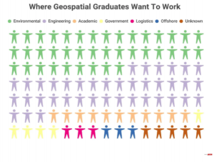
A great representation by Geospatial Jobs showing which sectors the Geospatial Graduates of today want to go into. There are so many options within each of these sectors too. Lots to explore and grow with as you gain more experience and opportunities. Further specialisation can be made with further qualifications for career progression.
Challenges in recruitment in the sector: It is clear from the ongoing needs of the construction industry that there will be a significant shortfall in the number of suitably qualified individuals to take up post in organisations working on the huge infrastructure projects that the UK will be embarking on over the next 10 to 20 years The shortfall in construction skills is mirrored in the supporting geospatial profession which provide the foundations to most of these projects so play a critical role.
“Both the University of East London and Newcastle University have seen a long-term trend of falling numbers of students applying to study specialist geospatial degree courses. The Design Engineer Construct! curriculum, which features geospatial engineering, has had its parity with GCSEs and A levels removed by the Department for Education, making it less viable for schools to offer”.
Solutions to the Challenges: The Industrial Strategy: Construction Sector Deal published in July 2018 refers to the investment of an additional £406m in maths, digital and technical education, helping to address the shortage of science, technology, engineering and maths (STEM) skills. Which will be a big boost to the geospatial industry as we are very much included in this and the digital aspect.
Kids often do not have the understanding of what the geospatial industry is. With a lack of applied activities in school even though they are learning the content. The major problem is that teachers, parents and the children do not know the career options available or the possible high earnings for those professionals that come with it. As mentioned previously the Design Engineer Construct is here to try and teach more about the opportunities within the industry to secondary school ages. In lower years Get Kids into Survey is trying to expose the industry in a fun way, including it in posters which are branching out into Q&A’s and lesson plans too. Schools are encouraged to have geospatial engineers and survey firms to come in to deliver assemblies and regularly engage with the kids. Lastly, the Adopt a School programme from Class of Your Own partners construction firms (including geospatial engineering businesses) with schools and offers site visit opportunities and hands-on demonstrations of geospatial equipment and software.
In the Geospatial Engineering Education report the Geospatial Commission are provided with a list of proposed changes and targets in order to help the industry progress. Some of these suggestions include: ensuring long term funding is available for more apprenticeship based learning, : Geospatial academia and research bodies are asked to work with industry and professional bodies to ensure opportunities are present to everyone, Geospatial academia and industry and professional bodies are asked to improve liaison with STEAM and geography teachers, and that careers information is available from a young age.
Advice for current students:
How do you ensure a job is right for you? “Knowing if a job is right for you is such a circumstantial question, I think. In my opinion, the most important thing is that you be interested in the core of the role. For me, it’s chatting with people/socialising, for surveyors, it may be geography, or math, or being outdoors. Surveying can see you in the middle of the bush, or on top of a 28-story high rise in the city, or hundreds of metres underground; this is great, because there’s a branch for almost everyone. But you have to be excited, and love what you do” -Sarah Clark
Katie Holt explains “There are lots of exciting career choices in surveying – you could be involved in construction and helping to make sure projects are built correctly, in the right place or you could be using drones, laser scanners and other instruments to produce plans and maps of areas. There are plenty of opportunities for varied work and travel within your country and overseas.”
Linking back to another blog by James Gibbs, he asked the question ‘What advice would you give to someone starting a geospatial career?’ in which five geospatial experts gave their advice. Some key messages that I took away from this were:
-Curiosity is key… ask those questions, dig deeper and make connections. The more you show genuine interest and willingness to learn the further you will go.
-Technology is advancing at a rapid rate, which leads to never ending opportunities where the only limit is your imagination! Especially in recent years the development of tools used in space, collecting data through environmental observations, navigation and communications.
-Don’t be afraid to question how and why things are done in a certain way. New ideas come from new perspectives, that might just happen to be you!
-Your first job doesn’t need to be your final job. You are free to follow your interests when different and new opportunities present themselves.
Useful Links:
https://nationalcareers.service.gov.uk/job-profiles/planning-and-development-surveyor
https://www.truity.com/career-profile/surveyor#
https://www.classofyourown.com/
http://www.buildingpeople.org.uk/
https://geospatialjobs.co.uk/articles/
‘State of Geospatial Engineering Education’ Submission to the Geospatial Commission September 2019.