

Please fill out the form below to access our Translation Options Hotsheet:
Surveying Monopoly has been created with one big vision: to bring the world of geospatial surveying into a household game that families around the world can play, enjoy and learn from together. Across the board, real surveying and geospatial organisations are represented by their own unique characters, places and technology, showcasing just how varied and exciting the profession can be.
But who are the characters taking their places on the board, and what do they tell us about the real world of surveying? It’s time to meet them! Through a quick-fire Q&A, we’ll discover the inspiration behind each character, their favourite surveying tools, what their organisation does, and even where in the world they’d most like to survey.
Let’s learn some more about GeoTek PR and their character Cotorra:
 🦜 Company name and location?
GeoTek PR LLC — San Juan, Puerto Rico. We’re a geospatial technology integrator and infrastructure platform serving Puerto Rico and the Caribbean. Think of us as the team that makes sure surveyors, engineers, and mappers across the islands have the best tools, the best network, and the support to use them.
🦜 What is your name and what inspired your design?
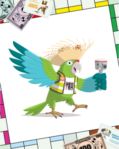
My name is Cotorra — named after the Puerto Rican Amazon (Amazona vittata), the island’s only native parrot and one of its most beloved symbols. I’m critically endangered in real life, which makes me a symbol of resilience — and that felt right for a company building something new in a market where nothing like it existed before.
I wear a pava — the traditional woven straw hat of Puerto Rico’s jíbaros, the hardworking country folk who shaped the island’s identity. My little friend perched on the brim is a Coquí — Puerto Rico’s tiny tree frog whose two-note call (co-KEE!) is the sound of the island at night. And in my claw? A Falcon X SLAM LiDAR scanner — the most advanced mobile scanning tool available in the Caribbean. I don’t go anywhere without it.
🦜 What tool would you never leave the office or field without?
The Falcon X. It’s a SLAM LiDAR scanner with a full GNSS receiver built right in — which means it knows exactly where it is on Earth while it’s scanning. Most scanners need an external GPS unit bolted on. Not the Falcon X. One device, centimeter-level accuracy, and it fits in one hand. I carry mine everywhere. As you can see.
🦜 Which square on the Surveying Monopoly board would your character most like to visit and why?
Remote Sensing Road — because that’s where the Cotorra feels most at home. Remote sensing is how we see the world without touching it: drones mapping coastlines, satellites tracking land changes, LiDAR beams painting invisible surfaces into 3D reality. GeoTek PR brings that technology to Puerto Rico and the Caribbean — and the Falcon X is our weapon of choice. Point it at a building, walk around it, and in minutes you have a complete 3D model accurate to within centimeters. No touching required. No days of setup. Just walk, scan, done. Also, I suspect there would be snacks there.
🦜 What is the coolest thing about surveying that kids might not know?
Here’s something most people never think about: when a hurricane hits Puerto Rico, when the ground shakes from an earthquake, when a flood swallows a road — before the engineers can plan, before the builders can rebuild, before anyone knows what was lost or where to start, surveyors show up first.
We’re the ones who go into the damage to measure what changed. Which roads shifted. Which bridges moved. Which hillsides are now somewhere they weren’t before. Without that information, nobody can safely rebuild anything.
After Hurricane Maria, after the 2020 Southcoast earthquakes — surveyors were in the field while the dust was still settling. Mapping. Measuring. Giving engineers the data they needed to start putting Puerto Rico back together.
That’s what we do here. And that’s why GeoTek PR exists — to make sure the people doing that work have the best tools on the island when it matters most.
🦜 How does your company help surveyors measure, map, or build the world around us?
GeoTek PR builds the geospatial infrastructure that Puerto Rico and the Caribbean run on. We distribute cutting-edge GNSS equipment and LiDAR scanners, and we operate GeoNET — our island-wide RTK correction network that gives surveyors centimeter-level GPS accuracy across all of Puerto Rico. When a surveyor in San Juan sets up their rover and gets a precise position in seconds, GeoNET is working in the background making that possible. We also train the people using these tools, so the technology actually gets used to its full potential.
🦜 If you could travel anywhere in the world to survey, where would you go?
Easy — the old city of San Juan, Puerto Rico. El Morro fortress, La Fortaleza, the cobblestone streets laid down 500 years ago. Most of it has never been fully scanned in 3D. Imagine capturing every stone, every wall, every cannon port in a centimeter-accurate point cloud — preserving it digitally for the next 500 years. That’s the kind of work that reminds you why this profession matters. Plus, I’d be home. And the mofongo is better there than anywhere else in the world!