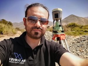
Introducing Edward Atoche from Lima, Peru:
 Where did you study? National University of San Marcos
What are the requirements to be a surveyor in your area? The requirements to be a surveyor in Peru are the following:
– Obtain a professional degree in an institute certified by SUNEDU.
– The professional surveying career lasts from 2 to 3 years.
How did you get into surveying? I am a geographer engineer specializing in geomatics, when I started my professional practice my cousin who is a cartographer gave me the opportunity to work with him, it was a rewarding and wonderful experience that helped me and encouraged me to continue working in topography, geodesy and photogrammetry.
If you are not a surveyor, what do you do? To teaching on topography issues and also sales of topographic equipment.
How long have you been in the industry? More than 15 years working in topography.
Are you part of any associations or organisations you would like us to mention? For more than 8 years I work in my company EA SURVEY where I provide topography, geodesy and photogrammetry services, as well as training for topography students.
I am also a member of the chapter of engineer geographers in the college of engineers of Peru.
Why do you want to be a GKiS Brand Ambassador? Because it seems to me a great initiative to make the surveying career known to children and young people, I always wanted to participate in this type of project and spread this interesting profession related to technology and innovation.
Why is it important for kids to know about surveying and the wider geospatial industry? Because it will allow children to know how this interesting career develops and how important it is for the development of certain activities in the world, developing motivation and interest in topography in children.
What are you going to do as an ambassador for GKiS? Support by publicizing this great initiative on social networks, visiting schools, participating in events and collaborating with GKIS in each of its new projects.
What are your hobbies? My hobby, apart from topics related to topography and geotechnologies, is soccer.
If you/your company had a GKiS character, what would it be? A boy with his helmet and his GNSS receiver in his other hand making an all-okay gesture.
What resource would you like to see next from GKiS? I would like some application to be developed where, in a didactic way and with a teaching methodology, the child is oriented on general topics of topography, geodesy and photogrammetry.
Anything else you want to add that you think our audience (surveyors, teachers, parents) would be interested in? A web platform with which all those involved in this great project can interact and thus develop courses, webinars and training.

