
Please fill out the form below to access our Translation Options Hotsheet:
 Where did you study? I studied Civil Engineering in El Salvador.
What are the requirements to be a surveyor in your area? Locally, Land Surveyors had been linked mostly to Civil Engineering. There was a degree on land surveying in the early 1900’s but with time it was abolished. Technical schools formed some generations of surveyors with the sole purpose of assisting civil engineers. At some point in history it was considered a repetitive task that anyone could perform.
With the introduction of electronic instruments and GNSS receivers in the early 90s some universities updated their equipment but surveying was never added as a career. Being one of the most technological careers, with a broader scope of applications, and an increasing demand for geospatial information, a new breed of surveyors needs to come along. It’s a challenge not just to bring kids into the career, but to get Universities to add Surveying and other Geospatial careers to their programs.
 How did you get into surveying? I got into surveying by accident. I was studying electronic engineering right after high school, in the early 1990s, one day I was listening to a professor ask us to imagine electrons flowing. Suddenly, I thought I wouldn’t see myself doing this for the next 20 years. So the next semester I switched to Civil Engineering and got a job at a construction site just to be sure I was not making a wrong decision. I was working hard drafting and calculating when one day a muddy guy came along and told me, do you want to know where the data came from?
Saying yes to that request is a decision I’ll never regret, I found myself standing behind an old and dusty Wild T-16, looking through its telescope and I found what I would like to be the rest of my life. One thing led to another and in a matter of time ended up working for a local Leica reseller, selling and training customers creating relations with universities. Next I was hired by Carlson Software to do basically the same but on a larger scale in a huge chunk of Latin America and the never ending learning process has not stopped since day one. Now I run a small business, I’m a local reseller, and I’m devoted to discovering new ways of helping surveyors and their customers get the results they want.
How long have you been in the industry? 25 years and counting
Are you part of any associations or organisations you would like us to mention? Rumbo GNSS SA de CV
 Why do you want to be a GKiS Brand Ambassador? Surveying is a highly technical and self rewarding occupation, we use all the toys that appear on the movies, GPS receivers, lasers, satellite images, 3D models etc. Kids need to add to their career option of being a Land Surveyor for sure.
Whilst traveling I found that the perception about Surveyors is totally wrong, and many students lack excitement, passion for the industry, and have a “it is what it is” attitude that prevails and we must change that by exposing how fascinating, rewarding and fun the profession is. In a world where isolation and social distance may be around for a while, and jobs may be hard to find, land surveying gives the opportunity to get them self employed and provide their services to a variety of customers and industries. We need kids eager to go out and believe that they can change the world, so they have to know that everything they dream of doing will begin and end with a survey.
Why is it important for kids to know about surveying and the wider geospatial industry? We are heading to a world that will be communicating faster and faster, where assets, utilities, and services will be increasingly monitored remotely, the main question about all of them will be “where are they?” So we need to encourage kids to be the ones who do those tasks and attract them into surveying. This generation is already connected, technology savvy, that if we add the location ingredient to their knowledge we can create the next breed of professionals that will produce that highly demanded geospatial information.
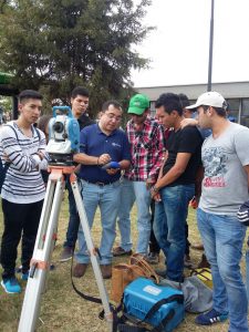
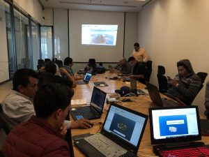
 What are you going to do as an ambassador for GKiS? First I would translate the posters you have in English, into Spanish. Plus with your help I could post information in Spanish onto your media channels. Locally I can approach high schools to show kids what they can do with surveying hardware and mapping software and how the information produced is relatable to other careers. I have contacts in universities region wide which is helpful, I may look for government offices that create youth development programs in order to expose surveying as a career path. We could approach agencies that demand surveyors services to incentivise surveying tuition in schools, as well as aid agencies like USAID, plus vocational aid funds etc for scholarships to promote surveyors.
In latin America there’s a high rate of school dropouts, due to poverty and delinquency, and surveying can be a way for them to become independent and productive individuals. I would look for tech companies to help teachers get updated and schools to obtain hardware and software for their tuition. I also have industry contacts that I can ask to do lectures online telling what they do, how they do it and why they love to keep on doing it!
What are your hobbies? I love my Labrador dog, training her entertains me, I used to travel for work but do it also for leisure. I’m a football fan (Go Cowboys!), like aerial photography, going outdoors, and I think I’m a decent cook!
If you/your company had a GKiS character, what would it be? Aztecs, Mayas and Incas did great cities, roads, and aqueducts at impossible places. They were great surveyors for sure, I would pick a Jaguar since all of them have it in common.
 What poster or resource would you like to see next from GKiS? Latin America is diverse, so I would love to see a poster representing different ethnicities doing surveying tasks, different landscapes and lot of infrastructure that can be made so we can portray: highway and railway constructions, river dams, bridges, the continent is rich in mineral resources so you can include gold, coal stockpiles, reservoirs underground, ruins hidden underneath the jungle, vast agricultural areas that can be surveyed by drone; my ideas are endless.
Anything else you want to add that you think our audience (surveyors, teachers, parents) would be interested in? The world is a small wonderful marble, and a lot of people today just see it through the eyes of others. Surveying is a chance to go out there, explore it, learn from it, preserve it and improve the conditions of the ones who live on it.