
Please fill out the form below to access our Translation Options Hotsheet:
 Let us introduce you to our latest Brand Ambassador; Assumpta Jebichii, a final year student pursuing Geospatial Information Science at Maseno University, Kenya. Assumpta is dedicated, detail oriented and an approachable expert of GIS, remote sensing and survey, who attributes success to outmost discipline and determination. She has excelled in areas such as Geospatial software management (ArcGIS and AutoCAD civil 3D), data collection and research.
She is passionate about making a change in her community and the world in general by using GIS as a tool in solving real world problems, hence providing long-term solutions. “I believe that GIS and Survey is a powerful tool and it should be embraced by all.”
Assumpta is a a member of Women in GIS, GIS chapter (Maseno University), PASAMU (Planning association of students of Maseno University) and a former GIS/Survey Intern of the Kenya National Highways Authority (KeNHA).
Do you attend Career Fairs?
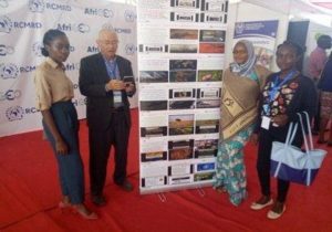
The annual RIC AfriGEO symposium at the Regional Centre for Mapping of resource for Development (RCMRD).
I got the opportunity to attend this conference that brought together decision makers, Geospatial engineers, surveyors and students across the globe. It was aimed at showcasing the importance of spatial data in finding solutions in sectors such as, governance, land administration, healthcare planning, utilities etc.
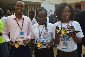
LAKE BASIN INNOVATION AND INVESTMENT WEEK(LBIIW)
Kid’s Hackathon
This conference was guided by the theme, “Promoting innovation for sustainable development”. One of the core activities that I got to volunteer on was the Kids hackathon session, whereby kids from the lake region were being empowered on how to make toys and the use of robotics and also on how they can use their talents to bring solutions.
What is the requirement to be a surveyor in Kenya?
Under the Constitution of Kenya for someone to be able to practice surveying fully as a career, he/she must be licensed and should be a full member of ISK (Institution of Surveyors of Kenya) or he/she should work under a licensed surveyor.
How did you get into surveying?
I love maps because they do speak in a unique way. Maps can convey information in a way that no human eye can see, through interpretation and visualization. My passion for space and environment saw me take Geospatial information science and surveying as a career, because it gives me an opportunity to map out phenomena that have spatial characteristics and also to discern spatial relationships that do exist between features and why these relations happened.
I have grown my career through immense support and guidance from my lecturers and my mentors who are in the same industry, who have constantly empowered and mentored me to be where I am today.
How long have you been in the industry?
I have been in the Geospatial and survey industry for 1 year and half.
What Associations and Organisations are you apart of?
- Maseno University
- Women in GIS
- PASAMU(Planning association of students of Maseno University)
- GIS chapter(Maseno University)
Why do you want to be a GKIS Ambassador?
Get Kids into survey is a platform that instils core career values to the younger generation by empowering and mentoring them. I would like to be an Ambassador of this organization so that I can be a change to the younger kids. I would like to encourage and produce Geospatial engineers and surveyors from this generation and also from the disadvantaged groups in the society.
Why is it important for Kids to know Surveying and the wider Geospatial industry?
Geospatial information science and Surveying is a human interactive discipline that puts into consideration the opinions and the need of the community through Participatory GIS (PGIS).
It is important for kids to know Surveying and GIS because it will shape them to be key players, decision makers and critical thinkers in solving problems that are felt in the contemporary world by providing long term solutions by the use of spatial data.
Through this, they will also get to have a greater understanding on planet earth and on the importance of conserving the natural environment by use of maps and spatial data as a platform of making critical decisions pertaining the same.
What are you going to do as an ambassador for Get Kids into Survey (GKIS)?
As a Get Kids into Survey ambassador, I plan to engage all primary school and secondary school children in my community. I would like to be a change by empowering and mentoring them on core career values especially on what Geospatial Information Science and survey entails.
I believe that out of this, many young children will feel empowered by guiding them on the importance of using their God given talents effectively and on how to make wise career choices when the right time comes.
What are your hobbies?
- Travelling to new places
- Reading a book
- Cooking
- Environmental conservation
If you could choose a Get Kids into Survey character, what would it be?
The character would be a Bear representing a Geospatial analyst. The character will represent the day to day roles of a geospatial analyst, who uses GPS for spatial data collection and maps for representing features.
What posters and resources would you like to see next from Get Kids into Survey (GKIS)?
- GeoSquad
- Utilities poster
- Forestry posters
- Crime scene investigation posters
Anything else you would like to mention?
“The future of our nations and the next generation is our key responsibility. A nation that invests and takes care of its children and their welfare is set to prosper”.