
Please fill out the form below to access our Translation Options Hotsheet:
Welcoming Ekpor Jephta our latest Brand Ambassadors covering Southern Nigeria, Rivers State, Bayelsa State, Akwa Ibom and Cross River State (Africa):
 How did you get into surveying? My journey into the geospatial industry began with a curiosity about how maps help us understand and solve real-world problems. While studying Surveying and Geomatics, I discovered that geospatial technologies go far beyond mapping, they influence environmental management, disaster response, urban planning, infrastructure development, and community decision-making. What started as academic interest evolved into a mission to make geospatial knowledge accessible to more young people, particularly in underserved communities. Today, I combine GIS, GeoAI, technology, education, and community engagement to help others discover the opportunities within the profession.
What are your plans as a Brand Ambassador? My goal is to expand geospatial awareness among young people across Nigeria and Africa by introducing surveying and GIS to students long before they make career choices.
As a Get Kids Into Survey Ambassador, I plan to:
Organize school outreach visits and GIS Day activities.
Introduce students to surveying, mapping, GIS, drones, and Earth observation.
Partner with teachers and schools to integrate geospatial awareness into STEM education.
Distribute and promote Get Kids Into Survey educational resources.
Create engaging social media content highlighting geospatial careers.
Build connections between students, universities, and geospatial professionals.
Support the development of future surveyors and geospatial innovators throughout Africa.
Tell us a bit about what you do: I am a Surveyor, GIS Analyst, GeoAI Advocate, Creative Strategist, and youth development champion based in Nigeria.
I currently serve as Partnership Advisor for FIG Young Surveyors Network VCSP and have contributed to international geospatial initiatives including the 4th African Young Surveyors Meeting (Kenya) and the 10th FIG Young Surveyors Conference (South Africa, 2026).
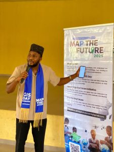
I founded Map the Future, a geospatial outreach initiative that introduces secondary school students to GIS, mapping, Earth observation, and spatial thinking. Since launching the initiative, I have worked with schools, students, and educators to increase awareness of geospatial careers and demonstrate how maps can solve challenges such as flooding, waste management, environmental degradation, and urban development.
Professionally, I work across GIS, spatial analysis, GeoAI, remote sensing, digital innovation, community engagement, and technology education. I am passionate about building the next generation of African geospatial leaders.
Anything else you’d like to add? One of my strongest beliefs is that many children never become surveyors simply because they are never exposed to the profession early enough. Through Map the Future, I have seen students become excited about mapping their schools, communities, and environments once they understand the impact of geospatial technologies.Before now I have visited more than 15 schools, and reached over 12,000 school children and made impact, But with Get kids into Survey, at map the future we will be able to do more.