

Please fill out the form below to access our Translation Options Hotsheet:
Welcoming Brand Ambassador Aisha Namuyanja from Kampala and surrounding areas, Uganda, Africa. Let’s learn some more about her:
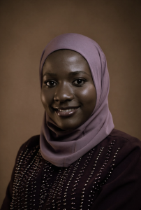
How did you get into surveying? Geomatics and Land Surveying was my first choice when joining university, although it was not a childhood dream. During the COVID lockdown, a conversation with my uncle, who worked at the Survey School in Entebbe, introduced me to the profession and its opportunities. When I started university, I realised that even many of my course mates had entered the programme with limited knowledge of what surveying actually involved; some had originally hoped to pursue other engineering fields. This made me appreciate how easily young people can overlook surveying simply because they have not been exposed to it.
Initially, I was attracted by the practical opportunities and stability I associated with the profession. However, internships, fieldwork and experiences across different parts of Uganda gradually changed my perspective. I discovered the breadth of surveying and geomatics, from cadastral and engineering surveying to GIS and spatial analysis.
My final-year research, using GIS and the SWAT modelling framework to investigate sediment yield response to rainfall variability, deepened my interest in the analytical side of geospatial science. I realised that geospatial technology was not simply about measuring and mapping places; it could help us understand complex environmental and societal
challenges and contribute to practical solutions.
What are your plans as a Brand Ambassador? As a Brand Ambassador, I plan to introduce young people to surveying and geospatial careers by sharing my own journey and showing them what the profession looks like beyond traditional field surveying. I would do this by participating in school career events and careers fairs where possible, giving short talks about the different pathways within surveying and geomatics, and using real examples from my experience in GIS, mapping, land management and environmental applications. I would also promote GKiS resources and activities through my professional and social-media networks, and encourage schools, students and other young people I engage with to explore the opportunities available in the profession. Through these activities, I hope to help address the lack of awareness that I experienced myself and encourage more young people, particularly girls, to consider geospatial careers.
Tell us a bit about what you do: I am a Land Surveying and Geomatics graduate with a growing focus on GIS, geospatial data and environmental applications. My experience has included field mapping, spatial data collection and validation, GIS analysis, land information management and supporting community-based land registration and land-use planning activities. I have also worked with geospatial technologies to explore environmental problems, including using GIS and the SWAT modelling framework for my undergraduate research. I enjoy seeing how spatial data can move from field observations and measurements into maps, analysis and information that can support better decisions about land, communities and the environment.
Anything else you’d like to add? I believe early exposure can make a real difference. Simple career talks, demonstrations of surveying equipment, examples of how maps and spatial data are used, and opportunities to meet young professionals can help students connect what they learn in school with real careers. I would especially like to see more girls introduced to the profession early, so that surveying and geospatial science are considered alongside the more familiar STEM career options.