

Please fill out the form below to access our Translation Options Hotsheet:
Surveying Monopoly has been created with one big vision: to bring the world of geospatial surveying into a household game that families around the world can play, enjoy and learn from together. Across the board, real surveying and geospatial organisations are represented by their own unique characters, places and technology, showcasing just how varied and exciting the profession can be.
But who are the characters taking their places on the board, and what do they tell us about the real world of surveying? It’s time to meet them! Through a quick-fire Q&A, we’ll discover the inspiration behind each character, their favourite surveying tools, what their organisation does, and even where in the world they’d most like to survey.
Let’s learn some more about Civil & Environmental Consultants and their character:
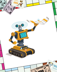 Company name and location? Civil & Environmental Consultants, Inc. – Chicago, IL (Corporate Office in Pittsburgh, PA)
What inspired your characters design? Our character has three of the best advances in technology, robotics, which is still evolving, GPS, the current staple, and remote sensing with drones, the game changer!
What tool would you never leave the office or field without? GPS has been the staple for a few decades, but remote sensing units are taking over as the “go to” tool of choice and robotics continue to provide new solutions.
Which square on the surveying Monopoly board would your character most like to visit and why? No doubt it would be field work surprise because every site we survey is different and often we are surprised when we show up at a site!
What is the coolest thing about surveying that kids might not know? The fact that our data and coordinate systems will consider the tectonic plate movements is mind blowing! Adding to that is the technology that continues to evolve which has been changing the profession.
How does your company help surveyors measure, map, or build the world around us? We try to provide and use the latest tools and technology to capture data for mapping. This now includes more types of remote sensing capabilities and advanced software and computers for processing the data.
If you could travel anywhere in the world to survey, where would you go? It would be Europe for the history, but maybe South Africa for the beautiful views and landscape!