

Please fill out the form below to access our Translation Options Hotsheet:
What does mining have to do with your phone? More than you might think…
Mining might not be the first topic that comes to mind when you’re looking for something new to teach children, but that’s exactly why it works so well.
From the phones in our pockets to the roads we travel on, mining is quietly behind so much of modern life. Yet most children never stop to think about where these materials come from, how they’re discovered, or the people and technology involved in bringing them to the surface.
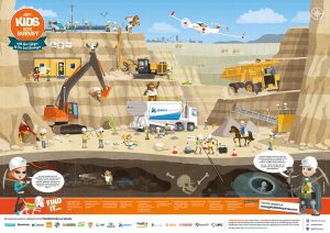
That’s where our Mining Poster comes in.
Designed to be colourful, engaging and packed with discovery, it invites children to explore how we find, measure and extract the materials that shape our world. Along the way, they’ll discover the role surveyors play in mapping mines, measuring underground spaces and helping projects operate safely and efficiently.
Whether you’re a parent looking for a fresh home-learning topic, a home educator planning a project, or a teacher searching for a real-world STEM resource, the Mining Poster offers countless opportunities to spark curiosity.
Why Children Find Mining So Fascinating
Mining naturally leads to some brilliant questions:
- How do people know where valuable minerals are underground?
- What does a mine actually look like beneath the surface?
- How do engineers and surveyors create maps underground?
- How do mining companies keep people safe?
- What materials in my house came from a mine?
These are the kinds of questions that encourage children to investigate, research and think critically about the world around them.
And often, one question leads to another.
Before long, a conversation about a mobile phone can become a lesson in geology, geography, maths, engineering, technology or environmental science.
Did You Know?
Did you know that many of the items you use every day contain materials that were once mined from the Earth?
Take a look around the room.
📱 Your phone
💻 Your laptop
🚲 Your bicycle
🏠 Your home
🔋 Your batteries
Mining isn’t something that happens somewhere else. It’s connected to almost everything around us.
That’s just one of the many discussion points explored in our accompanying Mining Q&A sheet, which is packed with questions designed to get children thinking, investigating and asking “why?”
One Question Leads to Another
One of the best things about teaching children through real-world topics is that learning rarely stops with the first question.
A conversation about mining might begin with:
“Where does the metal in my phone come from?”
Before long, children are exploring geology, discovering how minerals form over millions of years, learning how surveyors use drones, GPS and laser scanners to map the land, and discussing how mining companies work to protect wildlife, restore landscapes and source the materials needed for renewable energy. Modern life depends on mined materials, from smartphones and bicycles to wind turbines and electric vehicles, making mining an ideal starting point for exploring science, technology and sustainability.
That’s the beauty of curiosity.
One question becomes another.
Children begin making connections between subjects they might normally learn separately, discovering that geography, science, engineering, environmental studies and surveying all work together to solve real-world problems.
The Mining Poster isn’t designed to teach children everything there is to know about mining.
It’s designed to spark a conversation.
Because sometimes, one simple question is all it takes to inspire a lifetime of curiosity.
A Great Resource for Teachers, Parents and Home Educators
One of the things we love most about the Mining Poster is how many different directions the learning can take.
For teachers, it can support lessons in geography, STEM, natural resources, sustainability and careers.
For parents, it can spark conversations about how the modern world works and encourage children to look more closely at the objects they use every day.
For home educators, it can become the starting point for a wider project covering:
- Earth’s natural resources
- Mapping and geography
- Engineering and technology
- Sustainability and environmental responsibility
- Future careers and workplace skills
Rather than simply presenting facts, the poster encourages children to ask questions, investigate answers and make connections between subjects.
Where Does Surveying Fit In?
Before a mine can be built, expanded or monitored, someone needs to understand exactly what is happening above and below the ground.
That’s where surveyors come in.
Mining surveyors use a range of technologies to measure, map and monitor mining sites. Depending on the project, they may use GPS equipment, total stations, laser scanners, drones and specialist software to capture highly accurate data.
Some tools help surveyors map large areas of land, while others create detailed 3D models of tunnels, underground workings and mining infrastructure.
Laser scanners, for example, can collect millions of measurement points in a matter of minutes, helping create digital replicas of mines that can be explored and analysed on a computer. Drones can quickly survey large or difficult-to-access areas, while GPS technology helps ensure equipment, infrastructure and excavation work are positioned accurately.
These technologies help mining companies improve safety, monitor changes over time and make informed decisions about how a site is managed.
It’s a fascinating combination of technology, problem-solving and real-world application, and often surprises children who may not realise just how much innovation is involved in modern surveying.
Surveying in Action: When Accuracy Really Matters
The technology used in mining doesn’t just help companies work more efficiently. In some situations, it has helped save lives.
In 2010, 33 miners in Chile became trapped nearly 700 metres underground after a tunnel collapsed. For 69 days, the world watched and hoped. Engineers and surveyors relied on detailed measurements, mapping and precise drilling plans and measurements to locate the miners and guide rescue shafts with incredible accuracy. Remarkably, every miner was brought safely back to the surface.
A few years later, when a youth football team and their coach became trapped in a flooded cave system in Thailand, rescue teams again relied on detailed mapping, advanced 3D mapping tools, to better understand the underground environment and plan safe routes through the cave network.
These are dramatic examples, but they highlight something important: surveying isn’t just about collecting data. It’s about understanding places that can be difficult, dangerous or impossible to see with the naked eye.
Whether helping rescue teams navigate underground spaces or helping mining companies monitor changing conditions, surveyors provide the information that allows people to make safer decisions.
(At the end of the blog, you’ll find links to articles, videos and other sources to help you explore the topic in more depth.)
Did You Know?
Some laser scanners can capture millions of measurements in just a few minutes, creating highly detailed 3D models of mines and underground spaces.
That’s just one of the many technologies mining surveyors use to help keep operations safe and efficient.
Continue the Conversation
Why not ask your children:
- Which objects in your home might contain mined materials?
- What do you think happens before a mine is built?
- How would you create a map underground?
- What skills do you think people working in mining need?
You might be surprised by the answers.
Thank You to Our Sponsors
Like all Get Kids into Survey resources, the Mining Poster was only possible thanks to the support of organisations that believe in inspiring the next generation.
This poster was a truly international collaboration, bringing together supporters from the UK, USA and Australia who share a passion for education, outreach and raising awareness of surveying careers.
A huge thank you to:
3D Reshaper, Bowman Consulting, Carlson Software, GeoSLAM, Indiana Society of Professional Land Surveyors, Land Surveys, Laser Scanning Forum, Mini Map Makers, NEI, NSPS, Orica, Position Partners, SSOE Group, TopoDOT, RIEGL, UPG and Precise Observation Mining Solutions.
Their support has helped this resource reach classrooms, homes and outreach events around the world.
Continue the Adventure
If you’re ready to discover the hidden world beneath our feet, explore the Mining Poster online, download the accompanying Q&A sheet, or order a free printed poster from our shop (you’ll just need to cover the postage). We also have a homework project.
Who knows? One question about a mobile phone could lead to an adventure through geology, engineering, surveying and the incredible technology that helps us understand the world beneath our feet.
Further Reading:
Chile mine rescue (2010)
General overview (facts, dates, depth):
https://www.britannica.com/event/Chile-mine-rescue-of-2010
Drilling and rescue operation (“Rescue 33” story):
https://centerrock.com/about-us/job-stories/chilean-mine-rescue/
Rescue organisation reflection (10 years on):
https://www.mrsl.co.uk/about-us/knowledge-hub/rescue-33-chilean-miners-10-years
Thai cave rescue (2018)
Short piece on 3D scan of Tham Luang cave:
https://www.youtube.com/watch?v=Buda6f3n16g
Article about “The Rescue” documentary and 3D cave modelling:
https://www.documentary.org/column/rescue-recounts-2018-thailand-cave-mission
3D GIS visualisation of drilling options at Tham Luang:
https://mediaspace.esri.com/media/t/1_4h4d51u0
Modern mining surveying and safety tech
Surveying in the mining sector (laser scanning, drones, 3D models):
https://www.gim-international.com/content/article/surveying-in-the-mining-sector
Underground mine safety technologies in real-world scenarios:
https://www.identecsolutions.com/news/mining-safety-use-case-technologies-in-real-world-scenarios