In today’s Ambassador Spotlight, we discover a little more about our Brand Ambassador Timothy Hawthorne from Florida, USA.
If you are not a surveyor, what do you do? I am an associate professor of GIS at University of Central Florida in Orlando, Florida. I also am the Founding Director Citizen Science GIS and GeoBus.
How long have you been in the industry? I have been in the GIS/geospatial technology industry since 2003.
Are you part of any associations or organisations you would like us to mention? American Association of Geographers
Why do you want to be a GKiS Brand Ambassador? I believe in supporting and inspiring science’s next generation through hands-on educational opportunities. I am inspired by the global reach and positive energy of this GKiS community, and wanted to a part of the great work happening around the globe.
Why is it important for kids to know about surveying and the wider geospatial industry? So they recognize early that it is an in-demand, useful and highly rewarding career field in which they can thrive and contribute to the study of some of the most challenging environmental and social issues of our time. I was a student who entered my college years having no idea GIS and geography were a career option. I was hooked after my first Intro to the Power of Maps course in my sophomore year. Luckily I happened upon that course, it changed my trajectory and life path.
What are you going to do as an ambassador for GKiS? I am going to support global education and interest in geospatial technologies through our GeoBus program, the US’s first GeoBus to drive geospatial technologies in a repurposed 40 foot city bus with a solar-powered learning lab to K-12 schools and community centers. And I hope to work with others in the industry to develop a global GeoBus network to support our industry and science’s next generation.
What are your hobbies? In my spare time I love to travel, go to the beach and snorkel with my kids, wife and friends. I also love building Lego sets with my kids.
If you/your company had a GKiS character, what would it be? A drone operator for sure. We love flying drones, especially in coastal environments near islands and reefs.
What poster or resource would you like to see next from GKiS? A drone and surveying crew exploring reefs around the world with kids helping.
If you are interested in becoming a Sponsor or a Brand Ambassador for GKiS please follow the links provided.
Interesting Articles, February Edition
For more information about how to get involved with Get Kids into Survey please visit our Sponsorship Page or Brand Ambassador Page. If you have some interesting information that you think would fit in our future blogs please email them to learn@getkidsintosurvey.com
How you can use OS (Ordnance Survey) data to create a Tolkien-inspired map…
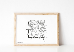
Have a go at creating your own ‘My Favourite Square’ project by following the instructions on this blog. You can even frame your finished piece!
A great activity to have a go at with your family. Have a go!
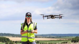
Dorchester rescue-drone pilot inspires young engineers
“Gemma Alcock runs Skybound Rescue which specialises in flying drones to save lives.
Now, she’s joined STEAM school (Science, Technology, Engineering, Arts and Mathematics) hosting a series of talks about robotics for children between 9-14 years old.” People like Gemma are so important for the future, helping inspire young people, especially as they can resonate with her about her experiences at school being similar.
Find out more about Gemma and her STEAM talks here (target age 9-14 years old) and why science does not have to be your forte in order to go into the technology industry: Steam School (steam-school.com)
How the geospatial industry is involved in the exciting self-drive future!
How are the connected and automated mobility (CAM) and automated driving systems (ADS) being developed? This highly complex and modern technology is soon going to be upon us, would you let technology take over your wheel? Learn more about the two possible approaches for this technology on the blog here.
Land Surveying Is A Great Profession, But Why Don’t Young People Know That?
“As any professional land surveyor knows, we are a part of a great profession. It offers tremendous variety, the chance to work outdoors, the opportunity to apply math and geography skills in the real world, and the satisfaction of contributing something of lasting value and importance.”
According to the Princeton Review, “. . . surveying job opportunities are expected to increase by more than 20 percent in the next ten years.” That’s a pretty solid reason to get into surveying from looking at that one statistic… find out the other reasons and how to go about it by visiting POB’s Blog here.
Our resources at GKiS may be beneficial too so please visit our Resources page for Posters, Lesson Plans, Quizzes, and Colouring Sheets!
We always knew we wanted to create a comic book for the industry and so in 2019 we set out to find ourselves the perfect writer for the job. We just so happened across Mat, our brilliant writer, teacher and friend. Mat Sullivan not only writes children’s novels but he also writes curriculum for teachers and is in fact a teacher himself in Manchester, England. Elly first presented Mat with the idea for the comic describing this future world, a world without surveyors; “I didn’t just want a story about surveyors and their jobs, I wanted a bit of a shock factor. We tend not to make change happen until we are faced with a disaster of sorts, and so if I could show this future world of despair, perhaps then people would really see how important surveyors and the geospatial industry is, and maybe just maybe start creating change for our future generation”. Mat took this idea and created what you know now as the Geo Squad comic book. If you haven’t read it yet, take a sneak peak at the first chapter here.
So, where’s it heading?
As some keen readers will know, the first three chapters were published in Point of Beginning and Civil Engineering Surveying Magazines. We also published the first chapter in the Nevada Traverse, CAL Surveyor and Florida Surveyor Magazine as well as National Geographic Kids UK, Australia and New Zealand.
We are saving the final two chapters for our comic book release on May 17th 2021.
Let’s set the scene…
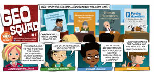
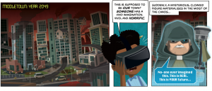
‘It’s Careers Day at West Park High School. Four friends stand in the sports hall, surrounded on all sides by stalls promoting some of the worst, most tedious, most brain-achingly boring jobs it’s possible for a human being to endure. The more of these stalls that the gang passes, the further their faces fall. Is this really what grown-up life has in store for them? Maddison Williams does not want to manage middle managers for a living; she’d much rather be a glacier-surfing, base-jumping shark wrangler! Setsuko Tanaka is on the lookout for the extra-terrestrial bio-science stand, but all she can find is someone advertising a job in human resources; a man so bored with his own life that he is sleeping at his table, open-mouthed and catching flies. Kwame Orumo wants to be an extreme archaeologist, and Miles Darwood has his sights set on the drone racing leagues, but all the foursome can see are paths to lives behind beige desks, wearing beige pants, drinking beige tea…
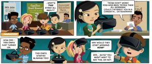
…That is, until they spot something strange in the corner of the hall: a table, unmanned, with no signs and no information, upon which lies four strange-looking headsets and nothing more. Intrigued, the friends approach, lifting up and inspecting these out-of-place objects. The gloomy guy on the Photocopier Technicians stand informs the group that people have been trying the headsets all day, and they don’t work. But, just as he starts to talk to them about the most boring job on Earth, the headsets suddenly flash into life. As the gang inspect the visors, turning them over in their hands and peering inside, they begin to wonder why these strange pieces of tech would start working now, just as they picked them up. Wonder soon turns to intrigue; intrigue becomes an irresistible curiosity, and before you know it, all four are wearing the mysterious headsets.
What they see shocks them more than the science skeleton sat at the GymClean Sweat Removal company stand. They see Middletown, their town, thirty years into the future – and it’s an awful sight to behold. Derelict towers collapse onto each other like drunken dominos. Cracked and twisted roads weave dangerously over, around, and even through crumbling buildings. Giant cracks and cavernous craters in the concrete streets threaten to swallow civilians whole, and the churning red sky above is filled with thick, choking smog.
This must be a figment of someone’s twisted imagination, right? The gang convince themselves that the awful images they are seeing can’t be real… until a strange, cloaked figure suddenly appears to tell them that what they are seeing is no-one’s imagined atrocity; it is real.
The comic revolves around a group of school kids turned super-surveyors called the GeoSquad. We wanted to highlight the importance of surveyors, so what better way than showing what a world would be like WITHOUT them in it!?! This way GeoSquad go on multiple adventures applying themselves to different roles in order to save their city. Surveyors are the heroes of our story with all different types and jobs demonstrated.
Have a read to find out more when it gets published in May. Sign up to our newsletter for updates
How can you get involved?
We require sponsors of Activity Pages for the Comic Book. We currently have a few spaces remaining, please see if any of these activities take your fancy. Or design your own game:
Find the Difference
Using sections of the exploration posters, subtly altered, this would encourage children to take a close reading of the posters and to really look at all the action and activity that is going
Totally True or Fully False!
Here, sponsor representatives in cartoon form would present their craziest stories from survey sites. Some would be true, some might be partly true but with a key detail dramatically altered, and some might be completely made up! This would be a good way to drive traffic back to the website, as the true/false reveals and the real stories could be hosted on there, perhaps with links to appropriate coverage of the unbelievable finds / events covered in the true stories.
Word search and Cryptic Clue Challenge
A traditional word search with a twist! The found words would stack up horizontally, one below the other, and one vertical line of characters from each word would spell out a special word – perhaps a password that allows the reader access to a protected page on the website where a special surveyor Easter egg (electronic special treat!) could be found. There would also be a glossary for the found words that would help young readers to better understand key geospatial terms.
Massive Measures
This page would comprise a multiple choice quiz based on heights, lengths, depths and other measures taken during extreme survey missions. The focus here would be on the wow factor in each example, showing how surveyors work at extremes, how vast the measurements that they take can be, and how they work all over the world, in all environments and conditions.
Mega Machines
On one side of this page would be a vertical row of images of survey vehicles / robots, and on the other side would be another vertical row of images of extreme / hazardous locations. They would all be mixed up, and the Last Surveyor would present the reader with the challenge to link the correct robot or vehicle with the setting in which it would be used. For example, a robotic serpent would be linked to an underwater setting; a drone would be used to survey the damage caused by forest fires, etc.
Keep an eye out for GeoSquads Character Profile blogs coming over the next few weeks. Learn more about the main stars of the comic, their likes, dislikes and a small introductory biography…
Location – London, United Kingdom (we also have offices in the US and Australia and we have staff and distributors in over 40 countries)
Why did you get involved in Get Kids into Survey? We love the idea of supporting kids with career exploration. Children are often only aware of a small number of occupations that they are exposed to on a daily basis, so learning about different types of career paths is great to spark interests and passions at an early age. At Senceive we wanted to help promote the surveying and monitoring industry to the next generation of young engineers and surveyors and help kids get excited and learn what our technology can do!
What do you do? At Senceive we design and manufacture wireless condition monitoring technology. Our sensors monitor railway track, buildings, tunnels, bridges and more for the slightest movements, and can send out alerts to engineers to check for potential problems or dangers. Our sensors are used in some of the world’s most complex and potentially dangerous environments. They are easy to install and once in place, surveyors and engineers can access movement data from their computers or tablets, so they don’t have to go to site. These sensors help keep the assets they are monitoring safe, as well as the people who use them.
How long have you been in the Survey Industry? Senceive Ltd was established in 2005 and pioneered the use of intelligent wireless condition monitoring in civil engineering and rail applications.
How did you get into the Industry? Highly skilled engineers started research in 2001 in the labs of University College London (UCL), one of the UK’s leading engineering universities. Ever since then we’ve been committed to providing surveyors with tools to gather vital information without having to go to site.
Funny Fact about the company/Sammy the spider– Spiders are found in every continent except Antarctica, just like our Senceive sensors.
Favourite piece of kit and why? Triaxial tilt sensor – this tiny sensor can be mounted in moments to any structure, at any angle and will tell its owner what is happening for the next 10 years or more.
Favourite Survey technique and why? Many laser-based survey methods are natural partners for our wireless monitoring technology. Automated total stations, for example, provide precise, absolute measurement from specific locations, whereas remote monitoring systems can cover wide areas providing a snapshot every few minutes.
Your website: www.senceive.com
How did you choose the character and what does he/she/it represent? Mean to you?
Sammy the spider has two types of webs (wireless platforms), his green (FlatMeshTM) webs collect movement data on his green webs once every minute! These sensors are super smart – they can send data to their neighbours, and the system will still work if some parts of it are damaged!
Sammy collects movement data on his blue (GeoWANTM) webs, his long-range webs – once every hour. These sensors can be really far away – up to 15 km – and they will still work to get Sammy the movement data that he needs!
With his webs, he is able to sense the smallest changes in his surroundings. If Sammy notices these movements are too big or not right, he is able to tell engineers so they can go check for potential dangers. Sammy is helping to keep the structures, transportation systems, and the people who use them safe.
We are thrilled to welcome John Hohol to the GKiS family. A wonderful man who does a lot of valuable work for the industry.
If you are not a surveyor, what do you do? President of the FIG Foundation (2003-present).
How long have you been in the industry? Since 1979. I have been a member of the national surveying association in the U.S. since 1979 (originally the American Congress on Surveying and Mapping- ACSM which merged with the National Society of Professional Surveyors-NSPS in 2012), I have also been involved in the International Federation of Surveyors (FIG) since 1981.
Are you part of any associations or organisations you would like us to mention? Honorary Member- International Federation of Surveyors (FIG), Life Fellow- National Society of Professional Surveyors (NSPS); Fellow- American Congress on Surveying and Mapping; Member- Wisconsin Society of Land Surveyors (WSLS)
Why do you want to be a GKiS Brand Ambassador? I am proud of my involvement in the creation and growth of young surveyor networks around the world and look forward to extending it to the youth of the world.
Why is it important for kids to know about surveying and the wider geospatial industry?Beyond being one of the oldest professions in the world the surveying and geospatial profession is also the foundation of everyday life. Those professionals were there first so the police, fire and ambulance first responders could find you. They determined boundaries, set roads, streets, subdivisions so we can live in our neighborhood, postal carriers deliver our mail and our governments provide important everyday services.
What are you going to do as an ambassador for GKiS? Continue to support and work with FIG, NSPS, young surveyors and other groups to open the eyes of young people to the amazing world of surveying.
What are your hobbies?Reading, traveling, helping others.
If you/your company had a GKiS character, what would it be? A detective, Sherlock-style, searching for opportunities to involve young people in surveying.
What poster or resource would you like to see next from GKiS? Archaeological or space.
Ambassador Spotlight ‘David Iping’
Welcome to our latest Brand Ambassador David Iping from Australia:
Where did you study? Ultimo Tafe
What are the requirements to be a surveyor in your area? Diploma in Surveying or higher
How did you get into surveying? My mother got me into surveying as my grandfather was a concreter and use to always work closely with the surveyors on-site, so when it got time to finish school I was convinced to try surveying and started working as a chainee the day after my HSC.
How long have you been in the industry? 17 years
Are you part of any associations or organisations you would like us to mention? Institute of Surveyors
Why do you want to be a GKiS Brand Ambassador? As it will be a fun way to help get more people in the industry, as you see it all the time nobody knows what us surveyors do.
Why is it important for kids to know about surveying and the wider geospatial industry? That anyone can do it, you get to work on some amazing projects and have to chance to travel the world with the career.
What are you going to do as an ambassador for GKiS? Bring laughter and fun to it. Make the kids realise its cool to be a surveyor.
What are your hobbies? Drag racing, motor cross, working on performance cars and snowboarding.
If you/your company had a GKiS character, what would it be? Me with my big smile.
What poster or resource would you like to see next from GKiS? Mining or high rise construction.
Anything else you want to add that you think our audience (surveyors, teachers, parents) would be interested in? With the way the industry is moving forward with technology, you be able to play with some very cool equipment like drones and laser scanners, these tools have revolutionised the industry.
International Day of Education
International Day of Education is ‘in celebration of the role of education for peace and development. Without inclusive and equitable quality education and lifelong opportunities for all, countries will not succeed in achieving gender equality and breaking the cycle of poverty that is leaving millions of children, youth and adults behind”.
How are GKiS helping to educate the next generation?
1- Our resources are completely FREE which means that they are widely accessible no matter what your financial situation. Money should not prevent you from gaining access to fun resources.
2- We are Global! By having multiple distributors who work closely with us, they enable us to send our resources out globally (just pay postage). See our distribution map below:
3- 2020 brought new lesson plans in response to the pandemic. Due to lots more children studying from home (just like us adults working from home!) some were in need of activities and support in their new homeschooling venture. Each of our posters came with a lesson plan which are downloadable here, all of which can be printed at home. Some even come with worksheets to make things ultra simple! Find out how Matt, an awesome teacher in Manchester, UK found the lesson plan experience in his blog here.
4- Our Brand Ambassadors run demonstrations and presentations (when covid isn’t causing havoc!). They spare their time to teach about our industry to hundreds of children around the world! If you are a teacher/parent and want to chat about how we can help then please contact us.
5- Deliver a wide variety of resources including a Comic Strip Series. Currently chapter 3 of our GeoSquad comic is being published in POB Magazine and CES Magazine, we sometimes appear in Primary Times and Nat Geo Kids too! Look out for our exciting new arrival of a comic book in 2021. Colouring in sheets is another simple resource, we all love to do some colouring in to relax sometimes… Keep an eye out for our new releases by signing up to our newsletter (see footer of our website).
Ambassador Spotlight ‘Assumpta Jebichii’
Let us introduce you to our latest Brand Ambassador; Assumpta Jebichii, a final year student pursuing Geospatial Information Science at Maseno University, Kenya. Assumpta is dedicated, detail oriented and an approachable expert of GIS, remote sensing and survey, who attributes success to outmost discipline and determination. She has excelled in areas such as Geospatial software management (ArcGIS and AutoCAD civil 3D), data collection and research.
She is passionate about making a change in her community and the world in general by using GIS as a tool in solving real world problems, hence providing long-term solutions. “I believe that GIS and Survey is a powerful tool and it should be embraced by all.”
Assumpta is a a member of Women in GIS, GIS chapter (Maseno University), PASAMU (Planningassociation of students of Maseno University) and a former GIS/Survey Intern of the Kenya National Highways Authority (KeNHA).
Do you attend Career Fairs?
The annual RIC AfriGEO symposium at the Regional Centre for Mapping of resource for Development (RCMRD).
I got the opportunity to attend this conference that brought together decision makers, Geospatial engineers, surveyors and students across the globe. It was aimed at showcasing the importance of spatial data in finding solutions in sectors such as, governance, land administration, healthcare planning, utilities etc.
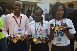
LAKE BASIN INNOVATION AND INVESTMENT WEEK(LBIIW)
Kid’s Hackathon
This conference was guided by the theme, “Promoting innovation for sustainable development”. One of the core activities that I got to volunteer on was the Kids hackathon session, whereby kids from the lake region were being empowered on how to make toys and the use of robotics and also on how they can use their talents to bring solutions.
What is the requirement to be a surveyor in Kenya?
Under the Constitution of Kenya for someone to be able to practice surveying fully as a career, he/she must be licensed and should be a full member of ISK (Institution of Surveyors of Kenya) or he/she should work under a licensed surveyor.
How did you get into surveying?
I love maps because they do speak in a unique way. Maps can convey information in a way that no human eye can see, through interpretation and visualization. My passion for space and environment saw me take Geospatial information science and surveying as a career, because it gives me an opportunity to map out phenomena that have spatial characteristics and also to discern spatial relationships that do exist between features and why these relations happened.
I have grown my career through immense support and guidance from my lecturers and my mentors who are in the same industry, who have constantly empowered and mentored me to be where I am today.
How long have you been in the industry?
I have been in the Geospatial and survey industry for 1 year and half.
What Associations and Organisations are you apart of?
Maseno University
Women in GIS
PASAMU(Planning association of students of Maseno University)
GIS chapter(Maseno University)
Why do you want to be a GKIS Ambassador?
Get Kids into survey is a platform that instils core career values to the younger generation by empowering and mentoring them. I would like to be an Ambassador of this organization so that I can be a change to the younger kids. I would like to encourage and produce Geospatial engineers and surveyors from this generation and also from the disadvantaged groups in the society.
Why is it important for Kids to know Surveying and the wider Geospatial industry?
Geospatial information science and Surveying is a human interactive discipline that puts into consideration the opinions and the need of the community through Participatory GIS (PGIS).
It is important for kids to know Surveying and GIS because it will shape them to be key players, decision makers and critical thinkers in solving problems that are felt in the contemporary world by providing long term solutions by the use of spatial data.
Through this, they will also get to have a greater understanding on planet earth and on the importance of conserving the natural environment by use of maps and spatial data as a platform of making critical decisions pertaining the same.
What are you going to do as an ambassador for Get Kids into Survey (GKIS)?
As a Get Kids into Survey ambassador, I plan to engage all primary school and secondary school children in my community. I would like to be a change by empowering and mentoring them on core career values especially on what Geospatial Information Science and survey entails.
I believe that out of this, many young children will feel empowered by guiding them on the importance of using their God given talents effectively and on how to make wise career choices when the right time comes.
What are your hobbies?
Travelling to new places
Reading a book
Cooking
Environmental conservation
If you could choose a Get Kids into Survey character, what would it be?
The character would be a Bear representing a Geospatial analyst. The character will represent the day to day roles of a geospatial analyst, who uses GPS for spatial data collection and maps for representing features.
What posters and resources would you like to see next from Get Kids into Survey (GKIS)?
GeoSquad
Utilities poster
Forestry posters
Crime scene investigation posters
Anything else you would like to mention?
“The future of our nations and the next generation is our key responsibility. A nation that invests and takes care of its children and their welfare is set to prosper”.
We use cookies on our website to give you the most relevant experience by remembering your preferences and repeat visits. Read More.
This website uses cookies to improve your experience while you navigate through the website. Out of these, the cookies that are categorized as necessary are stored on your browser as they are essential for the working of basic functionalities of the website. We also use third-party cookies that help us analyze and understand how you use this website. These cookies will be stored in your browser only with your consent. You also have the option to opt-out of these cookies. But opting out of some of these cookies may affect your browsing experience.
Necessary cookies are absolutely essential for the website to function properly. This category only includes cookies that ensures basic functionalities and security features of the website. These cookies do not store any personal information.
Any cookies that may not be particularly necessary for the website to function and is used specifically to collect user personal data via analytics, ads, other embedded contents are termed as non-necessary cookies. It is mandatory to procure user consent prior to running these cookies on your website.
Monopoly Sponsor Info Sheet Download
Please fill out the form below to download our Monopoly Sponsor Info Sheet Download:
Autumn Poster Hotsheet Download
Please fill out the form below to access our Poster Hotsheet:
Summer Poster Hotsheet Download
Please fill out the form below to access our Poster Hotsheet:
Spring Poster Hotsheet Download
Please fill out the form below to access our Poster Hotsheet:
Poster Hotsheet Download
Please fill out the form below to access our Poster Hotsheet:
Re-Print Hotsheet Download
Please fill out the form below to access our Re-print Hotsheet:
Winter Poster Hotsheet Download
Please fill out the form below to access our Poster Hotsheet:
Homework Project Info Pack
Please fill out the form below to access our Homework Project Information Pack:

 “Gemma Alcock runs Skybound Rescue which specialises in flying drones to save lives.
 We always knew we wanted to create a comic book for the industry and so in 2019 we set out to find ourselves the perfect writer for the job. We just so happened across Mat, our brilliant writer, teacher and friend.
 We require sponsors of Activity Pages for the Comic Book. We currently have a few spaces remaining, please see if any of these activities take your fancy. Or design your own game:
 If you are not a surveyor, what do you do? President of the
  What are you going to do as an ambassador for GKiS? Continue to support and work with FIG, NSPS, young surveyors and other groups to open the eyes of young people to the amazing world of surveying.


 Let us introduce you to our latest Brand Ambassador; Assumpta Jebichii, a final year student pursuing Geospatial Information Science at Maseno University, Kenya. Assumpta is dedicated, detail oriented and an approachable expert of GIS, remote sensing and survey, who attributes success to outmost discipline and determination. She has excelled in areas such as Geospatial software management (ArcGIS and AutoCAD civil 3D), data collection and research.
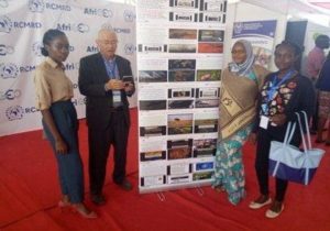
 If you are not a surveyor, what do you do? I am an associate professor of GIS at University of Central Florida in Orlando, Florida. I also am the Founding Director Citizen Science GIS and GeoBus.
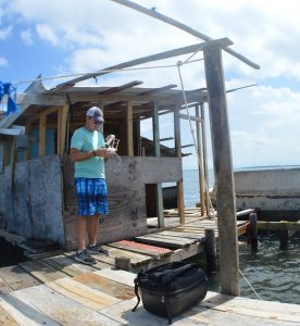 Why do you want to be a GKiS Brand Ambassador? I believe in supporting and inspiring science’s next generation through hands-on educational opportunities. I am inspired by the global reach and positive energy of this GKiS community, and wanted to a part of the great work happening around the globe.
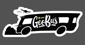 If you/your company had a GKiS character, what would it be? A drone operator for sure. We love flying drones, especially in coastal environments near islands and reefs.