the profession or work of examining and recording the area and features of a piece of land so as to construct a map, plan, or detailed description of it. “a chartered surveyor has acquired a practical knowledge of surveying” ·
Surveying has been around for hundreds of thousands of years. Surveyors and Engineers would have been used to build the Egyptian Pyramids and even to find the Titanic. A surveyor uses maths and geography as part of his or her tool kit.
Perfectly described by RICS “Surveyors keep traffic flowing, water running and people moving. They shape our roads, bridges and tunnels, our skyscrapers, stations and stadiums. They work in mines and in fields, on cliffs and on beaches. They value the houses we live in and the places we work in. They create safer homes and happier communities.
And they’re busy shaping our future too: helping to regenerate deprived areas and planning smart cities connected by the Internet of Things, while pioneering safer, more sustainable and more environmentally friendly building methods.
Surveyors work closely with a wide range of people: architects and engineers, bankers and ecologists, town planners and property developers. And they use the latest technologies: flying drones to map land and measure buildings, creating virtual reality models of buildings, and using Big Data to tackle global issues like climate change, migration and urbanisation.
There are more than 100 varied career roles across the surveying profession in three main sectors: construction and infrastructure; property; and land”.
Did You Know: In the 1860’s an English surveyor, William Matthew Flinders Petrie, surveyed the great pyramid in an evident attempt to show that its measurements were related to the English system of measurement and that the pyramids had been built in feet and inches.
How did surveying start?
There is some evidence of boundary surveying from as early as 1400 BC from along the valleys and plains of the Tigris, Euphrates, and Nile rivers. There is also a representation of land measurement on the wall of a tomb at Thebes which show the measuring of a grainfield with a rope with knots or marks at regular intervals (head and rear chainmen).
In 325 BC the Greeks had to use a long line to record distances along the coast. Useful for when they were making their voyages from the Indus to the Persian Gulf. The Greeks also possibly originated the use of the groma, a device used to establish right angles, however, Roman surveyors made this a standard tool.
Soon after the magnetic compass was brought in by the Arab traders. Followed by the astrolabe (measuring the altitudes and elevation of stars), the first odometer, the plane table, and the development of graphic triangulation and intersection. Read more on the history of surveying here.
If you’re looking for great education and fun content for your child to learn about the geospatial industry – find it here! Get Kids into Survey is owned and run by Elaine Ball Ltd. A team on a mission to #Getkidsintosurvey and to save the industry globally!
Ambassador Spotlight ‘Alice Gadney’
Please say hello to our fantastic Brand Ambassador Alice Gadney AKA Captain Alice!
What do you do? I am a Cartographer and studied as a geologist.
How long have you been in the industry? I have been making maps since 2000!
Are you part of any associations or organisations you would like us to mention? I am a Fellow member of the Royal Geographic Society.
Why do you want to be a GKiS Brand Ambassador? To help show how Survey data is essential in making maps- all part of the process!
Why is it important for kids to know about surveying and the wider geospatial industry? Everything is a process- you start with A and end at Z – I use Survey data daily and I then pass the maps on for people to make decisions.. all these processes involves jobs and skills!
What are you going to do as an ambassador for GKiS? I have been distributing many maps out to children and walking them through the questions and discussions.
What are your hobbies? Walking, Photography, Geology, crafting.
If you/your company had a GKiS character, what would it be? I’m already there -Captain Alice!
What poster or resource would you like to see next from GKiS? Agricultural one – or different industries.. or some history and heritage..
The Tales of Exploring HMS Terror
The story of an Arctic Exploration turned ship wreck(s)
HMS Terror began its career as a ship of war, getting involved in the war of 1812 against the United States. HMS Erebus was built slightly later in 1826 by the Royal Navy.
The two ships ‘left England in 1845 in order to search for the North-West Passage – a vital sea route between the Atlantic and Pacific oceans. The expedition was commanded by Captain Sir John Franklin, a seasoned polar explorer who had already led two previous searches for the North-West Passage’.
The ships had a total of 7,088 pounds of tobacco on board to be chewed or smoked in pipes. As well as 2,700 pounds of candles to provide much needed light over the winter months. Interestingly the ships also set off with multiple farm animals to be eaten in the early stages (I know what you’re thinking… biggg ships!).
However, unknown to him, Franklin’s final journey to the Arctic would end in tragedy.
‘Both ships were lost, and all 129 men on board perished. It is the worst disaster in the history of British polar exploration!’
What was their mission?
The main aim of the mission was a voyage of scientific and geographical exploration through the North-West Passage. An area which had not been explored before.
‘Making magnetic and meteorological observations would have been a key part of the expedition’s scientific remit, but the men had to do so carefully. Placing cold metal instruments up to the eye could cause the skin to be damaged or even removed, and the men had to hold their breath to stop condensation forming on the glass parts.
Pulling sledges could be difficult, too, if the men were exploring beyond the ship’.
Temperatures outside could drop as low as -48°C overnight, -35°C by day. If they sweat; when they stopped the sweat turned to ice in their underwear. There were a list of other serious problems which could occur, starting with the obvious of frostbite if your extremities get too cold; gangrene may set in; hypothermia; to signs of scurvy.
What happened in this disaster?
The two vessels sailed south down Peel Sound after a winter near Beechy Island. They soon became ice-bound in the Victoria Strait in the Arctic territory of Nunavut. In the spring of 1847 a party travelled across the ice to deposit a written record of their progress at Point Victory.
From this record it’s discovered that in April 1848 the ships were still trapped in the ice and drifting south. Captain Crozier (now leading the expedition after Franklin’s death) ordered the abandonment and the 105 surviving men headed south for the Great Fish River.
2 years passed without any communication from Franklin’s crew. 39 expeditions were launched to find HMS Terror and Erebus in the Arctic, it was not until the 1850’s that any evidence began to emerge. These relics are held in the National Maritime Museum.
The exact circumstances of the 129 deaths are a mystery. However, legend has it that sailors on board the HMS Erebus and HMS Terror resorted to cannibalism!
The BBC have even based a show on this disaster. Although fictionalised it holds many similarities. Watch the trailer here.
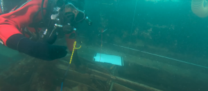
Exploration of the shipwrecks:
Watch now: ‘HMS Terror, the long-lost ship of British polar explorer Sir John Franklin, has been found in pristine condition at the bottom of an Arctic bay, researchers have said. The discovery challenges the accepted history behind one of polar exploration’s deepest mysteries. As researchers and crew from the research vessel Martin Bergmann explain their find, Inuit crew member Sammy Kogvik tells of seeing a mast in Terror Bay years ago. His story was the reason the Bergmann was searching that area’.
Why are we posting this?
This story was used for inspiration for our next educational geospatial poster, named the ‘Arctic Exploration Poster’.
Hopefully this story makes readers realise how different areas of surveying can be applied to many locations, in the present and through history.
By getting involved with our Arctic Exploration Poster you will bring your company to life with its very own mascot, don’t be just a name, be a face, work with our design team and create your very own character! All whilst being the link to boosting the industries lack of surveyors by being seen as supporting its future. So many positives.
Welcome our Brand Ambassador Jamie Stephens from Cornwall, UK!
Where did you study? ONC & HNC in Surveying at St Austell College
What are the requirements to be a surveyor in your area? Being able to walk and breathesimultaneously
How did you get into surveying? Job advert sent to my comprehensive school a few weeks before finishing school and heading off to college.
How long have you been in the industry? Forever, started in June 1987
Are you part of any associations or organisations you would like us to mention? I am a Technical Member of CICES
Why do you want to be a GKiS Brand Ambassador? I feel lucky to have found this career (accidentally) & wish to share my good fortune with the unwitting youth of today.
Why is it important for kids to know about surveying and the wider geospatial industry? Fantastic career with so many different paths to follow and a great mix (generally) of indoors/outdoors work.
What are you going to do as an ambassador for GKiS? Hopefully attend the local primary school (once Covid 19 settles down) to showcase our industry and continue to tag/like/share links to GKIS during my companies’ social media interactions.
What are your hobbies? I coach an u11 football team,
If you/your company had a GKiS character, what would it be? Oggyman (wherever there is a pasty shop he will survey) or something equally cheesy and most definitely Cornish! “Kernow bys vyken” (Cornwall Forever in the Cornish language)
What poster or resource would you like to see next from GKiS? Not sure, ideas are not my forte and you seem to be quite good at coming up with your own!
Anything else you want to add that you think our audience (surveyors, teachers, parents) would be interested in? I am a trustee with a local charity which gives bursaries to local comprehensive school pupils going on to further education
The lesson plan and worksheets spoken about in this blog are available to download here.
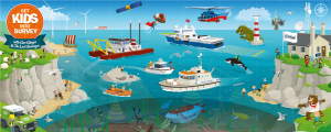
Before the large-scale return of pupils to classrooms around the country, a group of key worker children in a primary school in Manchester spent their final week exploring the world of urban transport. Using the Get Kids into Survey Transport Exploration Poster, the children investigated the many modes of urban transportation, the infrastructure that enables and supports their use, and the importance of geo survey professionals in helping people to get around – no matter what their chosen form of transport!
Introducing the Project
Having taken a good look around the Get Kids into Survey Transport Exploration Poster, the children were set an introductory quiz, all about the world of transportation. The questions focused on superlative aspects of the topic – the longest runway; the widest highway; the highest railway, etc., in order to spark curiosity around modes of transport that might otherwise seem somewhat common place.
The quiz was administered and completed electronically, via the same platform that the children were using to support their home learning. This allowed them to do simultaneous online research and to look further into the results they found when their initial discoveries piqued their interests.
Walking to Learn
Having completed the quiz, the children returned to the exploration poster for a closer look. They identified walking as a popular mode of transport for the people of Middletown, which sparked discussions about how their own walking activity had increased during periods of lockdown – it being one of the few outdoor activities that they could easily keep up. We discussed the advantages of walking as a mode of transport, both personally and in terms of environmental impact, and we thought about the positive difference it could make if people kept up their new-found enthusiasm for walking after lockdown ended.
To this end, we looked at initiatives that encourage walking over other means of transportation – especially those that generate pollution. In particular, the children found out about the ‘Living Streets’ organisation, who campaign for better walking infrastructure (which the children identified as an area for geo survey work) while encouraging people to walk wherever they can. One initiative, the ‘WOW Challenge’, rewards children for walking to school with badges and certificates. The children were tasked with producing persuasive materials that would encourage other pupils to keep up their good walking habits upon their return to school.
Human Sat Nav
To expand upon the idea of walking being a hugely beneficial mode of transport in many different ways, the children were asked to think about the one aspect in which it seemed impossible for walking to come out on top: speed. We explored the idea of using footpaths in order to ‘beat a car’, and pupils were asked to explore their local area to see if they could plot a journey that would be faster on foot than in a car! This really brought to light the importance of well-planned and well maintained pathways, and what is possible in terms of getting from A to B if you have the right path ahead of you! As a group, they managed to find just such a journey – a three minute walk, and a four minute drive!
Transport Top Trumps
Returning to the Transport poster, the children were challenged to compare the various means of personal transportation that they could see in action – focusing particularly on those beyond the realm of motorised vehicles. The children were asked to compare the methods of transport they found under four criteria: speed, safety, comfort and exercise. They presented their findings in the form of Top Trump-style fact cards.
The Ultimate Mode of Transportation
For their final task, the children considered the limitations of the motorised vehicles from the poster. They could see that there were vehicles in the water, on the land, and in the air, but they were all limited to their own geographical zone. But what if this didn’t have to be the case? Might it be possible to design a vehicle that could travel over land, water and air? This was the children’s final task, and their creations did not disappoint!
This project, inspired by the Get Kids into Survey Transport Exploration Poster, provided the children with a much greater appreciation for planners and geospatial experts, whose work makes it easy for them to get around, no matter which mode of transport they choose! It also helped to raise awareness of issues like pollution and congestion, and brought to light some of the ways that young people can start to tackle these problems and act in an environmentally responsible way.
Report compiled by Mathew Sullivan, FRSA Teacher, Author and Educational Consultant
Ambassador Spotlight ‘Carlos Betancourt’
Where did you study? I studied Civil Engineering in El Salvador.
What are the requirements to be a surveyor in your area? Locally, Land Surveyors had been linked mostly to Civil Engineering. There was a degree on land surveying in the early 1900’s but with time it was abolished. Technical schools formed some generations of surveyors with the sole purpose of assisting civil engineers. At some point in history it was considered a repetitive task that anyone could perform.
With the introduction of electronic instruments and GNSS receivers in the early 90s some universities updated their equipment but surveying was never added as a career. Being one of the most technological careers, with a broader scope of applications, and an increasing demand for geospatial information, a new breed of surveyors needs to come along. It’s a challenge not just to bring kids into the career, but to get Universities to add Surveying and other Geospatial careers to their programs.
How did you get into surveying? I got into surveying by accident. I was studying electronic engineering right after high school, in the early 1990s, one day I was listening to a professor ask us to imagine electrons flowing. Suddenly, I thought I wouldn’t see myself doing this for the next 20 years. So the next semester I switched to Civil Engineering and got a job at a construction site just to be sure I was not making a wrong decision. I was working hard drafting and calculating when one day a muddy guy came along and told me, do you want to know where the data came from?
Saying yes to that request is a decision I’ll never regret, I found myself standing behind an old and dusty Wild T-16, looking through its telescope and I found what I would like to be the rest of my life. One thing led to another and in a matter of time ended up working for a local Leica reseller, selling and training customers creating relations with universities. Next I was hired by Carlson Software to do basically the same but on a larger scale in a huge chunk of Latin America and the never ending learning process has not stopped since day one. Now I run a small business, I’m a local reseller, and I’m devoted to discovering new ways of helping surveyors and their customers get the results they want.
How long have you been in the industry? 25 years and counting
Are you part of any associations or organisations you would like us to mention? Rumbo GNSS SA de CV
Why do you want to be a GKiS Brand Ambassador? Surveying is a highly technical and self rewarding occupation, we use all the toys that appear on the movies, GPS receivers, lasers, satellite images, 3D models etc. Kids need to add to their career option of being a Land Surveyor for sure.
Whilst traveling I found that the perception about Surveyors is totally wrong, and many students lack excitement, passion for the industry, and have a “it is what it is” attitude that prevails and we must change that by exposing how fascinating, rewarding and fun the profession is. In a world where isolation and social distance may be around for a while, and jobs may be hard to find, land surveying gives the opportunity to get them self employed and provide their services to a variety of customers and industries. We need kids eager to go out and believe that they can change the world, so they have to know that everything they dream of doing will begin and end with a survey.
Why is it important for kids to know about surveying and the wider geospatial industry? We are heading to a world that will be communicating faster and faster, where assets, utilities, and services will be increasingly monitored remotely, the main question about all of them will be “where are they?” So we need to encourage kids to be the ones who do those tasks and attract them into surveying. This generation is already connected, technology savvy, that if we add the location ingredient to their knowledge we can create the next breed of professionals that will produce that highly demanded geospatial information.
What are you going to do as an ambassador for GKiS? First I would translate the posters you have in English, into Spanish. Plus with your help I could post information in Spanish onto your media channels. Locally I can approach high schools to show kids what they can do with surveying hardware and mapping software and how the information produced is relatable to other careers. I have contacts in universities region wide which is helpful, I may look for government offices that create youth development programs in order to expose surveying as a career path. We could approach agencies that demand surveyors services to incentivise surveying tuition in schools, as well as aid agencies like USAID, plus vocational aid funds etc for scholarships to promote surveyors.
In latin America there’s a high rate of school dropouts, due to poverty and delinquency, and surveying can be a way for them to become independent and productive individuals. I would look for tech companies to help teachers get updated and schools to obtain hardware and software for their tuition. I also have industry contacts that I can ask to do lectures online telling what they do, how they do it and why they love to keep on doing it!
What are your hobbies? I love my Labrador dog, training her entertains me, I used to travel for work but do it also for leisure. I’m a football fan (Go Cowboys!), like aerial photography, going outdoors, and I think I’m a decent cook!
If you/your company had a GKiS character, what would it be? Aztecs, Mayas and Incas did great cities, roads, and aqueducts at impossible places. They were great surveyors for sure, I would pick a Jaguar since all of them have it in common.
What poster or resource would you like to see next from GKiS? Latin America is diverse, so I would love to see a poster representing different ethnicities doing surveying tasks, different landscapes and lot of infrastructure that can be made so we can portray: highway and railway constructions, river dams, bridges, the continent is rich in mineral resources so you can include gold, coal stockpiles, reservoirs underground, ruins hidden underneath the jungle, vast agricultural areas that can be surveyed by drone; my ideas are endless.
Anything else you want to add that you think our audience (surveyors, teachers, parents) would be interested in? The world is a small wonderful marble, and a lot of people today just see it through the eyes of others. Surveying is a chance to go out there, explore it, learn from it, preserve it and improve the conditions of the ones who live on it.
Character Spotlight ‘Three Trees PR’
It’s time to introduce our brand new character 3T by our sponsor Three Trees PR! Let’s learn a bit more about them…
Company Name: Three Trees and a Map PR
Location: We’re based in Hampshire in the South of England (3T finds it a bit warm sometimes so we have to keep him supplied with ice lollies!) but work right across the world with friends as far away as Iceland in the North and Cyprus in the South, plus everywhere in between!
Why did you get involved in Get Kids Into Survey?Maps are awesome, we love them – from phone apps to treasure maps. But, maps are only as awesome as the people who put them together. It’s a great job that takes lots of skill.
No matter how much technology changes, we will always need accurate information about people and places to tackle issues like climate change, poverty and disasters. Supporting the next generation of mapping experts is vital. We want to encourage kids who are passionate about making the world a better place to think about a career as a surveyor or mapping expert. Kids your planet needs you!
What do you do?We tell people how mapping and surveying can help solve world problems. Whether we’re writing news articles or speeches, designing animations or websites. spreading the word about the magic of mapping is at the heart of everything we do.
How long have you been in the survey industry?Oh gosh, now I’m worried I’m going to give away my friend Rhian’s age! Shhh don’t tell anyone but she’s been writing about surveying and mapping since 2000 – that’s more than two decades and lots and lots of new developments have taken place in that time. In fact, I think that’s why she likes her job so much, there’s always something new to write about from a changing landscape to cutting-edge technology like virtual reality and artificial intelligence.
How did you get into the industry?I’m new to Three Trees and a Map. Elly helped Rhian to find me when they were talking about how surveying can help tackle climate change. That’s something very close to my heart because I don’t want to lose my home here in the beautiful Arctic.
Rhian has always been passionate about the world around us and inquisitive about people and places. She became map mad when working at Ordnance Survey, Britain’s national mapping agency – I bet if you ask your teachers, you’ll be able to find some of their maps in your classroom!
Funny fact about you:I always wear a woolly hat – I think it makes me look cool.
Favourite piece of kit and why?Did you know virtual reality (VR) is being used more and more in surveying, particularly to survey areas that aren’t very easy to get to on foot? I love VR. The glass are really cool and it’s great for helping bring geography to life so you can explore a place without having to go there (although visiting new places is also important if you want to be a surveyor!).
We also enjoy playing with map sandboxes. They’re a fantastic hands-on way to explore contours and elevations. The map (or topography as we call it) is projected onto the sand which you can pile up or squash down to explore the changes in the landscape.
Favourite survey technique:GPS survey equipment always make me feel like I’m in a sci fi movie. I can’t believe it connects me to satellites up in space so that people can find out where I am and make sure I’m safe.
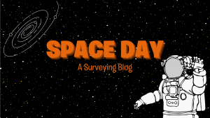
It’s Space Day today!! ‘An unofficial educational holiday created in 1997 by Lockheed Martin, Space Day aims to promote the STEM (science, technology, engineering, and mathematics) fields among young people’.
What better way to celebrate than to explore some of the most fascinating space blogs on the internet… including a surveying aspect anyway. Let’s begin.
Do you fancy learning about surveying the stars?
In this mini course you’ll be able to:
–Understand the concept of triangulating distances to distant objects, including stars.
-Explain why space-based satellites deliver more precise distances than ground-based methods.
-Discuss astronomers’ efforts to study the stars closest to the Sun.
“Here on this very website, we describe surveying as, “the measurement and mapping of our surrounding environment using mathematics, specialised technology and equipment”.
As humanity reaches out to the cosmos, surveying techniques once again are called upon to mark our place in the universe. What is surveying’s role in exploring Mars?”
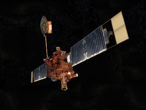
Ever wondered how astronomers map celestial objects in the sky? New and improved ground-based telescopes and spacecraft are going to aid with this a lot. Including the star of this article, the Gaia Spacecraft by the European Space Agency.
Learn more about the mission that will map the positions and distances of roughly one billion stars:
Wandered about taking the next steps to become an Astronomer?
The University of Nottingham have started to offer a 4 year long PhD/MPhil called ‘Engineering Surveying and Space Geodesy’.
“This PhD is based within the Nottingham Geospatial Institute (NGI).
NGI is a leading cross-disciplinary research and teaching institute, specialising in spatial and location-based science and engineering, using the technologies of satellite positioning, remote measurement systems and integrated sensor technologies”
This website uses cookies to improve your experience while you navigate through the website. Out of these, the cookies that are categorized as necessary are stored on your browser as they are essential for the working of basic functionalities of the website. We also use third-party cookies that help us analyze and understand how you use this website. These cookies will be stored in your browser only with your consent. You also have the option to opt-out of these cookies. But opting out of some of these cookies may affect your browsing experience.
Necessary cookies are absolutely essential for the website to function properly. This category only includes cookies that ensures basic functionalities and security features of the website. These cookies do not store any personal information.
Any cookies that may not be particularly necessary for the website to function and is used specifically to collect user personal data via analytics, ads, other embedded contents are termed as non-necessary cookies. It is mandatory to procure user consent prior to running these cookies on your website.
Monopoly Sponsor Info Sheet Download
Please fill out the form below to download our Monopoly Sponsor Info Sheet Download:
Autumn Poster Hotsheet Download
Please fill out the form below to access our Poster Hotsheet:
Summer Poster Hotsheet Download
Please fill out the form below to access our Poster Hotsheet:
Spring Poster Hotsheet Download
Please fill out the form below to access our Poster Hotsheet:
Poster Hotsheet Download
Please fill out the form below to access our Poster Hotsheet:
Re-Print Hotsheet Download
Please fill out the form below to access our Re-print Hotsheet:
Winter Poster Hotsheet Download
Please fill out the form below to access our Poster Hotsheet:
Homework Project Info Pack
Please fill out the form below to access our Homework Project Information Pack:

 What do you do?
 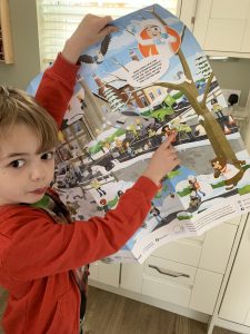 Why is it important for kids to know about surveying and the wider geospatial industry? Everything is a process- you start with A and end at Z – I use Survey data daily and I then pass the maps on for people to make decisions.. all these processes involves jobs and skills!
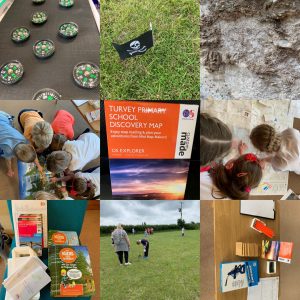
 The two ships ‘left England in 1845 in order to search for the North-West Passage – a vital sea route between the Atlantic and Pacific oceans. The expedition was commanded by Captain Sir John Franklin, a seasoned polar explorer who had already led two previous searches for the North-West Passage’.
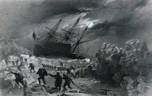 The main aim of the mission was a voyage of scientific and geographical exploration through the North-West Passage. An area which had not been explored before.
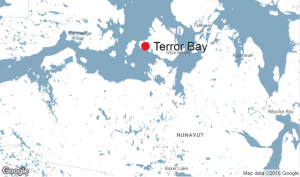 From this record it’s discovered that in April 1848 the ships were still trapped in the ice and drifting south. Captain Crozier (now leading the expedition after Franklin’s death) ordered the abandonment and the 105 surviving men headed south for the Great Fish River.
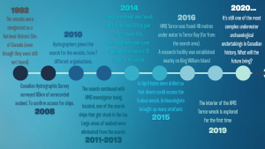
 By getting involved with our Arctic Exploration Poster you will bring your company to life with its very own mascot, don’t be just a name, be a face, work with our design team and create your very own character! All whilst being the link to boosting the industries lack of surveyors by being seen as supporting its future. So many positives.
 Where did you study?
  Why do you want to be a GKiS Brand Ambassador?
  If you/your company had a GKiS character, what would it be?
  Where did you study?
 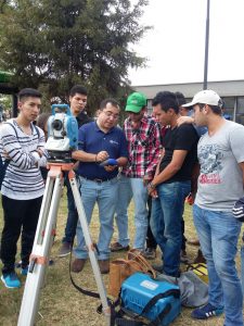 How did you get into surveying?
  Why do you want to be a GKiS Brand Ambassador?
  What are you going to do as an ambassador for GKiS?
  What poster or resource would you like to see next from GKiS?
  Company Name: Three Trees and a Map PR