Welcoming our latest Brand Ambassador Charlie Minshaw from the North East in the UK:
How did you get into surveying? Masters degree in Civil Engineering, daily duties setting out and surveying as a Site Engineer.
What are your plans as a Brand Ambassador? Promote the role/industry in schools/colleges, working alongside my other duties as a STEM Ambassador and my companies Social Value/Community Enhancement work engaging with young people and community stakeholders.
Tell us a bit about what you do? Setting out and surveying in the Railway industry, currently working on construction of 6 new stations. Working for a principle contractor managing different areas of work, production of as-built records and verifying construction works by subcontractors.
Anything else that you’d like to add? My role also promotes sustainability and has a strong emphasis on community relations and stakeholder engagement, so I have a strong network to work with when branching into other topics relating to this sector.
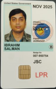
How did you get into surveying? I have been a professional for more than 14 years
What are your plans as a Brand Ambassador? I am excited to become Brand Ambassador and promote it on my social media pages to get kids and youth more awareness about surveying industry and to become surveyor
Anything else you’d like to add? I am excited to become Brand Ambassador and promote it on my social media pages to get kids and youth more awareness about surveying industry and to become surveyor
Ambassador Spotlight ‘Chris Jepson’
Introducing Brand Ambassador Chris Jepson from Washington, USA:
How did you get into surveying? I’m the son of a Surveyor
What are your plans as a Brand Ambassador? To continue developing statewide Outreach efforts.
Tell us a bit about what you do? I work with an effective team of surveyors to make great maps!
Anything else you’d like to mention? Past President of the Land Surveyors’ Association of Washington -2022
How did you get into surveying? When I moved to the UK in 2017 my first neighbours were ocean exploration students. We spent a lot of time hanging out together and it gave me an opportunity to learn about surveying/hydrography. Less than a year into our friendship I decided that I want to work offshore as a surveyor. This completely random friendship provided me with a career I love.
What are your plans as a Brand Ambassador? I am working on creating media content that will help kids to visualise what we are doing offshore. I believe description along with picture/video will make them more curious about offshore surveying. Also I hope they will think it is a cool job to do.
Tell us a bit about what you do? I am an Offshore surveyor working in oil and gas, and renewables industry. My primary duties involve providing subsea position mainly to ROV, conducting geophysical surveys and making sure we are working in the right geodesy.
Character Spotlight ‘CLSA’
Introducing: The “Grizz” by California Land Surveyors Association (CLSA)
The newest member to the Get Kids into Survey family, representing:
Company Name –California Land Surveyors Association (CLSA)
Location –Sacramento, California – The heart of the land survey world, in my opinion!
Why is it important for your company to help Get Kids into Survey? Because the world needs more explorers, innovators, and mapmakers! Surveying combines the spirit of adventure with cutting-edge tech, offering kids a career that’s as rewarding as it is exciting. Plus, who doesn’t want to measure up to greatness?
What do you do? We help surveyors stay sharp, stay informed, and stay connected. From legislative advocacy to education and professional growth, we ensure surveyors across California are always at their best—whether they’re mapping cities or conserving nature.
How long have you been in the survey industry?Let’s just say we’ve been holding the line (and leveling it!) for almost 60 years.
How did you end up getting into the geospatial industry?We were lured in by the perfect combination of technology, the outdoors, and problem-solving. Surveying isn’t just a job—it’s a treasure hunt where every map is a victory!
State a funny fact about you:“They” say I’m extinct, but clearly, they haven’t seen me hitting the trails or double-checking boundary lines. I’m the life of the topo party!
Favorite piece of kit and why?Drones, because who doesn’t love flying high while getting the lay of the land? With a bird’s-eye view and high-tech sensors, drones make surveying smarter, faster, and way cooler.
Favorite Survey technique and why?The SLAM (Simultaneous Localization and Mapping) It’s like magic! Grizz loves how SLAM turns tricky terrain into digital masterpieces in real-time, making him the king of the (data) forest.
How did you choose the character and what does he/she/it represent? Mean to you? What’s his/her name?
Grizz was inspired by California’s iconic Grizzly Bear, a symbol of strength, exploration, and resilience.
What does Grizz mean to you?
Grizz is the ultimate field companion, blending California’s wild spirit with the precision and creativity of surveying. He’s the bear who proves that surveying is bear-y exciting!
What’s his/her name?
Grizz, it’s short, memorable, and packed with character (just like a perfectly mapped plat!).
More about Grizz:
Grizz is the last of the legendary California Grizzlies, and while most think he’s retired, he’s thriving in the surveying world. When he’s not measuring parcels or chasing coordinates, you’ll find him climbing the Sierra Nevada’s, chilling by Lake Tahoe, shredding the gnar, or dropping wisdom at land surveying workshops.
Character Spotlight ‘SAM’
Introducing SAM and their latest character of Bella. All questions are answered by SAM’s Vice President / Mountain Area Director – Tyler Trujillo. Let’s learn some more about them:
Company Name – Surveying And Mapping, LLC (SAM)
Location – Utah Office (Nationwide Firm)
Why is it important for your company to help Get Kids into Survey? Surveying is one of the world’s oldest professions, and its future is brighter than ever! It’s a career that blends science, technology, engineering, and mathematics (STEM) with hands-on, real-world applications, offering kids an exciting mix of adventure and innovation. Today’s surveyors use cutting-edge tools like drones, GPS systems, and 3D mapping technology while working outdoors to explore and shape the environment. With many experienced professionals preparing to retire, there’s a huge opportunity for the next generation to step into this vital field. Introducing kids to surveying early helps them develop critical skills like problem-solving and teamwork while setting them on a path to a stable and rewarding career that has a lasting impact on the world.
What do you do? We are the nation’s largest Managed Geospatial Services™ (MGS™) company, offering Aerial Mapping, Geomatics, Utility Engineering, BIM, GIS, and Engineering Inspection Services across various infrastructure markets.
How long have you been in the survey industry? Personally, been in the industry for 22 years, and working as the Mountain Area Director for SAM who has been in business for over 30 years.
How did you end up getting into the geospatial industry? Had never heard of surveying all throughout school, and had a college program for aviation get canceled during the senior year of high school. A friend of mines Grandfather was a cadastral surveyor for Utah BLM and asked if I would be interested in a summer internship. After spending the summer in the Utah wilderness using GPS and hiking to original corner locations, I found what I wanted to do for my career.
What is your characters favorite subject in School: Definitely Mathematics
Favorite piece of kit and why? A Compass and a Quad Map, it’s the basics of which I learned to navigate in the wilderness during retracement surveys out west. In addition, whenever Bella encounters a compass, she states “that’s what dad does for work”…
Favorite Survey technique and why? GPS data collection – I find it fascinating how accurate, reliable, and repeatable ground positions can be, by collecting data from instruments orbiting earth thousands of miles away.
How did you choose the character and what does he/she/it represent? Mean to you? What’s his/her name? Character’s name is Bella and represents my youngest daughter. I felt it was an opportunity to introduce her to more of the surveying profession as a middle schooler, and she thought it would be cool to be part of the program and have her own GKiS avatar!
Character Spotlight ‘Elevated Land Surveying’
Welcoming Elevated Land Surveying, our latest brand sponsors! They will be appearing in West Coast Get Kids into Survey’s upcoming poster… Let’s learn a bit about them:
Company Name:
Elevated Land Surveying
Location:
Idaho Falls, Idaho, USA
Why is it important for your company to help Get Kids into Survey?
At Elevated Land Surveying, we recognize the importance of inspiring the next generation to explore the land surveying profession. By engaging with young minds, we aim to foster an appreciation for the critical role surveying plays in shaping our communities and infrastructure. Introducing kids to this field can ignite a passion for STEM subjects and ensure the continued growth and innovation of the land surveying industry.
What do you do?
We are a full-service land surveying company offering a comprehensive range of services, including boundary surveys, topographic mapping, construction staking, and ALTA/NSPS Land Title Surveys. Our experienced and licensed surveyor, equipped with cutting-edge technology, ensures precise results for large-scale developments or individual property needs.
How long have you been in the survey industry?
We have been in the land surveying industry for 9 years, delivering reliable and accurate services to clients throughout Idaho, Utah, Nevada, and Colorado.
How did you end up getting into the land surveying industry?
The journey into the land surveying industry began with enrolling in an engineering program, where exposure to surveying techniques and tools sparked a strong interest in the field. During this time, I discovered the unique combination of working outdoors, utilizing advanced technology, and solving real-world problems that surveying offers. What started as a focus on engineering quickly evolved into a passion for land surveying, driven by a fascination with maps, spatial relationships, and contributing to meaningful projects. Elevated Land Surveying was established to turn that passion into a profession that makes a tangible difference in our community.
Favorite piece of kit and why?
Our favorite piece of kit is the robotic total station. It’s a game-changer for modern surveying, allowing for precise measurements while enabling single-person operation. The robotic total station significantly improves efficiency, especially on larger or more complex sites, by automatically tracking the prism and communicating data in real-time. It’s all about the precision, and this tool delivers the accuracy we need to ensure our work is reliable and meets the highest standards. Its versatility and ease of use make it an indispensable part of our workflow, helping us provide top-quality results to our clients
Favorite Survey technique and why?
Our favorite survey technique is boundary surveys. They are the cornerstone of land surveying, providing clarity and certainty about property lines and ownership. Each boundary is like a puzzle, completely unique, requiring us to piece together historical records, legal descriptions, and physical evidence to uncover the full picture. This individuality makes every project a new challenge, keeping the work both exciting and rewarding.
How did you choose the character, and what does he/she/it represent? What’s his/her name?
We selected our character, “Eli the Elk.” The elk symbolizes strength, precision, adaptability, and majesty—qualities we embody in our work. Eli reflects our ability to navigate challenging terrains with care and precision, just as an elk majestically moves through the wild. He represents our commitment to delivering reliable, precise results in every survey.
Character Spotlight ‘Surveyors Exchange’
Introducing Surveyors Exchange Company Inc, who are involved in one of the upcoming West Coast Get Kids into Survey Posters! Let’s learn some more about them:
1. Company Name –Surveyors Exchange Company Inc.
2. Locations–Anchorage Alaska and Fairbanks Alaska
3. Why is it important for your company to help Get Kids into Survey? There is very little mention of surveying in schools and we need more surveyors. There is so many fun tools surveyors can use now such as drones, ground penetrating radar and robotic total stations.
4. What do you do? We are a retail store that sells surveying and construction equipment and supplies. We also offer instrument repairs and training. We also sell and rent satellite phones for when customers have to go out into remote places.
5. How long have you been in the survey industry? Since 1969
6. How did you end up getting into the geospatial industry? Our retail stores have evolved with our customers needs.
7. State a funny fact about you… Musk oxen have four-chambered stomachs, which allow them to process grasses and roughage. They also have a long, shaggy, double-layered coat for insulation. The outer layer is made up of long guard hairs that are shed in late winter, anc he inner layer is made up of shorter, fuzzier wool. This makes it perfect for living in cold, snowy climates.
8. Favorite piece of kit and why? RTK rover with tilt compensation so I don’t have to use a bubble and it’s faster.
9. Favorite Survey technique and why? Drone surveying, Cutting edge technology with lidar mapping.
This website uses cookies to improve your experience while you navigate through the website. Out of these, the cookies that are categorized as necessary are stored on your browser as they are essential for the working of basic functionalities of the website. We also use third-party cookies that help us analyze and understand how you use this website. These cookies will be stored in your browser only with your consent. You also have the option to opt-out of these cookies. But opting out of some of these cookies may affect your browsing experience.
Necessary cookies are absolutely essential for the website to function properly. This category only includes cookies that ensures basic functionalities and security features of the website. These cookies do not store any personal information.
Any cookies that may not be particularly necessary for the website to function and is used specifically to collect user personal data via analytics, ads, other embedded contents are termed as non-necessary cookies. It is mandatory to procure user consent prior to running these cookies on your website.
Monopoly Sponsor Info Sheet Download
Please fill out the form below to download our Monopoly Sponsor Info Sheet Download:
Autumn Poster Hotsheet Download
Please fill out the form below to access our Poster Hotsheet:
Summer Poster Hotsheet Download
Please fill out the form below to access our Poster Hotsheet:
Spring Poster Hotsheet Download
Please fill out the form below to access our Poster Hotsheet:
Poster Hotsheet Download
Please fill out the form below to access our Poster Hotsheet:
Re-Print Hotsheet Download
Please fill out the form below to access our Re-print Hotsheet:
Winter Poster Hotsheet Download
Please fill out the form below to access our Poster Hotsheet:
Homework Project Info Pack
Please fill out the form below to access our Homework Project Information Pack:

 How did you get into surveying? I have been a professional for more than 14 years
 How did you get into surveying? I’m the son of a Surveyor
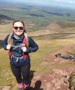 How did you get into surveying? When I moved to the UK in 2017 my first neighbours were ocean exploration students. We spent a lot of time hanging out together and it gave me an opportunity to learn about surveying/hydrography. Less than a year into our friendship I decided that I want to work offshore as a surveyor. This completely random friendship provided me with a career I love.
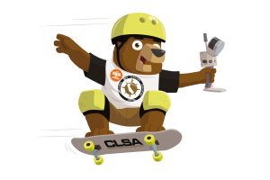 The newest member to the Get Kids into Survey family, representing:
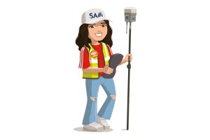 Company Name – Surveying And Mapping, LLC (SAM)
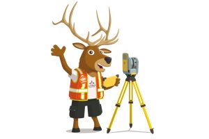 Company Name:
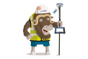
 How did you get into surveying? Masters degree in Civil Engineering, daily duties setting out and surveying as a Site Engineer.