
 COVID-19 brought a whole year of change none of us were expecting. There were some highs and there were lows as I am sure you have all experienced. With that, we are sad to tell you that our lovely Australian Distributor Michelle Brooks of CDM Branding will no longer be representing Get Kids into Survey for the Australasia region. Michelle has gone on to some new pastures and we wish her the best of luck in her new endeavors. And so when one door closes a new one opens. Enter

 We can’t wait to see where these women and the NSW Surveying Taskforce take ‘Get Kids into Survey’ for Australia and beyond.
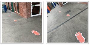
 The group started with the
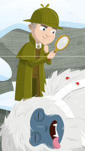
  All signs seemed to point towards this mince pie stealing, toilet roll touting, red-pawed menace. That was, until the class was read the transcript of a phone call to the emergency services that came just moments after the yeti met his end – a call that cast a sudden and murky shadow of doubt on the murderous squirrel theory…
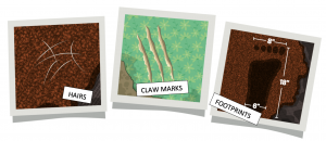
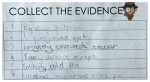 With the shocking revelation that the yeti must have been in the house where the fire was before the blaze got completely out of control, the group was compelled to examine the epicentre of the crime scene once more. They focused on the yellow numbered markers dotted around the yeti, and they learned that these are used in the collection and collation of evidence. They help CSIs and police to keep track of individual pieces of evidence, and in this scene, there were six key items. The group described each one in their notes, and began to think about what they could mean in light of the latest information from the CSI team. The Christmas cracker became a particular item of interest, especially after it was revealed to have contained an expensive gift…

 If you have a character; how did you choose and what does he/ she/ thing represent? Mean to you? – One of the most important projects that we have ever run is the Bridging Kentucky Program… Our bridge surveys are helping sustain safe bridges for school busses, firetrucks, and emergency workers to cross Kentucky Bridges. The
 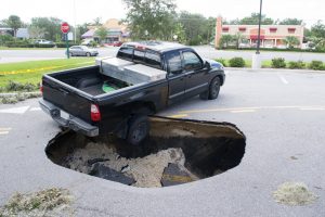 At the start of a series of lessons, the pupils were shown an above-ground image of a large hole in the middle of a street. They were challenged to adopt the persona of a member of the public, and describe what they came across as they approached the scene – paying particular attention to the most hazardous elements…
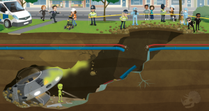 Having set the scene, pupils were given a sneak peek at what lay beyond the entrance to the crater,
 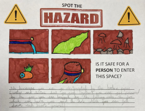 The group managed to identify five separate hazards that might make the crash site a no-go area for the investigators. They noticed that the broken utility pipes posed a problem – especially with the potentially catastrophic combination of electricity and water. They noted that the strange green smoke floating up through the cavity might well be toxic, and that where there is smoke, there is likely fire – just like the one on the alien’s ship! The group also identified the crumbling rocks as a hazard; one that could crush an investigator or cause a cave-in that would trap them underground. Finally, they identified the crater itself as a fairly hefty fall risk! All in all, the group agreed that it would not be safe for a person to enter the space… So how would the investigators ever find out what was down there?
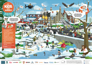
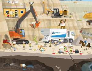 Using the Get Kids into Survey Mining Exploration Poster, pupils explored the technology that surveyors use to investigate and map cavities, caves, rocky areas and hard-to-reach places. They learned about LiDAR technology: devices that emit light rays and measure reflections to create a 3D image of a given space. They also discovered that these scanning devices can be mounted to a variety of vehicles, turning them into mobile mapping systems. The pupils noticed that, in the poster, there were three mobile mapping systems: one where the LiDAR scanner was mounted to a robotic vehicle; one where a scanning device was fixed to a drone, and one where a
 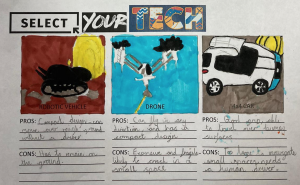 LiDAR unit was mounted to a 4X4 vehicle. The pupils were asked to generate pros and cons for each of these systems in the context of exploring the underground tunnel from the street scene.
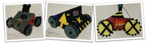
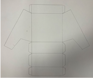
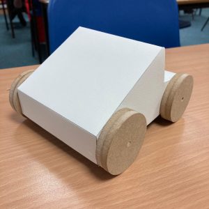
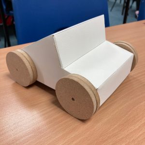
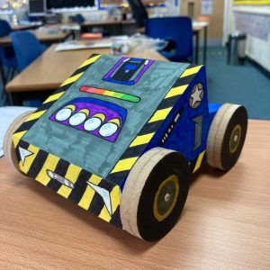
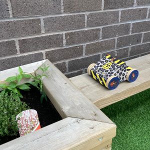 The result of the groups’ creative efforts was a set of prototype vehicles that looked like they could take on any survey situation, no matter how out-of-this-world it was! The children even took their models outdoors to put them through their real-world paces…
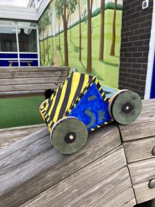 To round-off the project, the group used their drama skills to enact the discovery of the alien ship, and the reactions of the various people in the original scene. The pupils enjoyed the Shared-Space Invaders project immensely, and through the imaginative Get Kids into Survey stimuli, and a creative, cross-curricular teaching approach, they learned a great deal about cutting-edge professional technology, hazard safety, and the fascinating world of underground survey.
 Company Name UPG
Please fill out the form below to access our Translation Options Hotsheet:
In today’s Ambassador Spotlight, we discover a little more about our latest Brand Ambassador Jose Pedraza from Houston, Texas.
 What do you do and what company do you work for?
I am a land surveyor working as Survey Director at Stuart Consulting Group, Inc. We do a lot of work for the local cities, counties, and flood control district, mostly focused on civil engineering.
Are you part of any associations or organisations you would like us to mention?
I am very active in the Texas Society of Professional Surveyors (TSPS) – currently a local chapter director. I am also the east region coordinator for the Texas Young Surveyors (TYS).
Why do you want to be a GKiS Brand Ambassador?
I would like to be a GKiS Brand Ambassador to make a bigger impact on the growth of the geomatics/geospatial industry. I have previously coordinated a booth for the TSPS/TYS at a local student career fair here in Houston as well as participated in the technical advisory committee at a school district developing a geomatics program.
Why is it important for kids to know about surveying and the wider geospatial industry?
I think that exposing students to the opportunities in the geomatics field is important to help encourage growth. There are multiple opportunities for motivated and talented individuals to fill which are currently vacant due to the lack of talent. We have to encourage students into the field since not many educators know about the career opportunities available as geospatial professionals.
What are you going to be doing as an ambassador for GKiS?
I will strive to continue presenting at local careers fairs, schools, and other education avenues available locally. I will also encourage my peers to become more involved in spreading awareness of land surveying. My wife is a teacher, and I can work with her to find more opportunities to share our industry.
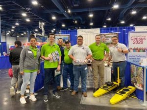
Texas Society of Professional Surveyors at the Houston Hispanic Forum 34th Annual Career & Education Day!
How did you get into surveying?
I got into surveying through luck. I enlisted in the Texas Army National Guard while in my first year of college studying civil engineering. My recruiter asked me what job or specialty I would like. I had no idea there were additional roles on top of just being a soldier, so I asked him to place me in the closest role to a civil engineer that he had. Next thing I knew, I was learning drafting, soils testing, and (most importantly) land surveying as a technical engineer specialist. I didn’t pursue surveying as a full-time career until a few years later after a couple of life-changing surveying missions with the Guard to Chile. (I actually wrote a post about it on LinkedIn a few months ago (see post here)).
What are your hobbies?
I enjoy learning. My hobbies include finding new ways to improve myself and sharing that knowledge with others. I also enjoy working out and binge watching TV shows with my wife.
If you/your company had a GKiS character, what would it be?
Our GKiS character would have to be an investigator (almost Sherlock Holmes but not quite…). Since a big part of our job is searching for the small details, I think that would be fairly accurate.
What poster or resource would you like to see next from GKiS?
It would be interesting to develop some sort of simple learning game that kids can play, highlighting surveying somehow… I remember playing Math Blaster as an elementary school student and that really got me into math. Not sure how much work that would take, but I think that would really get some interested!
Anything else you want to add that you think our audience would be interested in?
I’m just trying to make a positive impact in our community. I think there’s a huge lack of awareness of our industry and know it won’t get better with inaction. I also know there’s a big opportunity to grow our talent pool by looking to diversify our recruiting efforts.