
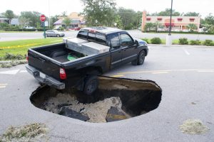
 Having set the scene, pupils were given a sneak peek at what lay beyond the entrance to the crater, via the
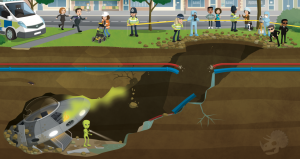
 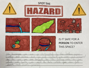 The group managed to identify five separate hazards that might make the crash site a no-go area for the investigators. They noticed that the broken utility pipes posed a problem – especially with the potentially catastrophic combination of electricity and water. They noted that the strange green smoke floating up through the cavity might well be toxic, and that where there is smoke, there is likely fire – just like the one on the alien’s ship! The group also identified the crumbling rocks as a hazard; one that could crush an investigator or cause a cave-in that would trap them underground. Finally, they identified the crater itself as a fairly hefty fall risk! All in all, the group agreed that it would not be safe for a person to enter the space… So how would the investigators ever find out what was down there?
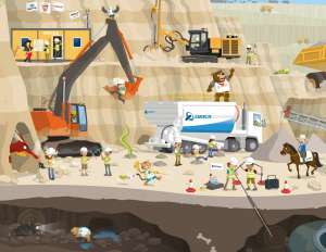 Using the
 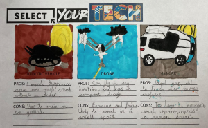 The pupils noticed that, in the poster, there were three mobile mapping systems: one where the LiDAR scanner was mounted to a robotic vehicle; one where a scanning device was fixed to a drone, and one where a LiDAR unit was mounted to a 4X4 vehicle. The pupils were asked to generate pros and cons for each of these systems in the context of exploring the underground tunnel from the street scene.
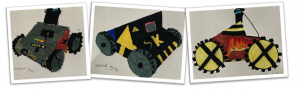
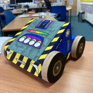
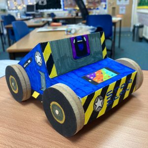
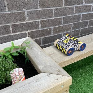 The result of the groups’ creative efforts was a set of prototype vehicles that looked like they could take on any survey situation, no matter how out-of-this-world it was! The children even took their models outdoors to put them through their real-world paces…
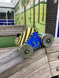 To round-off the project, the group used their drama skills to enact the discovery of the alien ship, and the reactions of the various people in the original scene. The pupils enjoyed the Shared-Space Invaders project immensely, and through the imaginative Get Kids into Survey stimuli, and a creative, cross-curricular teaching approach, they learned a great deal about cutting-edge professional technology, hazard safety, and the fascinating world of underground survey.
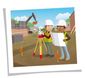 Building Survey
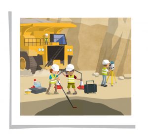 Mining Surveys
 Company Name: UPG

Please fill out the form below to download our Monopoly Sponsor Info Sheet Download:
In today’s Character Spotlight, we discover a little more about one of GKiS’s awesome sponsors “Geoscience Australia”.
![]() Company Name Geoscience Australia is Australia’s public sector organisation responsible for geology and geography. Positioning Australia is one of GeoscienceAustralia priority programs.
Company Name Geoscience Australia is Australia’s public sector organisation responsible for geology and geography. Positioning Australia is one of GeoscienceAustralia priority programs.
Location While our office is located in Canberra we operate infrastructure across all areas of Australia, Antarctica and the Pacific.
Why did you get involved in GKiS? Everything happens somewhere. By promoting the use and understanding of spatial data through GKiS we are hoping that both big and little kids will be able to take advantage of the vast amounts of open access data and services available to develop innovative solutions to important real-world problems.
What do you do? The Positioning Australia program aims to provide an accurate and reliable positioning capability to all Australians. This capability is being delivered through two complementary projects; a national network of continuously operating reference stations that will deliver 3 – 5 cm accurate positioning in areas with access to mobile internet and a satellite based augmentation system that will deliver a 10 cm accurate positioning capability across Australia and New Zealand. Together these capabilities will enable innovation and efficiency across a range of different sectors, including the location and management of utility services (such as those shown in the poster).
How did you get into the Industry? Geoscience Australia has been providing advice on surveying and mapping to the Australian people since 1910, when our predecessor agency the Australia Survey Office was established.
Funny Fact about You? The Positioning Australia program uses a network of GNSS receivers to monitor the movement of the Australian continent. Australia is one of the fastest moving continents travelling between 5 and 7 cm a year to the north-east or as was reported by the BBC the height of a Kangaroo every 20 years.
Favourite piece of kit and why? Low-cost GNSS receivers as these have made it possible for everyone to obtain an accurate position anywhere on the Earth.
Favourite Survey Technique and Why? Precise point positioning. This technique combined with low-cost GNSS receivers will enable high-accuracy positioning for mass market users.
Your Website www.ga.gov.au
![]() What is your character and why did you choose it? Our character is a Tasmanian Devil. This is a uniquely Australian animal found only on the Australian Island of Tasmania. The Devil is currently under threat due to a genetic disease. By providing access to an accurate and reliable positioning capability, researchers will be able to better track the movements of these amazing creatures to understand their behaviours and help keep the remaining populations safe for generations to come.
What is your character and why did you choose it? Our character is a Tasmanian Devil. This is a uniquely Australian animal found only on the Australian Island of Tasmania. The Devil is currently under threat due to a genetic disease. By providing access to an accurate and reliable positioning capability, researchers will be able to better track the movements of these amazing creatures to understand their behaviours and help keep the remaining populations safe for generations to come.