COVID-19 brought a whole year of change none of us were expecting. There were some highs and there were lows as I am sure you have all experienced. With that, we are sad to tell you that our lovely Australian Distributor Michelle Brooks of CDM Branding will no longer be representing Get Kids into Survey for the Australasia region. Michelle has gone on to some new pastures and we wish her the best of luck in her new endeavors. And so when one door closes a new one opens. Enter Narelle Underwood and Michelle Blicavs of the NSW Surveying Taskforce.
These two brilliant women in surveying will represent and distribute resources for ‘Get Kids into Survey’ for Australasia. Narelle Underwood (photo left); Surveyor General of NSW and Chair of the NSW Surveying Taskforce. A NSW representative on the Taskforce National Alliance and a Superstar of STEM. Michelle Blicavs (photo right) is Narelle’s partner in crime when it comes to the NSW Surveying Taskforce. She is also the CEO of The Association of Consulting Surveyors.
We can’t wait to see where these women and the NSW Surveying Taskforce take ‘Get Kids into Survey’ for Australia and beyond.
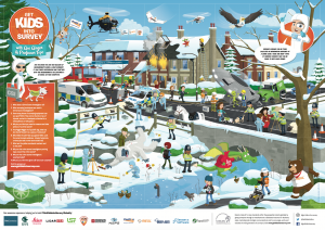
The NSW Surveying Taskforce will be represented in our posters and material by Narelle and her son Lachie flying his drone. See if you can spot them in our upcoming Utilities Australia Poster coming this September.
If you want to join the Australian family of sponsors and ambassadors why not reach out today?
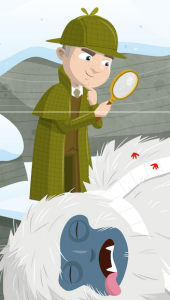
A Cold Case…the Mysterious Murder of the Abominable Snowman. Bringing Geography and Geo Survey to Life –
In the final week of what has been an out-of-the-ordinary academic year, a group of key worker children set out to solve a fittingly out-of-the-ordinary mystery: the baffling demise of the abominable snowman. They were asked to take on the role of CSI – Crime Scene Investigators – to collect, collate and analyse a range of evidence, biological samples and eyewitness accounts, linking them together in order to discover the true culprit behind the tragic departure of the giant yeti…
They spotted the red footprints and the telling toilet roll – following both across the village green, over the bridge, up the tree to find…
All signs seemed to point towards this mince pie stealing, toilet roll touting, red-pawed menace. That was, until the class was read the transcript of a phone call to the emergency services that came just moments after the yeti met his end – a call that cast a sudden and murky shadow of doubt on the murderous squirrel theory…
Reviewing the Case
The frantic call included tales of some odd goings on occurring ‘down by the lake’. The caller reported that a huddle of suspicious characters seemed to planning something, even though, by her own admission, the members of the gang couldn’t actually talk. Luckily, she was able to provide some general visual descriptions, which the group used to search the scene for possible culprits. It wasn’t long before they found some unusual suspects…
A HOT TIP
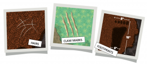
Having identified the group of shifty-looking animals as ones-to-watch, the group received photographic evidence collected from the burnt-out house, not far from where the yeti was found. This brought to light some interesting new information, and made clear the importance of a CSI’s work, their methods, and how they help in solving crimes. The group linked their previous learning on LiDAR and measuring technology to the work of CSIs, noting that a lot of the survey techniques with which they were already familiar were being used at the crime scene. For example, there was a GPR scanner being used to ‘look’ for anything suspicious below ground, and there were LiDAR scanners collecting digital image data to facilitate the creation of a virtual crime scene. There was also some good old fashioned photography going on, and the pictures taken inside the house where the fire had occurred were of particular interest to the pupils…
Whilst the hairs might have been put down to the family dog – and the claw marks too (although they looked too wide and too deep to belong to Bingo the friendly beagle), the size of those footprints pointed towards one very distinct owner. However, it wasn’t enough for the pupils to assume that they belonged to the yeti; putting him at the scene of the house fire was a big step to take – pun intended! They had to know for sure that these footprints belonged to something abominable. It was time for a crime scene recreation!
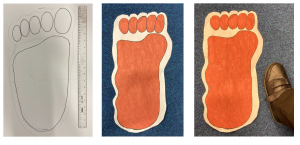
First, the pupils took the dimensions from the footprint and created their own replicas:
Then, using the stride measurements taken by the CSI team (80 inches between each print), the group recreated the path taken by the owner of the footprints through the house:
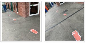
Once the footprints had been laid at carefully measured intervals, the group took turns to try and cover one of the single steps with their own feet. Whilst some pupils almost ended up doing the splits, and a few members of staff also tried their best, no-one was able to match the stride length of the owner of the footprints. A second challenge saw the pupils taking leaping bounds along the footprint path to see how many of their steps it would take to cover the same distance that the footprint owner covered in eight. Even with their best, bounciest efforts, the lowest any pupil managed was thirteen steps. These endeavours confirmed the group’s suspicions: there was only one character in the scene tall enough to leave footprints like that… the yeti himself. And if those footprints were followed, the pupils noted that they led back to the burning house – putting the yeti at the scene of a possible arson attack!
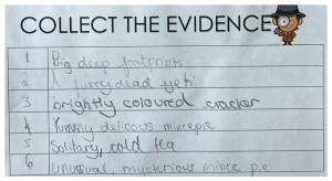
Collect the Evidence
With the shocking revelation that the yeti must have been in the house where the fire was before the blaze got completely out of control, the group was compelled to examine the epicentre of the crime scene once more. They focused on the yellow numbered markers dotted around the yeti, and they learned that these are used in the collection and collation of evidence. They help CSIs and police to keep track of individual pieces of evidence, and in this scene, there were six key items. The group described each one in their notes, and began to think about what they could mean in light of the latest information from the CSI team. The Christmas cracker became a particular item of interest, especially after it was revealed to have contained an expensive gift…
Social Media Shocker
While re-examining the crime scene, the group noticed the two shady agents across the road, both of whom were looking very concerned. It seemed that they had been making their own inquiries, and had turned up some very interesting evidence from their analysis of the villagers’ social media pages…
The pupils recognised those shadowy silhouettes immediately: the animals from their suspect sheet! It was beginning to look like this village had its own squad of furry vigilantes, who tracked down criminals and brought them to justice. But if the ducks, the sheep, and that sneaky squirrel were the good guys, what did that make the yeti?
It was time for a final review of the evidence…
Large footprints, claw marks and hair put the yeti at the scene of the house fire before the blaze. One Christmas cracker containing a precious gift was reported missing from the house.
CSI found toilet paper at the scene, matching the brand used by the mysterious vigilante whocaught the bank robbers.
A series of extremely large footprints were found crossing the river bank, heading away fromthe house where the fire was and leading to where the yeti was found. This suggests that theyeti was running from the house when he met his demise.
A group of unsuspecting animals seem to have become a team of crime-fighting vigilantes,using baked goods as bait, and toilet roll as a weapon.Finally, the pupils were asked to prepare their conclusions:The yeti was trying to steal the Christmas cracker from the house. He was the criminal because he also started a fire. The animal suspects were actually the heroes of the day, luring him and capturing him. They set a trap with mince pie and toilet paper (the toilet paper was their weapon). I was really shocked but it makes perfect sense. The reason why the yeti ran and cut through the fence was because he could smell the mince pie, but he was also trying to escape the house before he was burnt like he’d been put in the oven. I can tell it was the yeti, because nothing else could have left footprints that big! The animal suspects were acting very sneaky so they could plan the things they needed to do to stop the yeti once and for all. I think that the yeti was an arsonist because he was in the house before the fire happened, so he must have caused it. This criminal has thankfully been stopped. The social media pages make the animal suspects the heroes.– Year 4 Pupil, aged 9The group thoroughly enjoyed the Get Kids into Survey CSI learning project; they were excited by its mix of intrigue and workable clues – they felt very smart to have cracked the case by the end! The project also enhanced both their knowledge and perception of survey techniques. The fact that these methods and technologies have applications beyond mapping, architecture and physical geography made the world of geo survey even more interesting!
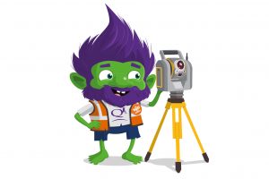
In today’s Character Spotlight, we discover a little more about one of GKiS’s newest sponsors “QK4” while interviewing Ben Shinabery, Land Survey Director of QK4
Ben Shinabery, Land Surveyor Director at Qk4
Company Name – Qk4, Inc.
Location – Kentucky, Indiana, Tennessee, & Georgia, USA
Why did you get involved in Get Kids into Survey? I grew up as the son of a surveyor and want to introduce other kids to all that surveying offers
What do you do? – I tell people that I am a “High Definition Digital Terrain Modeler” that creates virtual reality environments for engineers… a Land Surveyor…
How long have you been in the Survey Industry? – If I count walking with my dad through corn fields looking for section corners when I was a kid, over 30 years. I have already started teaching my son and daughter how to be a surveyor…
How did you get into the Industry? – Having a land survey father helps, but I also liked math and science in school. I also love being outdoors and enjoying different location surveys: mountains, farms, creeks, cities, and caves
Funny Fact about you – I collect and throw axes… I also love spending time looking at old maps of places that I have been or would like to visit some day
Favourite piece of kit and why? – I carry my drone with me wherever I go, just in case we need to map a jobsite
Favourite Survey technique and why? – 3D Laser Scanning is my favorite way to collect the highest resolution digital model of existing survey features whether above ground or underground… look up “Big Bat Cave LiDAR” for an underground cave scanning tour in Kentucky
If you have a character; how did you choose and what does he/ she/ thing represent? Mean to you? – One of the most important projects that we have ever run is the Bridging Kentucky Program… Our bridge surveys are helping sustain safe bridges for school busses, firetrucks, and emergency workers to cross Kentucky Bridges. The Qk4 Bridge Troll inspects and maintains bridges, and because he cares for the safety of all, he doesn’t charge any crossing toll.
Character Spotlight “Position Partners”
In today’s Character Spotlight, we discover a little more about one of GKiS’s awesome sponsors “Position Partners”.
Company Name – Position Partners
Location – Australia, New Zealand, Asia
Why did you get involved in Get Kids into Survey? – We thought it was a great idea, well executed by Elaine and team! Kids don’t learn what surveyors do but they work with really cool technology so it was a great idea to promote the profession
What do you do? – Marketing Manager for Position Partners – we supply and support intelligent positioning solutions for the geospatial, construction and mining industries
How long have you been in the Survey Industry? – Our founding companies were brought to life more than 30 years ago. I’ve worked with geo technology suppliers for 13 years
How did you get into the Industry? Though the good fortune of meeting and working with Martin Nix
Funny Fact about you – I have a unique ability to memorise numbers but am hopeless at maths (I could never cut it as a surveyor!)
Favourite piece of kit and why? RPAS because who wouldn’t want to fly a remote control plane at work?
Favourite Survey technique and why? I don’t think I can comment on that, see fun fact above
If you have a character; how did you choose and what does he/ she/ thing represent? Mean to you? Plumb Bob the Koala because they are unique and worth protecting, like the survey profession!
Get Kids into Survey Character Spotlight “SheMaps”
In today’s Character Spotlight, we discover a little more about one of GKiS’s awesome sponsors “SheMaps”
Company Name: She Maps
Location: Australia
Why did you get involved in Get Kids into Survey? Dr Karen Joyce, one of our co-founders, is passionate about the spatial industry, and getting more kids to understand the potential of the industry and the technology involved, beyond what they think it is, is important. Get Kids into Survey is also just a really fun brand to be working with.
What do you do? You are all about increasing the diversity in the STEM workforce. We do this by working with schools to run drone programs. This is STEM by stealth, as we weave into our programs a whole lot of information about the spatial industry, as well as providing real world applications, but the students often think they are just having fun flying drones!
How long have you been in the Survey Industry? Karen has been in the spatial industry as a remote sensing scientist for over 20 years.
How did you get into the Industry? When Karen was at Uni she chose her subjects by what would get her into the outdoors the most, and onto the Great Barrier Reef. With a love for the sciences and environmental monitoring in there as well, she was drawn towards remote sensing!
Funny Fact about you – Karen and Paul (our other co-founder) met when they were both serving in the Army. After Karen moved to Wellington in New Zealand, and being too cold for 2 years, they moved to Darwin, Australia in the tropics – from the freezer to the frypan!
Favourite piece of kit and why? Definitely drones! They are just so versatile and have enabled Karen to get highly detailed spatial data of her research sites.
Favourite Survey technique and why? Karen loves being able to set up a drone mapping mission on Heron Island on the Great Barrier Reef, and having her drone fly an autonomous mission, collecting data. It is just so satisfying to be able to work with this technology, to do something I only dreamed of being able to do when I started at Uni.
If you have a character; how did you choose and what does he/ she/ thing represent? Mean to you? We have Dronie – She is currently having a children’s book written about her adventures around Australia. Dronie represents all the women who have challenged themselves to overcome adversity and industry stereotypes and succeed in the STEM workforce.
Extra Terrestrial Investigations. Shared Space Invaders. Bringing Geography Geo Survey to Life
During lockdown, a group of key worker pupils from a Manchester primary school embarked on an out-of- this-world learning adventure! They were presented with an intriguing scene: a large crater in the middle of a high street, caused by a strange object that had fallen from the sky, which lay buried at the end of a long, dark and foreboding tunnel. Since this was no place for human exploration, the group put their geo survey skills to the test to find a way to explore the tunnel safely, and discover the extra-terrestrial cause of the colossal crater…
Introducing the Project
At the start of a series of lessons, the pupils were shown an above-ground image of a large hole in the middle of a street. They were challenged to adopt the persona of a member of the public, and describe what they came across as they approached the scene – paying particular attention to the most hazardous elements…
“…As I was walking down the pavement, I saw a group of people gathered together. They were being very noisy, shouting things like, “It fell from the sky!”, and, “What could be down that deep, mysterious hole!?” When I got closer, I realised what all the commotion was about. There was a huge crater right in the middle of the pavement! I could see broken utility lines spitting water and sparks of electricity. Even stranger, there was green smoke coming from the dark, gloomy hole. It smelled like rotten bananas! I wanted to get closer, but the police started pushing everyone back – I almost tripped over with the herd of people coming towards me. Suddenly, I saw these weird-looking scientists in strange suits going towards the scary crater, so that they could investigate this curious matter…”
They explored the scene in detail, focusing on the various hazards – which were much more visible in the expanded image – in order to assess the viability of sending an investigation team into the tunnel.
The group managed to identify five separate hazards that might make the crash site a no-go area for the investigators. They noticed that the broken utility pipes posed a problem – especially with the potentially catastrophic combination of electricity and water. They noted that the strange green smoke floating up through the cavity might well be toxic, and that where there is smoke, there is likely fire – just like the one on the alien’s ship! The group also identified the crumbling rocks as a hazard; one that could crush an investigator or cause a cave-in that would trap them underground. Finally, they identified the crater itself as a fairly hefty fall risk! All in all, the group agreed that it would not be safe for a person to enter the space… So how would the investigators ever find out what was down there?
Geo-tech to the Rescue
Using the Get Kids into Survey Mining Exploration Poster, pupils explored the technology that surveyors use to investigate and map cavities, caves, rocky areas and hard-to-reach places. They learned about LiDAR technology: devices that emit light rays and measure reflections to create a 3D image of a given space. They also discovered that these scanning devices can be mounted to a variety of vehicles, turning them into mobile mapping systems. The pupils noticed that, in the poster, there were three mobile mapping systems: one where the LiDAR scanner was mounted to a robotic vehicle; one where a scanning device was fixed to a drone, and one where a LiDAR unit was mounted to a 4X4 vehicle. The pupils were asked to generate pros and cons for each of these systems in the context of exploring the underground tunnel from the street scene.
After weighing up their options, the group decided that a robotic vehicle-based mobile mapping system would be best suited to their exploration needs; it being small, able to traverse rough terrain, and operated safely via remote control. Now it was time to get to work on their very own prototype!
Lean, Mean, Mine-Exploring Machines
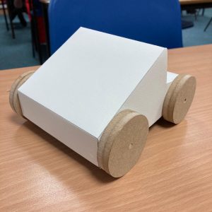
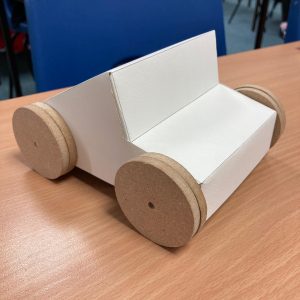
Having analysed the conditions under which their robotic vehicles would have to perform, pupils got to work on designing model prototypes for their own remote controlled, all-terrain modes of exploratory transport.
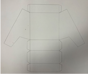
Pupils transferred these designs from 2D sketch work to a 3D net, creating a custom body to fit over a cardboard chassis. They added axels and large wheels for all-terrain performance.
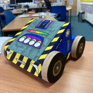
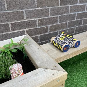
The result of the groups’ creative efforts was a set of prototype vehicles that looked like they could take on any survey situation, no matter how out-of-this-world it was! The children even took their models outdoors to put them through their real-world paces…
To round-off the project, the group used their drama skills to enact the discovery of the alien ship, and the reactions of the various people in the original scene. The pupils enjoyed the Shared-Space Invaders project immensely, and through the imaginative Get Kids into Survey stimuli, and a creative, cross-curricular teaching approach, they learned a great deal about cutting-edge professional technology, hazard safety, and the fascinating world of underground survey.
Report compiled by Mathew Sullivan, FRSA Teacher, Author and Educational Consultant
Character Spotlight “UPG”
Company Name UPG
Location Australia
Why did you get involved in Get Kids into Survey? Survey is a profession resulting in being educated in STEM subjects. It’s not well known and is a mix of those disciplines enacted in the real world.
What do you do? Enable surveyors / geospatial professionals with the most practical and efficient technology solutions.
How long have you been in the Survey Industry? UPG is part of The Herga Group and was founded in 1888 in Brisbane. Between 1939 – 1945 Herga repaired instruments for the US forces at night. In 1927 the group was appointed as the Australian Dealership for geodimeter.
How did you get into the Industry? Surveying is one of the oldest professions and they need technology to perform their work
Funny Fact about the you: UPG the dynasty – Run now by a fourth generation Bright
Favourite piece of kit and why? Trimble TSC7. It’s the conductor of an orchestra of hardware solutions.
Favourite Survey technique and why? Integrated surveying. Ties in many hardware technologies with the TSC7.
Whats your character and why did you choose it/him/her/them?
SX10 name = ROBO
TSC7 name = FLASH
The TSC7 solves the problems with its SX10sidekick. TSC7 is the conductor of an orchestra or in this case – of the SX10. The TSC7 is the newest play on a field controller taking it to next level of speed and capability. The SX10 is next level productivity and combined with theTSC7 are an exciting duo of technology.
Cutting edge and best practice
Get Kids into Survey presents “Riegl”
In today’s Character Spotlight, we discover a little more about one of GKiS’s awesome sponsors “Riegl”.
Company Name: RIEGL
Location: We are global! RIEGL has its main bear camp (Headquarters) in Austria, and also has offices around the globe. But more importantly, our clients, (who usually become friends) are using our RIEGLscanners on every continent, and in almost every country in the whole world. Now we just need to put one on the moon!
Why did you get involved in Get Kids into Survey? We love kids. And kids love technology! We want to do our part to encourage the next generation of surveyors, scientists, animators, etc. RIEGL has been a GKIS supporter from day 1! We love the fun comic book style of the GKIS program and want to help get it into the hands of kids who might have never even heard of LiDAR. It’s a springboard to bring in the new talent.
What do you do? We invent equipment that helps engineers, scientists, animators and contractors put their dreams into 3D. Over 40 years ago we started working with LiDAR, which is really just a spectrum of light waves that humans (and bears) can’t see. We think we’ve nearly perfected the equipment that men and women use to create what techies are calling a “Digital Twin”. A Digital Twin is an exact copy of something but it’s virtual…on a computer, TV or movie screen.
How long have you been in the survey industry?Since before you were a twinkle in your father’s eye! 42 years ago a small group led by our founder and CEO Dr. Riegl started the company. I was a rod-bear, and that means I would hold equipment for the rest of the crew. I would also prepare lunches for the RIEGL engineers and technicians – honey sandwiches, my favorite. Now we supply equipment to people all over the world and I get to go to all kinds of amazing places – jungles, deserts, glaciers, mountains, even over the ocean!
How did you get into the Industry? One summer I was playing catching fish in a mountain stream in southern Austria, when a drone flew up in the air nearby. Of course that captured my interest! I’d never seen one like this before. It seemed to be carrying a package, and it was going back and forth in a pattern.
This was very unusual. You don’t often see a drone in the middle of a forest!
So I followed the flight path with my eyes, and watched to see where it would land. I just had to go over and investigate. What the Bear was going on!?!
After a short hike I rounded a clearing and saw what turned out later to be a team of RIEGL engineers.. Everyone seemed really happy, and obviously they were celebrating a successful mission. They saw me and invited me over to see what they were doing.
It turns out they were testing a very small LiDAR scanner that had been mounted on a UAV (drone). The scanner was the “package” that I had seen on the drone. Mystery solved!
The RIEGL team explained me that the team had been doing several experiments that day to test a new scanning system they had invented just for drones. They excitedly added that it had wildly exceeded their expectations!
I was so interested. I had never even heard about LiDAR before that day. Only an hour ago this little unit had been scanning the mountain area and could even scan the riverbed — the ground surface under the water! On a laptop they showed me a 3D image of the mountain and the riverbed. They showed how they could use the data to measure distances and volumes in seconds. Wow! Scientists and engineers would really love this feature.
I had so much fun that day that I asked if they could use a bear like me on staff. Dr. Riegl said, “Sure! You seem like a very smart bear. Let’s give it a try.” Long story short, I started my career at RIEGL that day. I began by helping them pack and load up the equipment, and pretty soon I had a promotion and a full time job.
These days I fly around the world to meet with RIEGL clients, most of whom are scientists, engineers or university professors. My job is to help them understand all the features of the scanners RIEGL, and assist them as they decide which equipment they need for their missions.
That day in the woods changed my life, and I haven’t looked back since.
Funny Fact about you? They designed Gummy Bears after me. (I love them. Especially the orange ones! Swedish Fish too.) Also, I’m ticklish.
Favourite piece of kit and why? I like LOCATE THE TECH! I think it’s like a treasure hunt.
Favourite Survey Technique and Why? I like using the terrestrial laser scanners the best. They may not be the fanciest, but they can do so much! They are like workhorses and you can take them anywhere easily. The scanner and camera fit in one small hard suitcase that has wheels. You can just grab the suitcase and a tripod, and off you go to your next adventure.
With this equipment you can go to some really remote places with minimal fuss and pre-planning, and get amazing 3D pointclouds (Digital Twins!) in a flash. Pack along your favorite sandwich, because often there are no restaurants where we are going!
This website uses cookies to improve your experience while you navigate through the website. Out of these, the cookies that are categorized as necessary are stored on your browser as they are essential for the working of basic functionalities of the website. We also use third-party cookies that help us analyze and understand how you use this website. These cookies will be stored in your browser only with your consent. You also have the option to opt-out of these cookies. But opting out of some of these cookies may affect your browsing experience.
Necessary cookies are absolutely essential for the website to function properly. This category only includes cookies that ensures basic functionalities and security features of the website. These cookies do not store any personal information.
Any cookies that may not be particularly necessary for the website to function and is used specifically to collect user personal data via analytics, ads, other embedded contents are termed as non-necessary cookies. It is mandatory to procure user consent prior to running these cookies on your website.
Monopoly Sponsor Info Sheet Download
Please fill out the form below to download our Monopoly Sponsor Info Sheet Download:
Autumn Poster Hotsheet Download
Please fill out the form below to access our Poster Hotsheet:
Summer Poster Hotsheet Download
Please fill out the form below to access our Poster Hotsheet:
Spring Poster Hotsheet Download
Please fill out the form below to access our Poster Hotsheet:
Poster Hotsheet Download
Please fill out the form below to access our Poster Hotsheet:
Re-Print Hotsheet Download
Please fill out the form below to access our Re-print Hotsheet:
Winter Poster Hotsheet Download
Please fill out the form below to access our Poster Hotsheet:
Homework Project Info Pack
Please fill out the form below to access our Homework Project Information Pack:

 The group started with the
  All signs seemed to point towards this mince pie stealing, toilet roll touting, red-pawed menace. That was, until the class was read the transcript of a phone call to the emergency services that came just moments after the yeti met his end – a call that cast a sudden and murky shadow of doubt on the murderous squirrel theory…
 With the shocking revelation that the yeti must have been in the house where the fire was before the blaze got completely out of control, the group was compelled to examine the epicentre of the crime scene once more. They focused on the yellow numbered markers dotted around the yeti, and they learned that these are used in the collection and collation of evidence. They help CSIs and police to keep track of individual pieces of evidence, and in this scene, there were six key items. The group described each one in their notes, and began to think about what they could mean in light of the latest information from the CSI team. The Christmas cracker became a particular item of interest, especially after it was revealed to have contained an expensive gift…
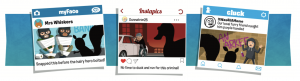

 If you have a character; how did you choose and what does he/ she/ thing represent? Mean to you? – One of the most important projects that we have ever run is the Bridging Kentucky Program… Our bridge surveys are helping sustain safe bridges for school busses, firetrucks, and emergency workers to cross Kentucky Bridges. The
 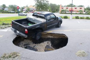 At the start of a series of lessons, the pupils were shown an above-ground image of a large hole in the middle of a street. They were challenged to adopt the persona of a member of the public, and describe what they came across as they approached the scene – paying particular attention to the most hazardous elements…
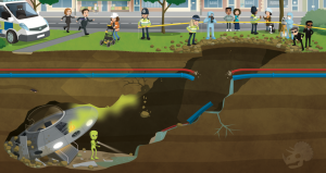 Having set the scene, pupils were given a sneak peek at what lay beyond the entrance to the crater,
 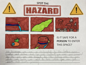 The group managed to identify five separate hazards that might make the crash site a no-go area for the investigators. They noticed that the broken utility pipes posed a problem – especially with the potentially catastrophic combination of electricity and water. They noted that the strange green smoke floating up through the cavity might well be toxic, and that where there is smoke, there is likely fire – just like the one on the alien’s ship! The group also identified the crumbling rocks as a hazard; one that could crush an investigator or cause a cave-in that would trap them underground. Finally, they identified the crater itself as a fairly hefty fall risk! All in all, the group agreed that it would not be safe for a person to enter the space… So how would the investigators ever find out what was down there?
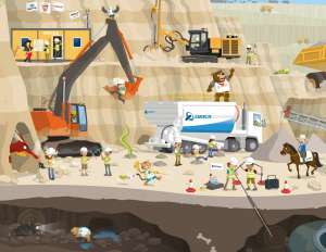 Using the Get Kids into Survey Mining Exploration Poster, pupils explored the technology that surveyors use to investigate and map cavities, caves, rocky areas and hard-to-reach places. They learned about LiDAR technology: devices that emit light rays and measure reflections to create a 3D image of a given space. They also discovered that these scanning devices can be mounted to a variety of vehicles, turning them into mobile mapping systems. The pupils noticed that, in the poster, there were three mobile mapping systems: one where the LiDAR scanner was mounted to a robotic vehicle; one where a scanning device was fixed to a drone, and one where a
 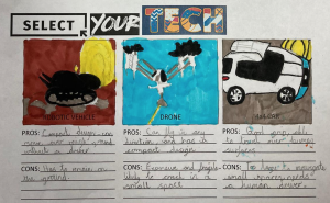 LiDAR unit was mounted to a 4X4 vehicle. The pupils were asked to generate pros and cons for each of these systems in the context of exploring the underground tunnel from the street scene.
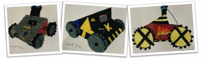
 The result of the groups’ creative efforts was a set of prototype vehicles that looked like they could take on any survey situation, no matter how out-of-this-world it was! The children even took their models outdoors to put them through their real-world paces…
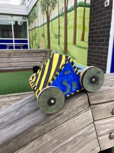 To round-off the project, the group used their drama skills to enact the discovery of the alien ship, and the reactions of the various people in the original scene. The pupils enjoyed the Shared-Space Invaders project immensely, and through the imaginative Get Kids into Survey stimuli, and a creative, cross-curricular teaching approach, they learned a great deal about cutting-edge professional technology, hazard safety, and the fascinating world of underground survey.
 Company Name UPG
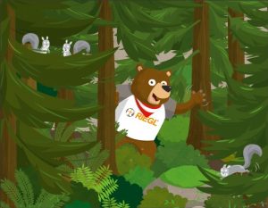 How did you get into the Industry? One summer I was playing catching fish in a mountain stream in southern Austria, when a drone flew up in the air nearby. Of course that captured my interest! I’d never seen one like this before. It seemed to be carrying a package, and it was going back and forth in a pattern.
 COVID-19 brought a whole year of change none of us were expecting. There were some highs and there were lows as I am sure you have all experienced. With that, we are sad to tell you that our lovely Australian Distributor Michelle Brooks of CDM Branding will no longer be representing Get Kids into Survey for the Australasia region. Michelle has gone on to some new pastures and we wish her the best of luck in her new endeavors. And so when one door closes a new one opens. Enter Narelle Underwood and Michelle Blicavs of the NSW Surveying Taskforce.

 We can’t wait to see where these women and the NSW Surveying Taskforce take ‘Get Kids into Survey’ for Australia and beyond.