
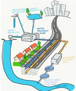
 Community Water Management for a Liveable London (
 What do you do in the Geospatial Industry?
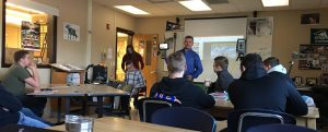
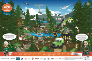
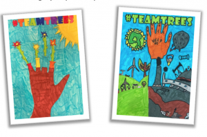
 Pupils used the forestry-themed exploration poster to find out about all the hard work that goes into maintaining, managing, protecting,
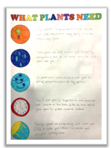 The group added a ‘What Plants Need’ guide to their growing resource bank, detailing five key factors that affect the healthy growth of plants, and the potential consequences that might occur if any of these needs are not met.

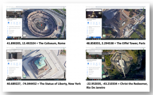 Once the pupils understood the format and function of decimal degree coordinates, they were set a challenge – a virtual treasure hunt – with the goal of locating famed landmarks across the globe.
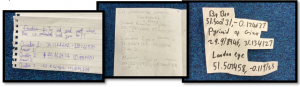 As a final challenge, the pupils were asked to locate the position of their own homes using the decimal degree system. Once they had completed this task, they were asked to pick a specific location in their garden – one that they knew, according to all the work they had done around what plants needed to grow well, would be a suitable place to add a little more green to the world…
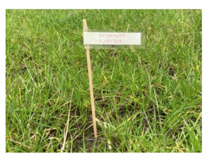 With their perfect plot picked out, the pupils noted down the decimal degree coordinates on a piece of paper and created a marker for their planting spot, which would allow them to keep track of the exact position of their plant. This would hopefully mark the first of many planting efforts, all of which would be logged with precise positioning data that could be used to track growth rates and the effect of factors like weather and care regimes.

 What do you do and what company do you work for?
Please fill out the form below to download our Monopoly Sponsor Info Sheet Download:

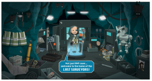
AFTER AN ACTION-PACKED, TIME-TWISTING, REALITY-BENDING START, THE ADVENTURES OF THE GEOSQUAD CONTINUE IN CHAPTER 2! ALTHOUGH THE TEAM HAS MASTERED THEIR MECHS AND MANAGED TO SAVE THEIR (FUTURE) SCHOOL, THERE IS STILL MUCH TO BE DONE AROUND MIDDLETOWN. THE MECHS BEGIN A MASSIVE FIX UP EFFORT, SHOWCASING MANY OF THE AREAS WHERE GEOSURVEYORS HAVE SUCH AN IMPORTANT IMPACT. LET’S HEAD BACK TO THE FUTURE AND SEE HOW THE SQUAD IS GETTING ON…
The GeoSquad wastes no time putting their mechs’ super surveying equipment to good use. They straighten and stack skyscrapers, re-route roads and fix floors, sift sewer sludge, and even save stuck kittens from tall trees. ‘MIDDLETOWN GOES MAD FOR MARVELLOUS MECHS!’ the news announces. It’s a great start. However, trouble is brewing back in their own time. A large, imposing figure approaches the classroom door. He tries the handle, but the door won’t budge, so he starts to yank and shove at it, pummelling with his giant fists. Inside the classroom, Miles, Maddison, Kwame and Setsuko snatch off their VR visors. They recognise the voice… West Park High’s resident bully. The squad know they can’t let that lump of stupid find out what they are doing, so they make a break for it – out of the classroom window and onto their bikes and skateboards. They don’t get very far down the road before they realise they’re being followed…

Cut to a hair-raising chase through the local park. The bully is bearing down on the squad, until Maddy launches one of Kwame’s calculators into his path. It lands under his front wheel, sending the tyrant crashing to the ground as the squad race away. Miles, Kwame and Maddison follow Setsuko to the safety of her luxury treehouse. After their close call, they agree that they mustn’t let their important work in the future be interrupted again. The squad reconnect to the Timenet, only to be greeted by a panicking Last Surveyor, and an extremely alarming scene.
A devastating landslide has torn a hill in two, dragging trees and rocks from the farm above onto the road below. The tidal wave of dirt has cracked the concrete and engulfed the remains of a tractor – barely visible amongst the mud. And yet, from inside, the squad spots a hand. A robot hand. A robot hand belonging to a farmer, waving desperately for help. G.E.O. G.I.N.G.E.R warns the squad that it might not be safe to move the tractor; using GPR (Ground Penetrating Radar), she scans beneath the landslide. Their fears are confirmed: the area is highly unstable. The scan also reveals another potential landslide trigger: a herd of inquisitive robocows in the field above.
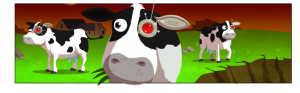
Kwame and Setsuko shoot off to deal with the bothersome bovines, while Miles and Maddison begin to delicately cut open the roof of the tractor. All is going to plan, until G.E.O. G.I.N.G.E.R points out the lone cybersheep that has wandered onto the edge of the hill. Its metal hooves send rocks tumbling. They build momentum, growing quickly into a giant wave of dirt. It all happens too fast to stop. The wave crashes down and hits with devastating power, suffocating the tractor completely…
Has the farmer’s fate been sealed? Did Miles and Maddison’s mech’s make it out? And what terrible truth lies beneath the farm on the hill? Click the link below to find all these answers in GeoSquad Chapter 2!
Mathew Sullivan, FRSA Teacher, Author and Educational Consultant