Map making is also known as Cartography, they both mean the same thing, this is, using geographical information and transforming it into a map.
As you’ll maybe know from seeing maps in school and at home, a map is a graphic which shows a simplified picture (or visualisation) of some of the features of a location/area (also known as, spatial data) it is representing.
Over the years, map making has been developed by various occupations joining forces to produce maps using COOL technology, e.g., land surveying, satellite remote sensing, aerial photography, geographical information systems, photogrammetry, & hydrography.
Map making uses skills from subjects like art, geography, science, and technology. It’s a FUN and CREATIVE profession, and there is a high demand for skilled map makers as an occupation. Map making can lead you down an avenue of lots of opportunities, including the use of GIS (Geographical Information Systems) which is a career in itself.
How to spark interest with your kids:
Start off by going out for an exploration of your local area. Pick an area with a few key objects eg a bridge, path and pond. Using objects around you, map this out using stones, sticks and grass (or whatever you can find) to create your own little nature map! Once you’ve finished remember to put back or clear out of the way the items you used.
National Geographic have created a really simple map making web page. Here you can create all sorts of different maps. Some examples of the layers you can add are the ranges of where the Big Cats are currently occupying, natural disaster hotspots, and political factors like boundaries. These can be layered as you wish, with a base map of your choice. Worth checking out with your kids if you have some spare time! Find it here.
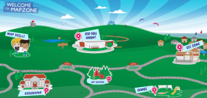
Map making comes with a whole host of topics that need to be understood… contour lines, scale, measuring distance, grid references, compasses and directions, and learning all the map symbols! Mapzone has been created by Ordnance Survey to try to educate children (of whatever age) about all of the skills mentioned above… plus lots more in other aspects of geography if you are extra keen. Have a look here.
Character Spotlight ‘Seiler’
Company Name – Seiler Geospatial.
Location – Midwest United States (we have offices in MO, KS, NE, WI, MI, IN, IL).
Why did you get involved in Get Kids into Survey? We loved the idea of promoting and supporting continuing education. The Seiler family have supported continuing survey education with equipment donations and scholarships to many of the Midwest surveying colleges and universities across the Midwest.
What do you do? Our core strength is supporting the Geospatial Industry by continuously expanding and evolving to promote and educate our customers on new technologies and industry trends. Seiler Instrument is one of the largest Authorized Trimble Distributors in the Midwest and a premier distributor for several other high quality hardware and software products. We are dedicated to our clients’ success by providing the best hardware, support, and software tools that fit their specific workflows, which ensure efficiencies and profitability. Our products include Survey Optical, GNSS, Data Controllers, 3D Scanning, Drones, Mapping GIS, Utility Survey Systems, Field and Office Software and much more. Our family owned business has a complete satisfaction purchase policy and we are committed to our customers’ complete satisfaction.
How long have you been in the Survey Industry?75 years – this year is our 75th Anniversary!
Tom Seiler, Louise Schaper, Eric P Seiler, Elaine Seiler, Rick Seiler
How did you get into the Industry? Seiler Instrument was founded in 1945 by Eric H and Dora Seiler. Today the family business is headed up by Chairman Eric P. Seiler-2nd generation, President and CEO Rick Seiler, Louise Schaper and Tom Seiler all the third generation. Kurtis Schaper, Eric Seiler III, and Matt Seiler comprise the 4th generation also working at Seiler Instrument. Our founder Eric H. Seiler helped create a company and culture of hard work, excellence in quality, service, reliability and integrity in Optical Instruments.
Did you know that Seiler Instrument/Seiler Geospatial, played an important role in surveying history as one of the original makers of surveying instruments from the United States, St. Louis area? Seiler founded Seiler Instrument Company in a small facility at 922 Pine Street, St. Louis, Missouri 75 years ago. Its primary service was the repair and overhaul of surveying instruments and microscopes. The company continued to grow and was soon manufacturing instruments designed by Eric H. Seiler. Most were Dumpy levels for the construction industry, but also included transits and theodolites. In 1956, the company outgrew its facility and moved to 1629 Washington Avenue in St. Louis and expanded again in 1968 when they moved to accommodate a complete optical manufacturing environment expansion to Webster Groves, Missouri. Today the family owns a 150,000 square foot facility in Kirkwood Missouri along with six other offices across the Midwest United States. We no longer manufacture surveying instruments, but are one of the largest resellers for Trimble Navigation in the Midwest United States.
Favourite piece of kit and why? The Trimble SX10 and Trimble X7 are the latest survey scanning and 3D modeling products to help surveyors do their job. Scanning and 3D modeling are the future of surveying, More and more people want and need to see additional data, thus with more data you can make better decisions.
Favourite survey technique and why? Surveyors use instruments to lay our property lines, housing and subdivisions and for infrastructure maps, topographic and aerial maps and much more. Surveyors are the ones responsible for maintaining land boundaries and boundaries are the basis of real property and wealth – e.g. where are my property lines and how much property do I own? Just about everything built needs a survey and surveyors are the first ones to be involved in locating and laying out what will be built. They ensure what is built is in the “right place.”
Our super awesome Brand Ambassador Ryan Swingley from Indiana tells all in this blog:
Where did you study? I did my Land Surveying studies at Vincennes University and graduated in 1999. I have maintained a close relationship with the university through out my careers and now I am an adjunct instructor there who teaches Remote Sensing for Land Surveyors.
What are the requirements to be a surveyor in your area?When I achieve my license in 2005, I was required to have 27 credit hours in college Land Surveying courses, 14 credit hours of college level math including Calculus, and 14 credit hours of college level science including Physics. I had to work under the direct supervision of a licensed Land Surveyor for 7 years and pass two national exams and one state specific exam.
How did you get into surveying? Since I was a little kid I loved to draw. I had dreamed of being an Architect as a young child and in my teen years I had decided to be a mechanical engineer. I exceled in drafting classes in high school and I was able to get a job as a construction manager for a company that did excavation and paving while I was in school. During my work I would calculate dirt quantities from plans from Civil Engineers and Land Surveyors so this got me interested in this industry. I started college in a Civil Engineering program but switched to Land Surveying after a semester because I like the hands on and outdoor activities.
If you were not a surveyor, what would you do? I am a pretty good cook so I always thought I would be a chef. I am also a pretty big fellow and I have been told I can be intimidating so being a police officer was always on my radar as well. After seeing both of those careers from a far and seeing the hardships they go through, I am glad I am a Land Surveyor.
How long have you been in the industry?I got my first land surveying job the summer of 1997 and worked near full time while going to school so I have been doing this for 23 years.
Are you part of any associations or organisations you would like us to mention?I am currently a Board of Director for the Indiana Society of Professional Land Surveyors (ISPLS) and have been the president in the past. My time with ISPLS has been very rewarding and has allowed me to help to make many positive contributions to the Indiana Land Surveying community.
Why do you want to be a GKiS Brand Ambassador?I have been working for many years to attract youth to this profession. I helped to get the Boy Scouts Surveying Merit Badge program off the ground in Indiana. GKiS is just a great tool to give ISPLS other avenues to teach children about this great profession. The average age of a licensed Land Surveyor in Indiana is 56 years old so we need youth to keep this profession alive.
Why is it important for kids to know about surveying and the wider geospatial industry?I think kids all know the importance of teachers, doctors, police officers, and construction workers but often do not know what a Land Surveyor does.I often explain to kids that a Land Surveyor had involvement in every man made physical feature on the earth. From roads to schools a Land Surveyor was there. This is important to let kids know all of the career opportunities there are but someday, those that do not become Land Surveyor may someday be consumers of land surveying products so the sooner we can shed a positive light on the services rendered by Land Surveyor the brighter our future will be.
What are you going to do as an ambassador for GKiS? We (ISPLS) have been going to as many career days as we can. Before COVID 19 I estimate that we had spoke to 700 students about a career in Land Surveying. When things get back to normal we will continue that mission but in the mean time we are seeking online opportunities to get in front of students.
What are your hobbies?I run a office that focuses on mobile LiDAR, I am an adjunct instructor at Vincennes University, I am a board member of ISPLS, I am the president of our Home Owners Association, I am instructor in 4h Shooting Sports, and I am a husband and father of four kids so I don’t have a lot of time for hobbies. When I find some rare free time, I enjoy a fine bourbon with friends, fly fishing and shooting skeet.
If you/your company had a GKiS character, what would it be?ISPLS has a character named Bengal Cat. He was created to honor a long time ISPLS board member, Don Bengel who had passed away.
What poster or resource would you like to see next from GKiS?The foundation of all things that are built in this world is the land. The land is defined by boundaries. A boundary survey is the one land surveying product that the general public is mostly likely to purchase in their lifetime and boundary surveys are often very misunderstood by those outside the profession. Often when I am talking to kids I also have an opportunity to educate parents about the boundary survey process. I would like to see a poster dedicated to boundary surveying to highlight the legal aspects of this profession.
Here at Get Kids into Survey, we have started planning and drafting ideas for our upcoming Environment poster. We thought we would share some of the resources we have come across in the recent weeks… they may be useful for lessons, home learning ideas or just for you to check out! There are a range of environmental topics discussed, some which happen naturally and others that are induced by human actions. It is our aim to include as much as possible in the poster to spread awareness of what is happening to our planet. It is so important now more than ever that everyone understands what is going on with the big sphere in which we live, so that we do not cause even more irreversible problems.
The British Geological Survey (BGS) are an organisation focused on public-good science for government and research to understand earth and environmental processes. They have a landslides database, which holds records of over 18,000 landslides in the UK, as well as a range of case studies, and then there are all sorts of construction, remediation, safety measures which can be implemented. If you want to look further into what they do, have a read of some of their research articles. They hold a lot of information on a range of topics with extreme relevance. Take a look: https://www.bgs.ac.uk/geology-projects/landslides/national-landslide-database/
Global warming is an issue that brings with it a lot of different factors. What I love about this resource by NASA, is that it is visual and easy to comprehend. NASA show a time machine back through the last 100/200 years to see the changing Sea Ice, Sea Level, Carbon Dioxide and Global Temperature changes. Another interesting side of geospatial is environmental / climate monitoring – imagine working for someone like NASA?! Please have a play with this resource that demonstrates that change needs to be made or else this pattern may continue: https://climate.nasa.gov/interactives/climate-time-machine/
Everybody remembers spending lots of time studying volcanoes and earthquakes at school. These two hazards including their monitoring is another large area of employment in high risk areas, producing hazard maps, setting incident levels and response measures /evacuation plans. MapAction is an organisation worth mentioning, they work with Humanitarian emergencies that often strike without warning, destroying lives and livelihoods within a matter of seconds. In the immediate aftermath, the challenge for those responding is to know where to start. So between 24-48 hours after a disaster the volunteer mappers are on the scene, collecting data that is vital to efficiently handling the support. “Which area has been worst affected? Where are the most vulnerable people? What has happened to roads, railways and communication networks? Where are medical supplies and where are they needed most?” are some of the most common questions that need answers to… fast! Take a look at their website, they have a lot of data sets and maps that show a variety of information from around the world:https://mapaction.org
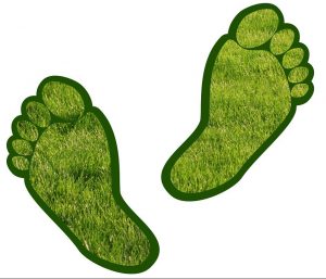
Do you know what your carbon footprint is? It is interesting to find out and amazing to see what different factors contribute the most to increasing your carbon usage. Although some may put this problem down to the larger companies, it is each of our responsibilities to make little changes and be as kind as we can to our planet. If we all start making little changes to improve, that will equal a whole lot of positives between hundreds, thousands or millions of people. Have a go at this carbon footprint calculator by the charity WWF: https://footprint.wwf.org.uk/#/
The War on Waste Documentary by Craig Reucassel has returned for a 2nd series after the first series sparked action across Australia and beyond. Craig targets a different aspect in each of his episodes, starting with the extreme issues with our food waste. Moving on to plastic waste in the oceans, the problems with fast fashion, and looking at possible solutions for these problems. Available here: https://iview.abc.net.au/show/war-on-waste/series/1/video/DO1624H003S00
I could not write this blog without including the legendary Sir David Attenborough. He has presented and helped showcase so many beautiful places around the world. In his more recent documentary (A Life on Our Planet) he highlights how the world has changed since he started and the differences over time are truly shocking. The emotion he displays in trying to make the world realise what is currently happening is hard for anyone to ignore. So, please have a watch (available on Netlix): https://www.netflix.com/gb/title/80216393
On that note, it would be great if you would like to get involved in helping educate the next generation on these topics mentioned. There is still time to put your stamp on the poster with a collection of other great brands. We need you to be able to bring awareness to our industry and all of the opportunities for great careers within it. For more information you can look on our sponsor page here https://www.getkidsintosurvey.com/get-involved/, or email us direct at hello@getkidsintosurvey.com
We look forward to hearing from you.
Character Spotlight ‘Leica Geosystems’
Written by Draco the Dragon
Company Name– Leica Geosystems
Location– We are based in a big town in the middle of England called Milton Keynes – Often called the concrete city. Our UK head office is much nicer than the cave I used to live in!
Why did you get involved in Get Kids into Survey?
Leica Geosystems and the profession of surveying have been around almost as long as dragons. Like dragons, something with so much heritage and importance is worth protecting. That’s why I’m proud to help Get Kids into Survey spread the word about surveying to the next generation of talented young surveyors and engineers. Ultimately, who can breathe new life (and fire) into the industry and set the world alight?
What do you do?
At Leica Geosystems, we design and build lots of exciting equipment that help people do all sorts of jobs all around the world. It could be a laser scanner to capture 3D images of a castle, a detection instrument that helps find dangerous objects deep under the ground or a drone that helps surveyors get a dragon’s eye view of the area they’re working in.
How long have you been in the Survey Industry?
The origins of Leica Geosystems date back 200 years when I was just a little baby. It all started with a company called Kern & Co in Switzerland. Over the next two centuries, the company grew in various forms to become what it is today. One thing that has never changed is that Leica Geosystems is still number one when it comes to surveying innovation.
How did you get into the Industry?
I got into the surveying industry almost 100 years ago when there was no such thing as drones. I used to fly over worksites and, thanks to my excellent photographic memory, could tell my colleagues exactly what I saw down to the millimetre. Today, I help Leica Geosystems by flying with their new drones such as the Leica Aibot AX20 as a quality check. If the new drones pass the Draco test, they’re ready to go out to our customers.
Funny Fact about you
I love toasting marshmallows by breathing fire. Although I burn most of them, it makes the ones I don’t burn even better.
Favourite piece of kit and why?
Apart from the drones, I love the Leica DSX. It’s a GPR instrument (that stands for ground-penetrating radar). The DSX uses radar technology to locate objects buried underground, making it very useful for utility surveys. If someone is about to dig, it’s important to make sure there’s nothing dangerous hiding below like electric cables or gas or water pipes. It’s also perfect for treasure hunts!
Favourite Survey technique and why?
My favourite survey technique is aerial surveying – with the help of the Leica Aibot drone of course. The Aibot can see everything from above just like me and it’s great fun flying around while it works it’s magic. Plus the Aibot’s photographic memory is even better than mine!
Introducing our new Brand Ambassador from Missouri, USA it is Josh Saunders…
Where did you study? Southern Illinois University Edwardsville (SIUE)
What are the requirements to be a surveyor in your area?
For the two state that I live near (Missouri & Illinois)
Have to a Bachelor’s Degree in a related science with 24 credit hours of Land Survey classes
Successfully pass the Fundamentals of Survey Exam
Work four years under a Professional Land Surveyor
Then pass the Principle of Surveying test as well as the state specific exam
***Missouri does offer some additional routes to licensure, depending on work experience and education but for the most part bachelor’s degree is the most widely route for surveyors in my area.
How did you get into surveying? A construction material supply company that I worked for 10 years closed down in 2009 at the end of a large recession in the United States. In late 2007, prior to the company’s closure, I decided to start back to school in pursuit of a degree in Construction Management. When the company I worked for closed its doors for good, I was left scrambling to find another job to support myself, my wife and my 1 month old daughter. I reached out to a close friend of mine who worked for what I thought was an engineering firm but in reality was a Surveying company. They hired me as a draftsman and the more I learned about surveying the more interested I became in it. I like finding monuments that were centuries old and while at college getting introduced to some of the upcoming technologies, like Laser Scanning (I know, I know that’s like so 2010). The college I went to offered a specialization in Land Surveying (basically the 24 hrs of surveying classes needed for licensure) to go with my Construction Management Degree, so it seemed like all my chips were falling into place. From there I finished school, worked my way through the ranks from drafter, to rodman/instrument man, to crew chief, to survey crew coordinator, to Professional Land Surveyor. That is my 11 year journey in a nutshell.
How long have you been in the industry? Since 2009
Are you part of any associations or organisations you would like us to mention? Southwest Chapter of the Illinois Professional Land Surveyors Association & the St. Louis Chapter of the Missouri Society of Professional Surveyors.
Why do you want to be a GKiS Brand Ambassador? For the last 5 or 6 years I have been a proponent of introducing elementary, high school, and college students to Land Surveying.
Why is it important for kids to know about surveying and the wider geospatial industry? There is a huge disparity for Land Surveyors in the United States and I assume all over the world. Rather than just let a historic profession die or be absorbed by another profession like civil engineering or geography. I like to see if I could generate interest with students by introducing them to the most exciting and technologically loaded profession out there.
What are you going to do as an ambassador for GKiS? I am going to get the next generation of surveyors fired up about land surveying. That is a little more difficult now with the COVID19 restrictions in place but just as with most surveyors I am adapting to the environment. In October, I am attending my first ever virtual career fair, so I am excited to see how that turns out.
What are your hobbies? I enjoy camping, boating, travelling, fishing, and most things with friends and family.
If you/your company had a GKiS character, what would it be? Either a techy kind of surveyor wearing AR glasses flying a drone while riding on an automatous vehicle (just spit balling some ideas here) or a futuristic space surveyor (see the answer for the next question).
What poster or resource would you like to see next from GKiS? With space exploration getting closer and closer, I think it would be neat to see a poster with surveyors on Mars helping with the exploration of the planet with all of our equipment (that is something I talk about with students on where the profession could be going).
Bats are protected by law, meaning that you cannot disturb, damage or remove a bat in its natural habitat. therefore, if you are planning a project which may have the chance of disturbing a bat, it is a requirement to get a bat survey done to the area. This may be a planning application, a barn conversion, removal of a hedgerow, introduction of wind turbines, and so much more. An experienced bat surveyor will not only listen for bats during the bat survey season (May-September) they will also assess the area/building for potential signs of their presence, including potential roosting sites. If there is bat presence this does not mean that the project cannot go ahead, it means the correct measures need to be put into place in order to ensure the bats safety. There are a range of mitigation and compensation methods that can be enforced, from moving the location of the project to creating, restoring or improving roosts (and replacing any that will be damaged or removed).
I must admit, I wasn’t familiar with bat surveying until the end of my time at University, when I began to search for jobs. Lots of jobs ask for experience within the sector, which is very hard to have completed when you are still a uni student. Therefore, quite a few companies open up spaces for people like me to come in and do freelance surveying! Any experience is good experience, you may really enjoy something that previously hadn’t appealed to you, whilst gaining lots of new skills.
The first evening I arrived on site for 18:15 just before the sun began to go down. Here I was met with 2 others, the leader and another freelancer. We were briefed on what we had to do… study an abandoned house to see if any bats were roosting in there. Each of us having a different side of the house to observe for the next two hours.
We were each equipped with a clipboard, site map, data collection sheet, bat detector and a torch. When we saw a bat we would jot down the time heard, which frequency we heard them best at, and if seen mark their location/direction on the map. The leader had set up some bat recording devices around us so that she could revisit the data and properly identify the bats through their calls. She does this by listening to the data at the times we recorded hearing a bat. This limits the chances of errors as the bats are identified correctly by a professional.
On the outcome of this survey we could not see any evidence of them roosting in the building. From all sides of the site we heard and saw multiple bats however they were either commuting or feeding nearby. This matched the data from 5 years ago when the survey was last conducted in this location.
Transect Survey
For this survey I arrived on site at 18:00 as the nights started to draw in faster as we approach winter. Again there were three of us taking the surveys, however, this time the site included a compound and two large fields with developments nearby. The aim of this survey is to walk around the designated section, to see if we could see/hear any bats along the transect.
Similar to the last survey I was equipped with a clipboard, site map, data collection sheet, bat detector and a head torch as I’d be walking around.
This survey wasn’t as successful with only 3 recordings of bats from one corner of the site. Maybe due to it being an open field so there were less places for the bats to hide and fly between. Still an enjoyable experience gaining some fun skills using new equipment and techniques.
Equipment used:
Bat Detector- bats hunt for insects at night, using a high frequency system called echolocation. Bat calls are usually pitched at too high a frequency for humans to hear, but they can be heard using bat detector devices.
Data Collection Sheet- to record all sightings including frequency, time and location.
Pencil- to write down your observations.
Map- of the site in order to record sightings of bats (and of the transect route if doing a transect survey).
Hi-vis- So people can see you whilst you are working.
Watch/phone- in order to tell the time.
Bat recording device- monitor the ultrasonic echolocation calls of bats for species identification and activity measurement, data to look back on after the survey.
How can you get involved?
There will be lots of companies around your area that carry out surveys like this. Mine was through Smeeden Foreman who are local to me, they specialise in landscapes, ecology and arboriculture. If you are UK based it might be worth checking out these websites for more information about volunteering https://www.bats.org.uk/ and https://batsinchurches.org.uk/get-involved/volunteer-bat-survey/. Bat surveys need to be renewed due to the seasonal changes of where bats roost… meaning that surveys need to be done every year/two years to ensure the site is still ok to have work done.
Surveyors use a wide variety of tools and equipment in their day to day work; it will vary depending on the type of survey being done, here’s a few examples:
‘Drones’ are unpiloted aircraft or spacecraft. Surveyors use them because they provide a fast, safe and cost-efficient way to survey at height.
‘Theodolites’measure precise horizontal and vertical angles for the purpose of triangulation. They can workout the location and distance of a point through the formation of triangles.
‘Total stations’ modern theodolite’s, these are currently the most commonly used tool for surveyors because of its accuracy. The data that is collected and processed can be downloaded for further processing. They do angles and distance measurements (EDM) but can also have cameras/scanners and even GNSS units built into them now too, as well as being robotic (they can spin themselves around to find you and the pole/prism).
‘Measuring wheels’ are used for quicker and lower accuracy surveys of long distances by rolling it from the start to end point. You may have seen a person using one of these near a road, or in your school playground or on sports pitches.
‘Prism Poles’ are used to measure the elevation of existing ground or grade when used in conjunction with a survey level such as an Automatic Level, Transit Level, or Laser Level.
‘Surveying Prisms’ are a corner cube or retroreflector, usually attached to a surveying pole and utilized as a target for distance measurement. Modern alternative to the measuring wheel.
‘Surveying Tripods’ are a special tripod built to support surveying instruments, such as theodolites, total stations, levels, prisms or transits
‘Automatic levels’ are optical instruments used in surveying and building to transfer, measure, or set horizontal levels. The level instrument is set up on a tripod.
‘Digital levels’ offer fast and accurate readings utilising a bar coded staff. They offer the opportunity to record readings at the touch of a button as well as displaying the distance to the staff.
‘Chains’ are one of the oldest and simplest methods of making measurements. Distances can be measured using the chain’s length. Angles can either be measured directly or calculated by moving one end of the chain by a known distance.
‘Prismatic compasses’ can measure angles effectively. This is typically combined with a chain to take distance measurements.
‘Clinometer’ (or inclinometer) is an instrument for measuring angles of slope (or tilt), elevation or depression of an object with respect to gravity.
‘Global Navigation Satellite System’ (GNSS) refers to a constellation of satellites providing signals from space that transmit positioning and timing data to GNSS receivers. The receivers then use this data to determine location. By definition, GNSS provides global coverage. Examples of GNSS include Europe’s Galileo, the USA’s NAVSTAR Global Positioning System (GPS), Russia’s Global’naya Navigatsionnaya Sputnikovaya Sistema (GLONASS) and China’s BeiDou Navigation Satellite System.
‘Disto laser measurers’ are ideal for quick, easy and precise measurements of distances such as length and volumes with the press of a button, even in inaccessible places. These save money and time as well as improve the accuracy of measurement on site.
‘Ground penetrating radar’ (GPR) is a geophysical survey method that uses pulses of electromagnetic radiation to image the subsurface. It provides a non-intrusive and non-destructive method of surveying the sub-surface. Therefore it is a useful survey technique to investigate many types of materials.
‘Laser Scanners’ deliver a high definition output and can be in 3D. They can be used alongside traditional surveying equipment or as an alternative to total stations. Laser scanning carries lots of advantages as the surveyor can quickly and easily collect a large amount of data over a short period of time. This data is the combination of millions of data points which, when put together, forms a point cloud image of the survey area. Data can be interpreted by computer aided design (CAD), building information modelling (BIM) or geographic information system (GIS) software.
*information gathered from a mixture of websites and checked over by surveyors.
We use cookies on our website to give you the most relevant experience by remembering your preferences and repeat visits. Read More.
This website uses cookies to improve your experience while you navigate through the website. Out of these, the cookies that are categorized as necessary are stored on your browser as they are essential for the working of basic functionalities of the website. We also use third-party cookies that help us analyze and understand how you use this website. These cookies will be stored in your browser only with your consent. You also have the option to opt-out of these cookies. But opting out of some of these cookies may affect your browsing experience.
Necessary cookies are absolutely essential for the website to function properly. This category only includes cookies that ensures basic functionalities and security features of the website. These cookies do not store any personal information.
Any cookies that may not be particularly necessary for the website to function and is used specifically to collect user personal data via analytics, ads, other embedded contents are termed as non-necessary cookies. It is mandatory to procure user consent prior to running these cookies on your website.
Translation Options Hotsheet Download
Please fill out the form below to access our Translation Options Hotsheet:
Monopoly Sponsor Info Sheet Download
Please fill out the form below to download our Monopoly Sponsor Info Sheet Download:
Autumn Poster Hotsheet Download
Please fill out the form below to access our Poster Hotsheet:
Summer Poster Hotsheet Download
Please fill out the form below to access our Poster Hotsheet:
Spring Poster Hotsheet Download
Please fill out the form below to access our Poster Hotsheet:
Poster Hotsheet Download
Please fill out the form below to access our Poster Hotsheet:
Re-Print Hotsheet Download
Please fill out the form below to access our Re-print Hotsheet:
Winter Poster Hotsheet Download
Please fill out the form below to access our Poster Hotsheet:
Homework Project Info Pack
Please fill out the form below to access our Homework Project Information Pack:

 Company Name
 In 1956, the company outgrew its facility and moved to 1629 Washington Avenue in St. Louis and expanded again in 1968 when they moved to accommodate a complete optical manufacturing environment expansion to Webster Groves, Missouri. Today the family owns a 150,000 square foot facility in Kirkwood Missouri along with six other offices across the Midwest United States. We no longer manufacture surveying instruments, but are one of the largest resellers for Trimble Navigation in the Midwest United States.
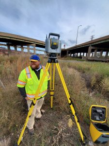 How did you get into surveying?
  Why do you want to be a GKiS Brand Ambassador?
  If you/your company had a GKiS character, what would it be?
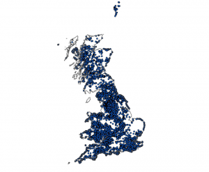 The British Geological Survey (BGS) are an organisation
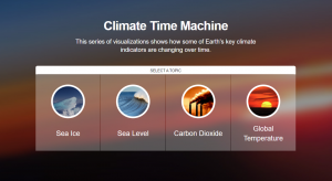
 Do you know what your carbon footprint is? It is interesting to find out and amazing to see what different factors contribute the most to increasing your carbon usage. Although some may put this problem down to the larger companies, it is each of our responsibilities to make little changes and be as kind as we can to our planet. If we all start making little changes to improve, that will equal a whole lot of positives between hundreds, thousands or millions of people. Have a go at this carbon footprint calculator by the charity WWF:
 Why do you want to be a GKiS Brand Ambassador? For the last 5 or 6 years I have been a proponent of introducing elementary, high school, and college students to Land Surveying.
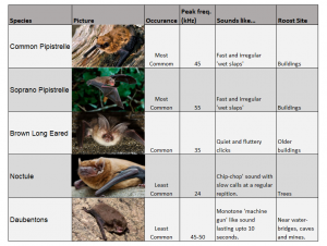
 We were each equipped with a clipboard, site map, data collection sheet, bat detector and a torch. When we saw a bat we would jot down the time heard, which frequency we heard them best at, and if seen mark their location/direction on the map. The leader had set up some bat recording devices around us so that she could revisit the data and properly identify the bats through their calls. She does this by listening to the data at the times we recorded hearing a bat. This limits the chances of errors as the bats are identified correctly by a professional.
 For this survey I arrived on site at 18:00 as the nights started to draw in faster as we approach winter. Again there were three of us taking the surveys, however, this time the site included a compound and two large fields with developments nearby. The aim of this survey is to walk around the designated section, to see if we could see/hear any bats along the transect.
 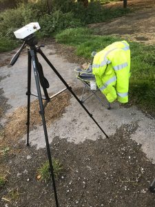 Bat Detector- b
 ‘Surveying Tripods’ are a special tripod built to support surveying instruments, such as theodolites, total stations, levels, prisms or transits
 ‘Disto laser measurers’ are
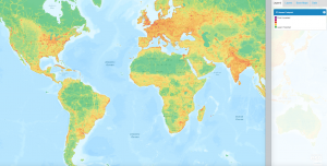
 National Geographic have created a really simple map making web page. Here you can create all sorts of different maps. Some examples of the layers you can add are the ranges of where the Big Cats are currently occupying, natural disaster hotspots, and political factors like boundaries. These can be layered as you wish, with a base map of your choice. Worth checking out with your kids if you have some spare time! Find it here.
 Map making comes with a whole host of topics that need to be understood… contour lines, scale, measuring distance, grid references, compasses and directions, and learning all the map symbols! Mapzone has been created by Ordnance Survey to try to educate children (of whatever age) about all of the skills mentioned above… plus lots more in other aspects of geography if you are extra keen. Have a look here.