

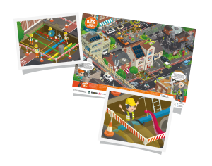
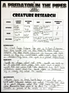
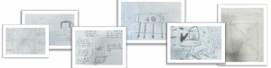
 The long limb looming from the sewer pipe set the group’s imaginations racing – especially when they heard reports that one of the utilities workers had been pulled into the pipeline and had disappeared, along with any trace of the mysterious creature.
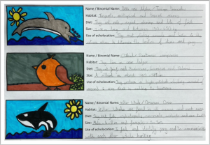 Having completed their creature research, the group turned their attention to a different set of interesting animals: those that use echolocation.
 What do you do and what company do you work for? So I am the Strategic Partners Manager at Built Intelligence (sounds fancy but it’s not!) The company is a cross between a training company and a software company, providing training, learning, and contract software solutions to the construction industry.
 Why do you want to be a GKiS Brand Ambassador? Personally, having 2 daughters I have always felt it was difficult for kids to make informed choices about options and careers when there is limited careers support and they don’t know what the choices are out there! I got involved in setting up a regular careers slot at my local school and dragged along a surveyor to talk about his career and it escalated from there really. I also signed up to volunteer through a local organisation and go into local schools to take part in assemblies and have done a couple of ‘What’s my Line’ where kids ask questions to a panel to guess asking what our jobs are!
Please fill out the form below to download our Monopoly Sponsor Info Sheet Download:
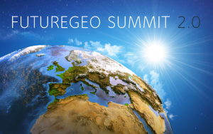
FutureGeo 2.0 Report compiled by Erin Hull
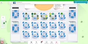
This week Get Kids into Survey were lucky enough to be a part of ‘a networking event with a difference… an opportunity to connect, talk, and change the future of GeoScience’ organised by our Brand Ambassador Tom Backhouse.
Brought to us through DigiLounge virtual platform there were 8 virtual floors each having a different theme, there was definitely lots to get involved in. GKiS were involved in getting the conversations started on Floor 6- GeoScience through Geography and STEM. Elly was one of the FutureGeo ‘champions’ and spoke to many of the attendees, all having different opinions and experiences to share on the topic.
As an attendee I (Erin Hull) had a mooch around a couple of the floors to see what different tables were talking about. There was so much going on that I will have barely touched the surface with my conversations. The discussions touched upon were based around these topics:
Diversity, difference and equality in geoscience
Communicating geoscience
Utilising emerging technology in geoscience
Water and geoscience
The energy and material transition
Inclusivity and opportunity in geoscience
Exploring the decline in University enrollment
There were a lot of fears and problems identified at the start of the event by four intro speakers; Chris Jackson, Michael Kehinde, Hannah Goodlad, Catherine Owen and George Whitehouse. We have summed up some of their key points;
The future of geoscience is very important, the community needs to keep engaged and have the opportunity to link up, share ideas, and bring everyone together because we are part of the solution to many problems. At the moment the industry does not have many opportunities to connect together.
There is limited diversity, racially and ethnically within the industry. With the spotlight currently on this barrier, now is the time to tackle this and be more inclusive.
Water availability worldwide is a massive problem. 1 billion do not have access to safe water, millions die each year because of this. When water is too much OR too little it causes livelihoods to be ruined. Geoscientists need to work with other professionals as part of the force to enhance and save our planet from destruction.
The public image of us is viewed through a narrow lens
Geology could be left out of energy transition when we need to be involved. This brings us drive and motivation to let geology find its place. Where the community will connect and grow as our purpose is clear, as geologists we are all about the EARTH, one vital part of our existence.
Younger people have limited opportunity in the industry, requiring experience and masters degrees, something needs to change which allows an opening for the younger generation to get involved. Inclusivity means everyone should be on a level playing field, not only the younger generation which has been highlighted but those with disability or from different language backgrounds too.
Through talking about fears and problems within the community, it brings things to light that might not have been thought about before. This gives us the opportunity to tackle these issues head on, by opening conversations about them, starting discussions, leading to creating methods to combat them so they are not a problem in the future.

At the next stage of the event everyone could move around the floors and tables to network amongst each other. Although I was only involved in a handful of conversations I still learnt a lot and thought I would share some of my discussion outcomes:
Many universities have begun to close their Geology courses due to lack of interest and decreasing enrolment over the last few years. Discussing the reasoning behind this it is thought there are a few reasons behind it. Firstly, there is a lack of understanding of the terminology used, maybe potential students are put off by words or phrases that they have not gained an understanding of. Students may be unaware that they are studying geology in some of their subjects as it is present in physics, chemistry, biology and geography; however, as the word geology is not used the students do not realise they are aspects of their learning journey already. The diversity of the subject needs to be more exposed and the catchment needs to be based on younger children rather than just before they apply to university.
Career advice is definitely lacking, with students being directed to being conservationists or consultants when asked about careers in geology. This lack of knowledge is believed to be a huge limiting factor in why children have not considered geosciences as their career. There should be a wider outreach which should involve the community as a whole, teachers, parents and the students. They all play a massive role in influencing future choices because if they are not aware of an opportunity then how can they be expected to share that or speak out about that career to others. The careers process definitely needs an update as people are interested, they are just misinformed. A good example of this is how civil engineering has updated their process of exposing the industry and employment options.
We should be aware of how we portray the Geosciences to show the full range of what Geoscientists do, showcase this and share what you do so others can learn. When recruiting, look beyond local networks to ensure fresh talent is applied. Linking to this, it is recognised that Geology is an expensive degree, so change needs to occur to mitigate this limiting factor. This may be by introducing more on the job training to reduce the cost/need to do an MSc similar to the engineering careers.
Geosciences can grow by encouraging mentoring schemes at all levels from school, through degrees and into industry. Funding research into effective initiatives to reduce the diversity gap, to allow evidence based action, proving that the industry can and will grow and be accepting of everyone. For this to occur geoscientists cannot act as gatekeepers which discourages students from taking a Geoscience degree based on our ideas of what a geologist looks like. Stereotypes are something that need to be reworked to make sure no one feels unwelcome if that is their talent. Recognising that we need to be aware of our own privileges and the benefits they bring and so act as allies and advocates for change!
Inclusivity within the community brought up some interesting stories of women in other countries being unable to step foot on site, leading us to believe that we are very lucky here in the UK, although still a way to go to make everything fair for all. Women in Mining are working on including everyone and getting more women especially, into the industry. An outcome of this conversation was that people shouldnt be afraid to put themselves forward for roles. Most associations are making an effort to be fairer, not needing to be nominated for positions any longer. Being a volunteer allows you to help on a subject that you may be passionate about, and can help to teach others about it. We need more of this and people stepping up to bring their own ideas to the table in order to continue to better the community and get more inclusivity.
Recruitment issue and what we can do about it. From Elly’s floor, she explains that we all know that there is a recruitment issue in our industry, whether that being into a direct job role or into the relevant University degrees. So the question is, how do we change this? And the answer is simple. Through primary and secondary education, to the teachers and parents. However the difficulty we all face is how to get our material into schools, used by teachers and done so where the next generation doesn’t just have access to this world, but is inspired and wants to take the next steps to get involved. “It was while we were discussing this that I had a bit of a lightbulb moment. Virtual conferences are here to stay, there’s no doubt about it. So why not do a virtual conference for students directly? I know we have conferences for teachers which is great but we need to connect industry directly to students. Subjects need to be more career aware, career focused and that’s where we need to link education and industry.
We have a lot of work to do but luckily our industry is a passionate one and I know we can make a difference if we work together.
There are some initiatives in place that you can get involved with today;
Firstly, a movement mainly on twitter is #AskAGeo where anyone can use the hashtag and a geologist will answer any queries you have, however big or small. It was identified that social media needs to be maximised so new ideas like this are a great start.
On Instagram there is cool hashtag which shares what geologists get up to in their jobs called #FieldWorkFriday. A great way to enlighten those who are not familiar with what geoscientists do, now made available on a very popular and easily accessible platform.
ECMWF host a lot of seminars for GeoScientists and is a large European organisation.
Geopoetry event held October 1st 2020 – Patrick Corbett (The Geological Society) with Scottish Energy Forum sponsorship.
Geoscience for the Future Poster, which incorporates the Sustainable Development Goals.
Earth Science Teachers Association (ESTA) who do an annual conference to help support earth science teaching through geology, geography, and the sciences.
GeoBus is a free outreach programme run out of the Earth Science department of UCL, usually doing hands-on science for secondary schools. To fit with the current climate they are now hosting FREE virtual STEM workshops!
 Get Kids into Survey- become a Brand Ambassador. Use the GKiS resources and share with your local school.
Get Kids into Survey resources for primary and elementary school level – targeting the wider population, making primary school children aware of the industry through exciting educational resources! With new lesson plans being released to compliment the posters, this is only the start and we can’t wait to see what else is to come.
*If there is any more information to add please contact erin@getkidsintosurvey.com and we will add it to this document. Thanks.