Let us introduce you to our latest Brand Ambassador; Assumpta Jebichii, a final year student pursuing Geospatial Information Science at Maseno University, Kenya. Assumpta is dedicated, detail oriented and an approachable expert of GIS, remote sensing and survey, who attributes success to outmost discipline and determination. She has excelled in areas such as Geospatial software management (ArcGIS and AutoCAD civil 3D), data collection and research.
She is passionate about making a change in her community and the world in general by using GIS as a tool in solving real world problems, hence providing long-term solutions. “I believe that GIS and Survey is a powerful tool and it should be embraced by all.”
Assumpta is a a member of Women in GIS, GIS chapter (Maseno University), PASAMU (Planningassociation of students of Maseno University) and a former GIS/Survey Intern of the Kenya National Highways Authority (KeNHA).
Do you attend Career Fairs?
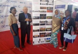
The annual RIC AfriGEO symposium at the Regional Centre for Mapping of resource for Development (RCMRD).
I got the opportunity to attend this conference that brought together decision makers, Geospatial engineers, surveyors and students across the globe. It was aimed at showcasing the importance of spatial data in finding solutions in sectors such as, governance, land administration, healthcare planning, utilities etc.
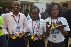
LAKE BASIN INNOVATION AND INVESTMENT WEEK(LBIIW)
Kid’s Hackathon
This conference was guided by the theme, “Promoting innovation for sustainable development”. One of the core activities that I got to volunteer on was the Kids hackathon session, whereby kids from the lake region were being empowered on how to make toys and the use of robotics and also on how they can use their talents to bring solutions.
What is the requirement to be a surveyor in Kenya?
Under the Constitution of Kenya for someone to be able to practice surveying fully as a career, he/she must be licensed and should be a full member of ISK (Institution of Surveyors of Kenya) or he/she should work under a licensed surveyor.
How did you get into surveying?
I love maps because they do speak in a unique way. Maps can convey information in a way that no human eye can see, through interpretation and visualization. My passion for space and environment saw me take Geospatial information science and surveying as a career, because it gives me an opportunity to map out phenomena that have spatial characteristics and also to discern spatial relationships that do exist between features and why these relations happened.
I have grown my career through immense support and guidance from my lecturers and my mentors who are in the same industry, who have constantly empowered and mentored me to be where I am today.
How long have you been in the industry?
I have been in the Geospatial and survey industry for 1 year and half.
What Associations and Organisations are you apart of?
Maseno University
Women in GIS
PASAMU(Planning association of students of Maseno University)
GIS chapter(Maseno University)
Why do you want to be a GKIS Ambassador?
Get Kids into survey is a platform that instils core career values to the younger generation by empowering and mentoring them. I would like to be an Ambassador of this organization so that I can be a change to the younger kids. I would like to encourage and produce Geospatial engineers and surveyors from this generation and also from the disadvantaged groups in the society.
Why is it important for Kids to know Surveying and the wider Geospatial industry?
Geospatial information science and Surveying is a human interactive discipline that puts into consideration the opinions and the need of the community through Participatory GIS (PGIS).
It is important for kids to know Surveying and GIS because it will shape them to be key players, decision makers and critical thinkers in solving problems that are felt in the contemporary world by providing long term solutions by the use of spatial data.
Through this, they will also get to have a greater understanding on planet earth and on the importance of conserving the natural environment by use of maps and spatial data as a platform of making critical decisions pertaining the same.
What are you going to do as an ambassador for Get Kids into Survey (GKIS)?
As a Get Kids into Survey ambassador, I plan to engage all primary school and secondary school children in my community. I would like to be a change by empowering and mentoring them on core career values especially on what Geospatial Information Science and survey entails.
I believe that out of this, many young children will feel empowered by guiding them on the importance of using their God given talents effectively and on how to make wise career choices when the right time comes.
What are your hobbies?
Travelling to new places
Reading a book
Cooking
Environmental conservation
If you could choose a Get Kids into Survey character, what would it be?
The character would be a Bear representing a Geospatial analyst. The character will represent the day to day roles of a geospatial analyst, who uses GPS for spatial data collection and maps for representing features.
What posters and resources would you like to see next from Get Kids into Survey (GKIS)?
GeoSquad
Utilities poster
Forestry posters
Crime scene investigation posters
Anything else you would like to mention?
“The future of our nations and the next generation is our key responsibility. A nation that invests and takes care of its children and their welfare is set to prosper”.
Character Spotlight ‘RIPRO Corporation’
Company name: RIPRO Corporation , Japan
Location: Okayama city, Japan. The head office is located about 600 km from Tokyo and about 150 km from Hiroshima.
Why did you participate in Get Kids into Survey?
We want to tell the world’s kids about the importance of survey markers. To help them understand why survey markers exist and how they help protect everyone. To encourage kids to explore and find survey markers… You can even come across them as you walk to school!
What do you do?
Survey markers have been protecting our lives since the days of your grandfather and grandmother; as well as your great-grandfather and great-grandmother, going back hundreds of generations to ancient Egyptian times. Survey markers have long watched over the past history and future of time. They will spend their lives at their installation point and will stay there forever, watching over you. RIPRO manufactures survey markers that provide support for your life and to help land surveyors.
How long have you been in the survey industry?
RIPRO is nearly 50 years old, founded in 1973. Looking at the plastic trash that was thrown away 50 years ago, we started thinking that we could recycle waste plastic into something useful. That was when the idea came to light, before this survey markers were mostly wooden stakes, but we thought in the future people will eventually run out of natural resources!
It was said that they should be changed to a recycled plastic stake marker that can be used for a long time, is light, easy to carry and stronger. Plus the discarded plastic was regenerated cleanly to re-invent the surveying stake. These days, we are working to develop a new survey marker for the future by evolving to an information ECO stake marker. An information survey marker with IT technology which will talk to you through smart phones in the near future.
How did you get into the industry?
The trigger was the emergence of environmental pollution problems in the 1970s in Japan. We came up with a survey stake marker with the consideration of the utilization of discarded plastic. In Japan surveyors were pleased that they were light and easy to carry and difficult to pull out. We entered the market by using earth-friendly recycling and introducing earth-friendly surveying!
Interesting fact about the you
There was a big earthquake in Japan in 2011. At that time, a big tsunami swallowed the city and a lot of other things, it was a very sad time for us. What the tsunami swallowed arrived as garbage on the American west coast 5000 miles away. An American whale-sighting captain found a small 1 foot long survey marker stake floating alongside his dock. There was a Japanese character on the stake marker, and we were impressed that it had crossed 5000 miles from Japan due to the tsunami. I was able to visit him and take the marker he found back home to Japan.
The news about the Japanese plastic survey stake marker was seen by a Seattle TV station and they broadcast a story about it on TV. Our American friend saw it, recognized it as a RIPRO stake marker and contacted me. Why does the stake that keeps an eye on everyone’s feet for many years swim to America? !! We were surprised. We immediately went to America to pick up a stake marker. The American Orcas Island captain was very surprised we came and kindly said for me to return to Japan safely. The tsunami is a sad time in history. However, this swimming stake marker that crossed over pacific ocean connected the United States and Japan, creating friendship beyond the earthquake and tsunami sadness. One Survey stake marker connected people and brought peace. It is a really interesting small survey marker adventure story which has been made into a book. You can read the story HERE which is called ‘LITTLE ORCA’S 5000 MILE ODYSSEY’.
Favourite piece of kit and why?
Information stake marker. For the future, we are developing and manufacturing an information stakes marker that adds information to an ordinary stake marker. Many people can see the information about the land through the stake marker on their smartphones, passively and actively. From the stake marker it can tell you about the history of the land, the history of people’s lives, maybe even point out delicious nearby shops too.
Favourite Survey technique and why?
Recently, due to weather climate variability problems, especially in Japan, there have been landslides in the mountains due to heavy rainfall. The stake marker that conveys active information monitors the movement of the mountain, by inserting a sensor in the head of the stake marker and alerts people to protect them from a landslide disaster. The monitoring measurement technology is from high-tech information stake markers made from recycled plastic waste. These contribute to disaster prevention and sustainable life in the sustainable development goals (SDGs).
How did you choose your character and what does it represent?
The character represents a conversation between a survey stake marker and a person. I (Kengo Okada/CEO) was born in a stake marker factory. When I was a kid, I was surrounded by many stake markers in the warehouse and they entertained me in the night when I was lonely.
So, the person’s name is Kui- Japanese language for Stake Marker. I am very happy that the stakes have information and will be useful for disaster prevention and environmental activities. The stake marker name is Orcas! That is the stake marker that swam across the Pacific Ocean.
I hope that one day the stake marker and people can talk to each other all over the world!
Surveying Everest to the practical applications of GIS involving Covid19.
As a Geospatial community we are very lucky in the way that Covid-19 hasn’t had a drastic impact on our workload, compared to other industries (such as hospitality and tourism). We have been checking out some recent blog posts and compiled a few of our favourites. A mixture of topics for you to dive into…
Mapping tools for COVID-19 response
Responding to the covid-19 pandemic by observing the data and understanding the trends. This is how ArcGIS plays its part in the response, firstly it can monitor the current inventory of personal protective equipment (PPE) and the capacity and status of facilities. With other uses including monitoring the surge in graphs, managing testing sites by looking at demographics, and using StoryMaps to quickly communicate the changing situation to others. Read the full article here:
Linking to the previous article this demonstrates how the vaccination programme can be coordinated. It is getting launched in the UK very quickly, so ensuring the vulnerable people have access to the vaccine is vital, which requires a lot of planning. This article explains the possible uses of GIS with the tools within it, and their practical applications to the programme. Worth a read if you are interested, click here.
Combining light and sound to see underwater!
With the ocean covering about 70% of the earth’s surface, it’s shocking to know that only a small proportion of that has been subject to high resolution mapping. Mapping underwater however, is not easy. “The main barrier has to do with physics: Sound waves, for example, cannot pass from air into water or vice versa without losing most—more than 99.9 percent—of their energy through reflection against the other medium. A system that tries to see underwater using soundwaves traveling from air into water and back into air is subjected to this energy loss twice—resulting in a 99.9999 percent energy reduction”. Read more to discover how the Photoacoustic Airborne Sonar System works on this blog.
Which school subjects are involved in mining?
This is a must see video especially if you have kids in school and want to know how different subjects link to different careers. Might spark some new interests… Watch now
Mount Everest’s Changing Height
Now, you may have already seen this on the news as this story has been very popular with the press! Measuring Mount Everest! It’s grown?? By nearly a meter, the new official elevation announced on December 8 by Nepal and China. The two teams coordinated the results of their 2019 and 2020 surveys of the famous mountain to agree on the new elevation— 8,848.86 meters or 29,031.69 feet (height above sea level). Read it in full here.
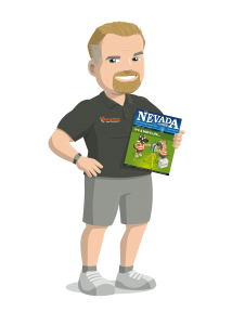
Ambassador Spotlight ‘Trent Keenan’
Meet our Brand Ambassador Trent Keenan from Nevada, USA.
Where did you study? I studied AutoCAD in Phoenix, AZ before becoming a land surveyor.
What are the requirements to be a surveyor in your area?For the State of Nevada, we require a bachelor’s degree in Geomatics
How did you get into surveying?My story is a little different than everyone else, I was in High School driving down the road and saw a couple of surveyors walk out to the intersection and thought, that is cool… A few days later and I am researching what it will take to become a land surveyor. And I am glad I did. 😊
How long have you been in the industry?This is my 25th year in the land surveying profession!
Are you part of any associations or organizations you would like us to mention? I have been involved in our local and state chapters of the Nevada Association of Land Surveyors since 2007. I am the past president of the local chapter 2011, and past president of the state association 2015, I am the current Nevada director on the Western Federation of Professional Surveyors (WestFed) and lastly, I am the current editor for our State Association quarterly publication called The Nevada Traverse.
Why do you want to be a GKiS Brand Ambassador?I am heavily involved in outreach for our local and state association as well as the chairman for outreach on the WestFed board, so its only fitting to use the GKiS brand to help promote the profession and attract the under generation!
Why is it important for kids to know about surveying and the wider geospatial industry?There is a few reasons, but the main one would be to help kids understand that there is a career that will allow them to work in a lot of different fields all at the same time, using history, law, math and working indoors or outdoors all in the same day. The profession requires a lot of working knowledge in a lot of different subjects.
What are you going to do as an ambassador for GKiS? Help promote the GKiS brand, educate and mentor as many kids as possible through school career fairs, class presentations. And most of all bring awareness to the profession!
What are your hobbies? Photography, Running ½ Marathons, Biking, Hiking & Golf 😊
If you/your company had a GKiS character, what would it be? Already have one. Its myself and my two dogs!
What poster or resource would you like to see next from GKiS? Well Las Vegas of course!
Surveying through history
Surveying is one of the oldest professions in the world. It has occurred since humans built the first large structures.
Below are some examples, in history, of surveying:
The almost perfect square shape of the Great Pyramid of Giza, built c. 2700 BC, is evidence of the Egyptians’ use of surveying.
Stonehenge (c.2500 BC), in the South of England, was set out by prehistoric surveyors using “geometry” – from the Ancient Greek meaning “earth” “measurement”
Eratosthenes was – amongst other things – one of the most important land surveyors of all time!Even though he lived over 2000 years ago – way before the time of scanners, satellites and sonar – he managed to work out the circumference of the Earth, the tilt of the Earth’s axis, and the distance from the Earth to the Sun!
He even made a map of the world with parallels and meridians, showing that he understood that the Earth was a sphere! And he worked all this out through measuring and comparing distances and angles on land. We think that makes Eratosthenes a Geo Survey Legend!
The Romans recognised land surveying as a profession. They established the basic measurements under which the Roman Empire was divided.
In the medieval period, groups of residents walked around their village to remind themselves of the boundaries. The group included people of all ages, the younger ones were there to make sure the ‘communal memory’ lasted as long as possible.
In 1086, in England, William the Conqueror commissioned the Domesday Book. It recorded the names of all the land owners, the area and quality of land they owned and specific information of the area’s content and inhabitants.
Mount Rushmore 1927: These giant sculptures were carved into the granite face of Mount Rushmore by Gutzon Borglum to commemorate four great American presidents. Three of them were also surveyors!
George Washington was made a county surveyor at the age of only 17 – just one year after going on his first survey expedition! He completed around 200 surveys and mapped about 60,000 acres of land.
Thomas Jefferson came from a surveying family. He used his knowledge to help him make deals to buy land that quadrupled the size of the growing United States in the 18th Century.
Abraham Lincoln managed to become a surveyor after only six weeks of study. He would later use this knowledge to help him buy and sell land and invest in local areas.
Although the fourth president on Mount Rushmore, Teddy Roosevelt, wasn’t a surveyor, he did do some mapping in the Amazon!
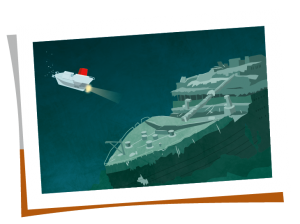
North Atlantic Ocean 1985: An underwater archaeologist named Robert Ballard in his submarine (‘Alvin’), exploring the North Atlantic Ocean floor at a depth of over 12,000 feet… in which he discovered something incredible: the wreck of the Titanic! Ballard had previous experience mapping underwater regions using sonar technology, but this find would put him on the map as an intrepid underwater explorer! However, the really cool part of Ballard’s story was that his mission to locate the Titanic was actually a cover-up for a secret military operation to find and explore the USS Thresher and the USS Scorpion, two American nuclear subs that sank in the 1960s! This sneaky spy stuff makes Robert Ballard a super cool surveyor!
Mount Everest 1999: Bradford Washburn was an expert cartographer, or map-maker, and the images he captured of remote and dangerous places are still used by climbers today. He used to hang out the side of a plane while his wife piloted; she would make daring fly-overs of treacherous areas while he snapped pictures from angles that no-one else dared to try and reach. In 1999, Washburn updated the official height of the world’s tallest peak – Mount Everest – to 8850m. He used special survey equipment to help make sure this reading was as accurate as possible… and he was 70 years old at the time! That makes Bradford Washburn a certified survey legend.
Ambassador Spotlight ‘Dave Dagostino’
Introducing Dave Dagostino a fabulous Brand Ambassador who does a lot of work for us!
What do you do and what company do you work for? CEO and owner of Dagostino Geospatial, Inc.
Are you part of any associations or organisations you would like us to mention?
Member: American Society of Civil Engineers (ASCE)
Member: American Society for Photogrammetry and Remote Sensing (ASPRS)
Member: Collier Building Industry Association (CBIA)
Member: Bonita Springs Area Chamber of Commerce
Member and company is a “sustaining firm”: Florida Surveying and Mapping Society (FSMS)
Why do you want to be a GKiS Brand Ambassador and why is it important for kids to know about surveying and the wider geospatial industry?
The need for getting more people into surveying is becoming a critical issue right now. As we all know the demographic for surveyors is aging quickly and we are not replacing surveyors fast enough to keep up with demand. Getting kids exposed to surveying is so important as none of them even know who we are or what we do. Most adults know that either. I can hopefully be a small part of the solution of exposing kids to our profession and getting them interested in what we do.
What are you going to be doing as an ambassador for GKiS?
I would like to be able to set up presentations at all levels of schools to promote our profession. Also attend job fairs and career day events for kids to do the same. I am open to promoting GKIS in any way that you feel would be helpful to the organization as well as the profession.
How did you get into surveying?
I actually just stumbled into to it by luck. I was working at a grocery store right out of high school and ran into a surveyor. He explained what he did and it sounded interesting to me. He gave me a contact and I wandered into a survey office 34 years ago and never left – ended up with a B.S. in Surveying & Mapping from The University of Florida in 1995 and have had my own company since 1998
What are your hobbies?
In my spare time I enjoy family time with my wife and kids, all Gator athletics, being a student of business and entrepreneurship.
If you/your company had a GKiS character, what would it be?
A Survey Gator of course 😊
What poster or resource would you like to see next from GKiS?
I really enjoy the coloring pages for the younger kids. Maybe something geared more towards middle school age kids – a little more technical and in depth.
Character Spotlight ‘Surveyors Supply Co Inc’
Introducing Kaha loa, our new fantastic sponsor Surveyors Supply Co Inc’s new character!
Company Name – Surveyors Supply Co. Inc.
Location – Waipahu, Hawaii, USA
Why did you get involved in Get Kids into Survey? A few years ago I saw the posters being handed out at our annual Hawaii Land Surveyors Conference and thought what a great idea. I was never taught anything in school about surveying and how important it is. The more we can do to promote the various areas of surveying the better. And the technology today is moving so fast making it more efficient and cooler! When my son came to work for us 5 years ago out of high school, he was unfamiliar with the work and never learned anything about it in school either. So he started learning the instruments and equipment and now trains companies how to use them. It has opened up a whole new world for him.
What do you do? We sell construction and surveying supplies and equipment around the Pacific islands.
How long have you been in the Survey Industry? Our company has been in business for 51 years.
How did you get into the Industry? My father-in-law started a business like ours in Alaska out of the need for wooden stakes to be used for building roads. No one was manufacturing them at the time so he stepped in and started to. He then started a retail business in Alaska. When this business opportunity became available in Hawaii he purchased it. That was 30+ years ago.
Funny Fact about the you – I will always eat hot french fries (chips) in the car while driving. A soggy cold fry is no good.
Favourite piece of kit and why? The brand new Leica GS18i, GNSS Receiver with Integrated Tilt Compensation & Imaging Sensor Allows you to Capture Data Quickly & Efficiently in Areas That Were Not Previously Possible with Conventional GNSS Equipment. Combines Point Cloud Data & GNSS Data Into 1 Georeferenced Image Group to Create a Detailed 3D Model of your Project Site Without the Need for a Laser Scanner or 3D mapping Device. It’s so efficient!
Favourite Survey technique and why? UAV LIDAR / Photogrammetric Mapping, Fastest & Most Efficient Data Collection Method for Large Scale Mapping Projects. Very Versatile & Allows for many Different Data Deliverables including georeferenced orthometric photographs & Digital Terrain Models. What a time saver!
Character details; name, what does the character represent/ meaning behind it/him/her? Our characters name is Kaha loa (2 words) which is the Hawaiian name for “turn and then go straight for a long distance” . That pretty much sums up any Surveyors job.
Getting into a Geospatial Career
If you imagine your younger self thinking of what you wanted to be when you were older, didn’t it seem like such a daunting task? What do I want to spend the rest of my life doing? Do I choose something that pays well or something that I enjoy? A safe 9-5 office job or take a risk and work for myself? Will it be too stressful? Will I be any good? What if I’m not successful. Can I change my decision later? These are all possible questions that you ask yourself.
No matter what we do, kids are always going to have these worries about career choices. That’s what we do, we worry about the unknown. However, if you were more exposed to different career options and pathways at a younger age, you might not be so worried about thinking you have 5 choices and must make yourself fit the mould; teacher, doctor, vet, fireman, lawyer, you know the drill. Instead we want to expose kids to a multitude of careers that not even their parents may know exist. That is the exciting thing. There is something for everyone and we just have to let kids know that they don’t ‘have’ to fit the mould. They can make their own path, we just have to give them the tools and the exposure to different industries not showcased in the public eye. As they say, ‘knowledge is power’.
Here at Get Kids into Survey, our mission is to bring young people into the exciting world of survey and geospatial through pioneering content and engaging experiences. To expose them to the diverse opportunities within our industry from a young age.
To become a surveyor you’ll usually need a professional qualification approved by the Royal Institution of Chartered Surveyors (RICS), CICES, ABET or equivalent. In the UK you do not have to be a member of either however, this may limit what you can do and who you can work for. Full members of RICS call themselves chartered surveyors and are generally more property based. In comparison to being a member of CICES which is more engineering surveying and commercial management. If this is the route you would like to go down, that can be followed by applying to be a chartered engineer through the Engineering Council.
To become a Chartered Surveyor whether you’ve just come out of university or you’ve been working with a company, are required to take an Assessment of Professional Competence. There is another assessment to take before this to become an Associate which is the entry-level RICS qualification and offers the chance to progress to full chartered status. More information on becoming chartered here. There are multiple levels to CICES membership, with the two main professional grades being Technical member (TCInstCES) and Member (MCInstCES). For a more detailed descriptions of all the options look here.
Lower School Options (pre 18): Usually to get into higher education you’ll need 2 to 3 A levels, or equivalent. Subject choice is important even at this early stage and can help with the understandings of the basics. Good choices include:
Maths- with a maths extension if you can.
Economics
Geography
Geology
Physics
Design Engineer Construct! is a secondary school aimed accredited learning programme by Class of your Own. The result is having young people with real-world practical experience and employability skills. So being involved in projects like this will definitely help build up your skills if this is something your school can get behind. If you are a teacher and interested in applying this to your school then check out this link.
University: “If the university lifestyle appeals to you and you want to study a subject leading to a fast-paced, high-tech career, then a surveying-related degree could be ideal for you.
There are more than 300 courses in the UK alone, so there’s a surveying course suited for you – no matter where you want to study or what your career ambitions are” (RICS).
They could include:
surveying
business studies
economics
estate management
land and property development
Taking an accredited degree can be the first step to becoming a surveyor. Whether that is undergraduate study or postgraduate. This is because the relevant organisations work in partnership with universities to ensure that the accredited degree courses are relevant to industry. So when studying, your qualification will be recognised by employers as the benchmark of quality. Find courses here: http://www.ricscourses.org/Course/# or https://www.cices.org/membership/about/courses/.
Apprenticeships (16 plus): You could do a chartered surveyor degree apprenticeship. Also the geospatial survey technician level 3. You will usually need 4 or 5 GCSEs at grades 9 to 4 (A* to C) and A levels, or equivalent, for a higher or degree apprenticeship. This will be partly studying in school and partly out getting hands on. Search opportunities on the Government website (UK).
There are two levels of apprenticeships. At age 16 you can study a level 3 course, and then at 18 can study for the level 5 or 6.
There is a level 6 option which is geospatial mapping and science specialist. This is equivalent to a Bachelors degree. Find out more here.
T-Levels (age 16)– Mike from RICS introduced the concept to us, where students can gain practical work experience whilst studying 14 key modules in college (20:80 split). Work placements are scattered between the college work, with three exams at the end of the second year. It has been developed in collaboration with industry employers and professional bodies, including RICS and CICES.
*Could your business help train the next generation of surveyors? To find out about the benefits of offering a T-Level work placement, visit the government’s website, or email Mike Cox at mcox@rics.org.
Work Progression: If you have a higher national diploma or foundation degree in surveying or construction, you may be able to work as a surveying technician, and take further training on the job to qualify as a professional surveyor, or to specialise into a specific field. This is similar to progressing and diversifying into your niche of preferred work.
Development scheme: You could get a postgraduate qualification through a graduate trainee scheme with a company to work for (through RICS or CICES which offer special schemes); The Survey School run by the TSA provides a great 2 year block release course as well as other short courses. Education is also available through distance learning with the University College of Estate Management.
Becoming a Surveyor in the USA
American Specific University Study– Taking a ABET (or similar) accredited course provides a great base. “We are a nonprofit, non-governmental agency that accredits programs in applied and natural science, computing, engineering and engineering technology.
ABET accreditation provides assurance that a college or university program meets the quality standards of the profession for which that program prepares graduates.
We accredit programs, not institutions. We provide specialized accreditation for post-secondary programs within degree-granting institutions already recognized by national or regional institutional accreditation agencies or national education authorities worldwide.
Our accreditation is voluntary, and to date, 4,307 programs at 846 colleges and universities in 41 countries have received ABET accreditation. Over 100,000 students graduate from ABET-accredited programs each year, and millions of graduates have received degrees from ABET-accredited programs since 1932”.
Unlike other countries, each state in the US has different requirements for becoming a surveyor. Each state has their own licensing board which is often referred to as the Board of Registration. Education requirements and experience requirements vary state to state as well.
In Indiana (where our Brand Ambassador Ryan is from) for example you must have an associates degree with 27 credit hours in specific land surveying courses. You must work under the direct supervision of a Professional Surveyor (PS) for 2 years and then you can take the Surveyor Intern exam. Once that exam is passed there’s an additional 4 years working under a PS before you can sit for the PS exam. Once all of that has been completed you are able to practice on your own.
All states have some sort of combination of education and experience. Some require a Bachelor’s degree and 2 years of experience. A few states have a path to licensure where no education is required but you have to work under a PS for 10 years. For more information about the qualifications required by the respective states for designation as a Professional Surveyor, visit this site.
Becoming a Surveyor in Australia
Australian TAFE Qualification: “Work with civil engineers, builders, project managers and architects in the design and construction of major projects such as commercial buildings, bridges, roads, dams, tunnels and railways. Civil Construction and Surveying courses offer students a chance to gain hands-on experience and apply their expertise in the construction industry.
TAFE NSW qualifications can lead to careers in a range of different industries and sectors from roads to mining to residential to defence”. Find out more here.
Australia Specific University Study: Attending University to obtain a degree (Associate, Bachelors or Bachelors with Honours) – the entry requirements and prerequisites differ in each state. Find more detail about each state and the courses available from this link.
Becoming a Surveyor Worldwide
Extra Curricular: Gaining work experience is one of the most important things you can do. Not only does this show how keen you are to learn the skills needed for the job, it also tells you if the career is what you expected, which at this point you could alter your career path to suit something that is more suited to you.
If work experience isn’t an option for you, volunteering certainly is. Volunteering not only looks good on your CV, but it helps you get a grounding and gaining life skills. It does not have to be within the industry, any volunteering is valuable.
There are a wide variety of sectors and routes to go down in this industry. Nicely demonstrated in this image:
A great representation by Geospatial Jobs showing which sectors the Geospatial Graduates of today want to go into. There are so many options within each of these sectors too. Lots to explore and grow with as you gain more experience and opportunities. Further specialisation can be made with further qualifications for career progression.
Challenges in recruitment in the sector: It is clear from the ongoing needs of the construction industry that there will be a significant shortfall in the number of suitably qualified individuals to take up post in organisations working on the huge infrastructure projects that the UK will be embarking on over the next 10 to 20 years The shortfall in construction skills is mirrored in the supporting geospatial profession which provide the foundations to most of these projects so play a critical role.
“Both the University of East London and Newcastle University have seen a long-term trend of falling numbers of students applying to study specialist geospatial degree courses. The Design Engineer Construct! curriculum, which features geospatial engineering, has had its parity with GCSEs and A levels removed by the Department for Education, making it less viable for schools to offer”.
Solutions to the Challenges: The Industrial Strategy: Construction Sector Deal published in July 2018 refers to the investment of an additional £406m in maths, digital and technical education, helping to address the shortage of science, technology, engineering and maths (STEM) skills. Which will be a big boost to the geospatial industry as we are very much included in this and the digital aspect.
Kids often do not have the understanding of what the geospatial industry is. With a lack of applied activities in school even though they are learning the content. The major problem is that teachers, parents and the children do not know the career options available or the possible high earnings for those professionals that come with it. As mentioned previously the Design Engineer Construct is here to try and teach more about the opportunities within the industry to secondary school ages. In lower years Get Kids into Survey is trying to expose the industry in a fun way, including it in posters which are branching out into Q&A’s and lesson plans too. Schools are encouraged to have geospatial engineers and survey firms to come in to deliver assemblies and regularly engage with the kids. Lastly, the Adopt a School programme from Class of Your Own partners construction firms (including geospatial engineering businesses) with schools and offers site visit opportunities and hands-on demonstrations of geospatial equipment and software.
In the Geospatial Engineering Education report the Geospatial Commission are provided with a list of proposed changes and targets in order to help the industry progress. Some of these suggestions include: ensuring long term funding is available for more apprenticeship based learning, : Geospatial academia and research bodies are asked to work with industry and professional bodies to ensure opportunities are present to everyone, Geospatial academia and industry and professional bodies are asked to improve liaison with STEAM and geography teachers, and that careers information is available from a young age.
Advice for current students:
How do you ensure a job is right for you? “Knowing if a job is right for you is such a circumstantial question, I think. In my opinion, the most important thing is that you be interested in the core of the role. For me, it’s chatting with people/socialising, for surveyors, it may be geography, or math, or being outdoors. Surveying can see you in the middle of the bush, or on top of a 28-story high rise in the city, or hundreds of metres underground; this is great, because there’s a branch for almost everyone. But you have to be excited, and love what you do” -Sarah Clark
Katie Holt explains “There are lots of exciting career choices in surveying – you could be involved in construction and helping to make sure projects are built correctly, in the right place or you could be using drones, laser scanners and other instruments to produce plans and maps of areas. There are plenty of opportunities for varied work and travel within your country and overseas.”
Linking back to another blog by James Gibbs, he asked the question ‘What advice would you give to someone starting a geospatial career?’ in which five geospatial experts gave their advice. Some key messages that I took away from this were:
-Curiosity is key… ask those questions, dig deeper and make connections. The more you show genuine interest and willingness to learn the further you will go.
-Technology is advancing at a rapid rate, which leads to never ending opportunities where the only limit is your imagination! Especially in recent years the development of tools used in space, collecting data through environmental observations, navigation and communications.
-Don’t be afraid to question how and why things are done in a certain way. New ideas come from new perspectives, that might just happen to be you!
-Your first job doesn’t need to be your final job. You are free to follow your interests when different and new opportunities present themselves.
This website uses cookies to improve your experience while you navigate through the website. Out of these, the cookies that are categorized as necessary are stored on your browser as they are essential for the working of basic functionalities of the website. We also use third-party cookies that help us analyze and understand how you use this website. These cookies will be stored in your browser only with your consent. You also have the option to opt-out of these cookies. But opting out of some of these cookies may affect your browsing experience.
Necessary cookies are absolutely essential for the website to function properly. This category only includes cookies that ensures basic functionalities and security features of the website. These cookies do not store any personal information.
Any cookies that may not be particularly necessary for the website to function and is used specifically to collect user personal data via analytics, ads, other embedded contents are termed as non-necessary cookies. It is mandatory to procure user consent prior to running these cookies on your website.
Translation Options Hotsheet Download
Please fill out the form below to access our Translation Options Hotsheet:
Monopoly Sponsor Info Sheet Download
Please fill out the form below to download our Monopoly Sponsor Info Sheet Download:
Autumn Poster Hotsheet Download
Please fill out the form below to access our Poster Hotsheet:
Summer Poster Hotsheet Download
Please fill out the form below to access our Poster Hotsheet:
Spring Poster Hotsheet Download
Please fill out the form below to access our Poster Hotsheet:
Poster Hotsheet Download
Please fill out the form below to access our Poster Hotsheet:
Re-Print Hotsheet Download
Please fill out the form below to access our Re-print Hotsheet:
Winter Poster Hotsheet Download
Please fill out the form below to access our Poster Hotsheet:
Homework Project Info Pack
Please fill out the form below to access our Homework Project Information Pack:


 The news about the Japanese plastic survey stake marker was seen by a Seattle TV station and they broadcast a story about it on TV. Our American friend saw it, recognized it as a RIPRO stake marker and contacted me. Why does the stake that keeps an eye on everyone’s feet for many years swim to America? !! We were surprised. We immediately went to America to pick up a stake marker. The American Orcas Island captain was very surprised we came and kindly said for me to return to Japan safely. The tsunami is a sad time in history. However, this swimming stake marker that crossed over pacific ocean connected the United States and Japan, creating friendship beyond the earthquake and tsunami sadness. One Survey stake marker connected people and brought peace. It is a really interesting small survey marker adventure story which has been made into a book. You can read the story
  Recently, due to weather climate variability problems, especially in Japan, there have been landslides in the mountains due to heavy rainfall. The stake marker that conveys active information monitors the movement of the mountain, by inserting a sensor in the head of the stake marker and alerts people to protect them from a landslide disaster. The monitoring measurement technology is from high-tech information stake markers made from recycled plastic waste. These contribute to disaster prevention and sustainable life in the sustainable development goals (SDGs).
 I hope that one day the stake marker and people can talk to each other all over the world!
 Responding to the covid-19 pandemic by observing the data and understanding the trends. This is how ArcGIS plays its part in the response, firstly
  Linking to the previous article this demonstrates how the vaccination programme can be coordinated. It is getting launched in the UK very quickly, so ensuring the vulnerable people have access to the vaccine is vital, which requires a lot of planning. This article explains the possible uses of GIS with the tools within it, and their practical applications to the programme. Worth a read if you are interested,
 Where did you study?
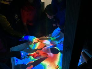 Why do you want to be a GKiS Brand Ambassador?
  What are you going to do as an ambassador for GKiS? Help promote the GKiS brand, educate and mentor as many kids as possible through school career fairs, class presentations. And most of all bring awareness to the profession!
 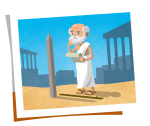 Eratosthenes
 North Atlantic Ocean 1985:
  Mount Everest 1999:
 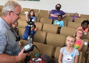 What are you going to be doing as an ambassador for GKiS?
 University: “If the university lifestyle appeals to you and you want to study a subject leading to a fast-paced, high-tech career, then a surveying-related degree could be ideal for you.
 Australian TAFE Qualification: “Work with civil engineers, builders, project managers and architects in the design and construction of major projects such as commercial buildings, bridges, roads, dams, tunnels and railways. Civil Construction and Surveying courses offer students a chance to gain hands-on experience and apply their expertise in the construction industry.
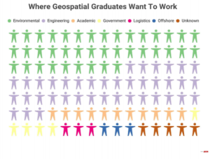
 Let us introduce you to our latest Brand Ambassador; Assumpta Jebichii, a final year student pursuing Geospatial Information Science at Maseno University, Kenya. Assumpta is dedicated, detail oriented and an approachable expert of GIS, remote sensing and survey, who attributes success to outmost discipline and determination. She has excelled in areas such as Geospatial software management (ArcGIS and AutoCAD civil 3D), data collection and research.