Character Spotlight ‘Pix4D’

Hi, I’m Pixie! Pix4D’s official mascot…

1.   Company Name

Pix4D

2.   Location 

Our headquarters are in Lausanne, Switzerland, a beautiful city on the shores of Lake Geneva. But we also have offices in places like Denver, Berlin, Madrid, Tokyo, and Romania. More importantly, our users are all over the world, bringing Pix4D’s mapping tools to over 170 countries. We’re everywhere you are!

3.   Why is it important for your company to help Get Kids into Survey? 

At Pix4D, our mission is to help build a better world, and we believe that starts with curious minds.  Surveying is about using technology to solve problems. With our tools, you can create maps to check on the health of forests, help map neighborhoods to create greener, safer spaces, or help farmers grow healthy food for us all. 

When you can see everything—from a tiny detail on the ground to a whole city from above—you can build safer roads or protect our planet’s special places.  

All of these jobs are about using technology to see the world in a new way and make a positive difference. We need future explorers and problem-solvers, and we know that kids are the best at that! 

4.   What do you do? 

We make software that helps people turn their pictures into maps. You take photos of a place with a drone or a smartphone, and our software uses a technique called photogrammetry to turn them into a digital copy of the real world.

We help all kinds of people—from surveyors and engineers, to farmers, or policemen. Our tools let them create detailed 2D maps and 3D models that make their jobs easier, safer, and faster. 

5.   How long have you been in the survey industry? 

Pix4D has been in the survey industry since 2011. We started as a group of university researchers at the EPFL in Switzerland, one of the top technical universities in the world! Back then, surveyors weren’t commonly using photogrammetry because it was too complicated or too costly. As pioneers in the field, we saw the potential of combining drones and photogrammetry to make it more accessible. 

For over a decade now, we’ve been helping professionals around the world turn their pictures into maps and models.

6.   How did you end up getting into the geospatial industry? 

I was created by some very clever people at Pix4D who were trying to solve a big problem: making the science of mapping easy for everyone. They wanted a friendly face to show that this technology wasn’t scary or hard to use. So they made me!

My curiosity for exploring is what got me into the geospatial industry, and I’m happy to be a part of it!

7.   State a funny fact about you…

I tried to solve a mystery I saw behind a window, but all I found was a funny-looking alien! It made for a very interesting map…

8.   Favourite Survey technique and why?

My favorite is photogrammetry! It’s like a big puzzle. You take lots of pictures of a place from all different angles with a drone or a smartphone, and then our software stitches them all together to make a digital replica of reality. This is what makes all the magic happen here at Pix4D!

9.  Your website

10.  How did you choose the character, and what does he/she/it represent? Mean to you? What’s his/her name?

My name is Pixie! I was created to be the friendly and curious face of Pix4D who represents our values.

My curiosity for exploring and discovering new things is our secret to innovation! As your “Just Ask Pixie” helper, my job is to give you good answers and a hand when you need it, and that’s how we build trust. 

And because my maps are made so quickly, it means you have more time to get out and play! Lastly, the little checkerboard on my head is a Ground Control Point, which is our way of making sure every map is perfectly accurate. 

Ambassador Spotlight ‘Margot Phaneuf’

Welcoming latest Brand Ambassador Margot Phaneuf from North Carolina, USA:


What are your plans as a Brand Ambassador? We plan to educate high school and college students about surveying.
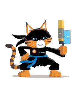
How did you get into the geospatial industry? I joined the company as their marketing coordinator this summer.

Tell us a bit about what you do? We provide surveying services, engineering services, SUE services, and UAV/drone services.

Character Spotlight ‘Topcon’

Introducing our longstanding sponsor Topcon!

“Hi, I’m Yumi, the Wild Cat Ninja from Topcon. I’m very excited to Get Kids into Survey and Civil Engineering…”

Company Name: Topcon Positioning Systems

Location: We are a global company with origins in Japan. Our positioning headquarters are in Livermore, California, which is located just east of the San Francisco Bay.

Why is it important for your company to help Get Kids into Survey?  We’re excited to help Get Kids into Survey. Surveying is like a fun adventure that includes cool science, tech, engineering, and math. Learning about it helps you understand how things are arranged in space, includes awesome technology, and gets you ready for jobs and important skills in the future. It’s like a big, fun learning journey for all the kids involved! 

What do you do? Our team, called Topcon Positioning Systems, makes really cool technology and tools that support people who build things and grow food. We want to help the world by making sure the surveyors, builders, and farmers have the best tools to do their jobs. With our tools, they can do their jobs easier and faster. 

Using our tools, a surveyor can stand in a field and figure out all the details about the land. They measure the length, width, and even the slopes of the land. It’s like making a giant blueprint that shows exactly how the land looks. They help other people know exactly where things should go, like where to build houses, roads, or even where to plant crops. Surveying is like creating a special map that guides everyone on how to use the land in the best way possible!

We also have products that use the information the surveyors gather to automatically control construction and agriculture machinery like bulldozers, excavators, and tractors. This helps those machines perform their tasks so precisely they can get to within a millimeter of their plans.

How long have you been in the survey industry? Our company, Topcon, has been around for over 90 years! We started in Japan in 1932, making surveying and optical equipment, including binoculars and cameras. As we grew, we opened offices around the world and focused more on the surveying equipment and eye exam equipment on the optical side. Starting around 1990, we expanded the surveying side of our business to include technology for construction and agriculture.

How did you end up getting into the geospatial industry? I got interested in protecting my kind because we were in danger. The place where we live was getting ruined, and it was putting us at risk of disappearing. I want to help make the world a better place for everybody, including wild cats. 

Land surveyors play an important role in supporting the environment by providing correct information about the land and everything on it. By knowing all the details about the land and its features, like where the hills are or where the rivers flow, land surveyors help others make smart choices to keep our planet healthy.

Surveying uses positioning, and cats are born with a keen sense of position. Like how we consistently land on our feet, we always like to be aware of our exact location at all times. So, being able to work in the geospatial industry was a purrrfect fit for me.

State a funny fact about you… I’m named after a famous ninja who possessed amazing archery skills. My name means “bow” as in bow and arrow. Ninjas are known to be most efficient in doing their work.

Even though I don’t shoot arrows or sneak around like a ninja, I like to think I’ve got my own set of skills. Cats are known for being pretty nimble and quick, just like ninjas! I bring a bit of those ninja-like talents into my daily adventures. After all, a cat named after a ninja has to live up to a little bit of that legendary reputation, right?

Favourite piece of kit and why?I like anything that uses GNSS since I always like to know where I am. GNSS means Global Navigation Satellite Systems, and it uses signals from satellites in space to determine your location on Earth accurately. It’s very similar to GPS (Global Positioning System), which you might know from your family cars or cell phones. GPS uses a group of satellites to tell you exactly where you are. GNSS uses GPS along with an even bigger group. It’s like a family of different satellite systems from around the world, not just the GPS one. There are others, like GLONASS from Russia, Galileo from Europe, and BeiDou from China. They all work together to help you know where you are, no matter where you are on Earth. And since GNSS uses even more than just satellites, it’s more precise and reliable.

Whether they’re measuring land, building complex structures, or growing crops, our customers rely on our tools that use GNSS to work faster and get things done really well! Our latest tool with GNSS, the CR-H1, can even fit on your cell phone, so it really is mobile mapping in your paw!

Favourite Survey technique and why? Laser scanning. It’s like a super-fast camera that can capture thousands of points every second. This is really helpful because it means the scanner can collect lots of information quickly, even if it needs to scan a big area. So, if you want to gather data about a large place, like a park, a tunnel under the ground, or a building, the laser scanner can do it quickly and easily. And, as you might know, cats LOVE lasers.


Remember to check out our Homework Project, The Road To Success! Available to print out for free on GKiS Resources Page.

Character Spotlight ‘MnDOT’

Welcoming our latest Brand Sponsor the Minnesota Department of Transportation! Let learn some more about them:

1. Company Name – Minnesota Department of Transportation (MnDOT)
2. Location – Saint Paul, Minnesota, USA
3. Why is it important for your company to help Get Kids into Survey?
At MnDOT, we know that inspiring the next generation of geospatial professionals is vital for the future of infrastructure, transportation, and mapping. Many young people don’t know that careers in surveying and photogrammetry even exist, so we want to spark curiosity early — showing kids that they can combine technology, science, and creativity to shape the world around them.
4. What do you do?
I’m a Photogrammetric Technician. I use aerial imagery, LiDAR, and advanced mapping tools to create accurate 3D models and maps for Minnesota’s transportation projects.
5. How long have you been in the survey industry?
Since 2022.
6. How did you end up getting into the geospatial industry?
In high school, I joined MnDOT’s Phoenix Internship Program, which introduced me to the fascinating world of transportation research and mapping. That early exposure to STEM opportunities led me to pursue photogrammetry as a career after college.
7. State a funny fact about you…
I have an identical twin sister who also works in the geospatial field! She’s a GIS Coordinator, and we currently work together at the same agency — the Minnesota Department of Transportation. Yes, it sometimes confuses our coworkers!
8. Favourite piece of kit and why?
Our 3D stereo monitors — they bring aerial imagery to life, letting me see depth and detail in a way that feels like stepping right into the landscape.
9. Favourite Survey technique and why?
Aerial photogrammetry — because it allows us to capture large areas quickly and turn images into precise 3D data. It’s like puzzle-solving from the sky!

Character Spotlight ‘QTS Group’

GKiS are thrilled to welcome our latest brand sponsor, QTS Group! Let’s learn some more about them:

1. Company Name – QTS Group

2. Location – All across the UK

3. Why is it important for your company to help Get Kids into Survey? Overall, social value is essential, but giving kid the insight in surveying will essentially benefit surveying for years to come.

4. What do you do? We work to help look after and maintain the rail infrastructure in the UK … and that includes utilising technology such as total stations, GPS, laser scanners and drones. As a survey department, we use drones and cameras to produce LiDAR and photogrammetry data.

5. How long have you been in the survey industry? 22 Years and counting!

6. How did you end up getting into the geospatial industry? In my 20’s I decided a career change was needed a friend asked if I wanted to try out as a survey assistant…

7. State a funny fact about you… I’ve been out in the field so long, I wave at the total station as if it were a person 😅

8. Favourite piece of kit and why? I would say all the new drone technology. It has changed the way we survey and saves a great deal of time in the field.

9. Favourite Survey technique and why? Photogrammetry is my favourite technique, it’s versatile and doesn’t necessarily require fancy hi tech equipment. You can even produce detailed 3D models using a phone!

10. Your website

11.  How did you choose the character and what does he/she/it represent? Mean to you? What’s his/her name? Wee PB (is a pint-sized powerhouse of surveying knowledge), based on myself (Paul Brazill) and we think it is a great way to connect with the kids when we do events and presentations.

Ambassador Spotlight ‘James Batdorf’

Welcoming our newest Brand Ambassador James Batdorf from Lehigh Valley, Pennsylvania, USA:

How did you get into surveying? Started as a drafter and went out to help on the survey crew one day and basically never looked back.

What are your plans as a Brand Ambassador? Try to recruit kids in our local schools to get into surveying and mapping.

Tell us a bit about what you do? Manage the survey crews at Newton Engineering Group Pc in Allentown pa

Anything else that you’d like to add? I’m on the board of directors for the Lehigh Valley chapter of the Pennsylvania Society of Land Surveyors.

Ambassador Spotlight ‘Rebekah Keller’

Welcoming Rebekah Keller as part of the team from Racey Engineering based in Luray, Virginia, USA;

How did you get into surveying? We started as a septic Engineering company and have grown into larger/ commercial Engineering and have also added surveying to our services about 20 years ago. Now we survey all over Virginia.

What are your plans as a Brand Ambassador?  We plan to get into middle and high schools to talk to kids about the profession. We also hope to bring in scouts for a job shadowing experience. We also currently do internships and go to many local job/career fairs.

Tell us a bit about what you do? We are an Engineering and Surveying Company. We do stakeout, boundary, topo, construction, and drone-style surveying.

Anything else that you’d like to add? We were voted Best Companies to work for overall and Best Companies to work for in the Engineering Industry. We were also named one of Virginia’s TOP Employers for Interns.

Ambassador Spotlight ‘Ivan Arifeto’

Introducing Ivan Artifeto from Harare, Zimbabwe, Africa:

How did you get into surveying? AFTER ENROLLING IN 2019 FOR AN UNDERGRADUATE GOEMATICS DEGREE AT THE UNIVERSITY OF ZIMBABWE.

What are your plans as a Brand Ambassador? TO GET TO EDUCATE WHAT A SURVEYOR DO AND HELP KIDS WITH CAREER GUIDANCE IF THEY ARE TO CHOOSE THIS PROFESSION AS A CAREER.

Tell us a bit about what you do? I AM A GRADUATE TRAINEE LAND SURVEYOR AT MASIMBA HOLDINGS LIMITED.