
 Project: Solomon Islands
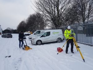
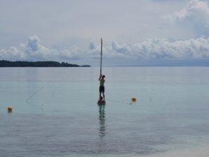 survey, as you can see sometimes it takes a team to setup the tide pole (TP image). It was a nice change from our usual survey areas that we didn’t see the red eyes of crocodiles at night as we took our measurements by torchlight. At one stage during the survey our ship had to go and have engineering repairs, so the two survey launches and a small runabout were left on a deserted island for three days. We had food from the ship, but didn’t end up eating much of it as we caught fresh fish and shellfish throughout the day. We worked hard, but relaxed around the fire at night under the stars and miles from anywhere, and we helped make the area safer for the next generation”.
 One of my favourite multi-disciplinary moments was working for National Parks and Wildlife Services. We were working for them to do cliff line stability assessments to help realign a hiking track after the 2019/2020 bushfires. I got to visit parts of the park most other people aren’t allowed to see and
 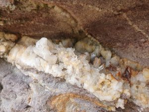 combine my two passions, geology and mapping. Workwise, I flew drones along cliff lines to take aerial photos we used to create 3D models and then got to sit down and sketch the cliffs and the geological features. Working on cliff lines with sea caves all along the coast, whale watching, 4WDing and stumbling into surreal environments was something special and I’ll never forget. Finding a cliff full of quartz crystals was the icing of the cake!
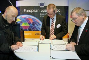 By the initiative of CLGE and NSPS with the endorsement of FIG the Première celebration of

 What are you going to do as an ambassador for GKiS? Talk to kids, presentations, careers events, publicity opportunities.
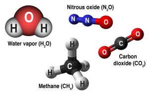
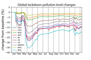 It is interesting to see how the effects of ‘lockdown’ affected emission rates. Shown here in this graph:
 Where did you study?
 If you are interested about being an Ambassador for GKiS please click
 Please fill out the form below to access our Translation Options Hotsheet:
With the average age of a surveyor rising, with more retiring than being recruited each year… there is definitely call for change! We began our campaign last month to collect everyone’s stories and create some snippets of information to share with the community. This is so they can see how awesome a career in geospatial really is!
Our aim: to showcase how diverse the industry is, what adventures it can take you on and the opportunities it could bring.
Please visit our Facebook and Instagram pages for more fun content. Plus longer videos are being added to our YouTube channel.
Enjoy some snippets of what some lovely surveyors get up to at work… there are some pretty cool experiences!
First up is Jamie Stevens from Nuplan Surveys Ltd…doing some Laser Scanning from St Saviour’s Point, Polruan, Cornwall.
“This was taken on a glorious day 17th Dec 2020, I have been a land surveyor for over 30 years and have had many such wonderful days (and numerous horrible ones too!)”.
‘oh how we all love to be beside the seaside’ as the saying goes! As a surveyor you could be spending days doing just that!
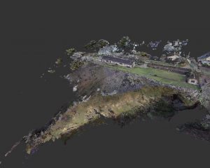 A bit more information about what Jamie was doing this day is attached- a “screenshot taken from our registered point cloud. It is proposed to demolish the small cottage on the cliff top and replace it with a modern multi-million pound residential house. We were set on St Saviours point (the cliff top in the video) for one of the many scans used to create this cloud as it offered a great view of the existing property and its surroundings. This completed scan data will be used by the architects to help inform their design and also to show any proposed redevelopment in context with its surroundings to the local planning authorities”.
Alex McKee, Graduate Surveyor, Academy Geomatics
“I was once tasked with creating a 3D model of an old bridge which was about 100m above the valley floor. The main part of the bridge was easy, however the client wanted the sides of the bridge too… so we turned our laser scanner sideways, pushed it as far over the edge as possible and weighed it down with a couple of weights! The scanner was about 2 meters away from the bridge, held up by a thin tripod. I was too nervous to let go for the first couple of scans, but the weighted system worked and thankfully it never fell over the edge. We managed to create a full 3D model of the bridge without dropping any of our equipment – a successful day in surveying!”
Carlos Betancourt- El Savador
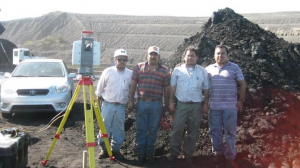 “I had been doing surveying on very diverse and odd places. One worth to mention was one time I was traveling in the middle of nowhere Mexico, willing to show a laser scanner to a coal mine company. That day basically what ever could go wrong was going wrong. All of a sudden I was just in the middle of a huge coal stockpiles field, and with that bad luck streak as you might expected, there was a power failure with the power source of the scanner, that setback seemed sealed the doomed destiny of the visit, when a guy of the coal company said, no problem I’ll bring a power cord, being half a mile from the closet power outlet, it was surreal to watch the guy pull the longest power cord extension I had ever seen, the scanner worked perfectly plug to the power supply, we even moved farther from where we were and that definitely saved the day!”
Benjamin Brewster- United Kingdom
“Years ago working on a job for the London 2012 Olympics at Eton Dorney, some colleagues and I were stopped walking up a fairly nondescript towpath on the Thames by a security guard and told we couldn’t carry on. We explained what we were doing and he agreed to let us walk through whatever was going on, as long as we didn’t stop and definitely didn’t take any pictures. Turns out we were walking through a shoot for a Take That music video. Not the most exciting story but Robbie Williams on a break was definitely a novel excuse for a gap in the data…”
Beau Winfrey- City Surveyor.
“I almost always enjoy working in the field, but my most memorable project was a volunteer project working with Rotary International, University of Oklahoma Centre for the Restoration of Ecosystems and Watersheds, and Engineers In Action. I was able to travel to Bolivia to perform the topographic survey for an environmental engineering project’s planning and design. The project is a passive treatment system to remove heavy metals from mine waste water outside of Potosi, Bolivia. I ended up working with local surveyors and using equipment that was set up in Spanish, not my first language. I mistakenly got all my backsights reversed / mirrored which was fun to correct in the office once back in the states. Good field notes and procedures for the win! Our goal was to map out two seasonal drainage channels from the high end of the valley where waste water pooled collecting toxic runoff from the surrounding abandoned mines and then drained into the lake and river below polluting the drinking and irrigation source for everyone in the area. The project started at approximately 4500 meters elevation and dropped 1000 meters along the 2 km route. Our survey was used to design the project and to communicate the plan. It was great to experience the culture and different work processes and meet some of the true characters involved in the project”.