

 By the initiative of CLGE and NSPS with the endorsement of FIG the Première celebration of

 What are you going to do as an ambassador for GKiS? Talk to kids, presentations, careers events, publicity opportunities.
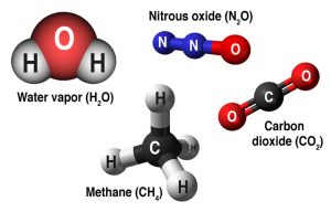
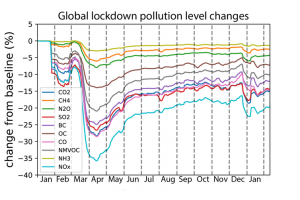 It is interesting to see how the effects of ‘lockdown’ affected emission rates. Shown here in this graph:
 Where did you study?
 If you are interested about being an Ambassador for GKiS please click

Please fill out the form below to download our Monopoly Sponsor Info Sheet Download:
With the average age of a surveyor rising, with more retiring than being recruited each year… there is definitely call for change! We began our campaign last month to collect everyone’s stories and create some snippets of information to share with the community. This is so they can see how awesome a career in geospatial really is!
Our aim: to showcase how diverse the industry is, what adventures it can take you on and the opportunities it could bring.
Please visit our Facebook and Instagram pages for more fun content. Plus longer videos are being added to our YouTube channel.
Wild days at work… Let’s hear some stories from some surveyors from around the world!
Nick Townley– Hydrographic Surveyor
 Project: Solomon Islands
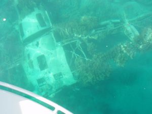
“Survey can take you to many exciting places and one of my favorite surveys was in the Solomon Islands where we were surveying WWII mine fields, this was to allow mine hunters to go in and make any explosives we found safe. The water was crystal clear and we could look over the back of the vessels and take pictures of the wrecks below (WWII_Airplane image). Due to the distance from a sounding datum we had to have a tide camp on the beach to connect the height of tide measured on a pole to the new geodetic GPS survey marks we installed. This involved setting up a tide pole and doing a shore 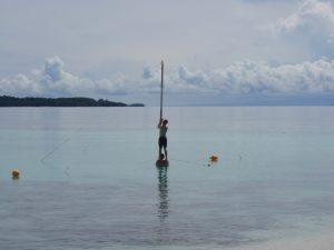 survey, as you can see sometimes it takes a team to setup the tide pole (TP image). It was a nice change from our usual survey areas that we didn’t see the red eyes of crocodiles at night as we took our measurements by torchlight. At one stage during the survey our ship had to go and have engineering repairs, so the two survey launches and a small runabout were left on a deserted island for three days. We had food from the ship, but didn’t end up eating much of it as we caught fresh fish and shellfish throughout the day. We worked hard, but relaxed around the fire at night under the stars and miles from anywhere, and we helped make the area safer for the next generation”.
Brian Harding (Survey Manager)
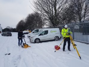
“After nearly 20years in the field, although I more often call my desk chair my home these days, I have a few memorable projects. The one that sticks out as the most rewarding was setting up a static GNSS control network in outback Australia for upgrade of Queensland road scheme. Highlights would be seeing the wildlife more kangaroos than you can count, emus running through farmland, snakes (generally dead in the road) but also the terrain out near the desert and the tiny communities scattered out in the middle of nowhere. Looking at the milky way at night was also pretty epic, growing up in London it’s not something you get to see.
A near second favourite project would be setting up the control network for the 2.2km undersea pipe drilling rig. And seeing turtles and Dugongs surface while taking readings on the bay of Curtis island. Queensland. Also some interesting projects in the uk like 3D scanning the highest tower in England, and a site visit for 3D scanning cave systems for erosion assessment and finding a baby seal cub not 6ft from our team. A great career to see places most don’t get to see”.
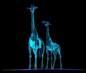
Alex Perepechay – Survey Consultant & 3D Laser Scanning.
“Not a story, but just a nice image from one of the recent projects”.
Sonwabile Duda– South Africa
“My story happened in 2004 as a student Surveyors doing in-service training my two colleagues who were more experienced were busy trying to find a mechanic in town of Ceres they left me in the field alone surveying and it got dark before they returned by to me after 9pm at night inside a nature reserve. I packed the Trimble GPS into its cases base and rover and carry the tripod up the mountain to find a safe place to hide under big cliff. I stayed there alone with wild animals coming at night to hunt, I was scared but could do nothing except keeping quite. I saw a light approaching it was them. It was funny they could not find me next to the road they were screaming my name in the dark whilst I was high up under solid rock, they got scared as to what if something terrible happened, how would they tell my family they lost me in the mountains alone. I emerged out of a cave/cliff. They could hear my reply but could not locate me. It was dark coming down the mountain with GPS set and trip, it was like a movie when we reunited in the dark. We got home in the early hours of the next day. The drive from the site back to office was more than 4 hours.”
Alex Carling– Engineering Geologist at Cardno
 One of my favourite multi-disciplinary moments was working for National Parks and Wildlife Services. We were working for them to do cliff line stability assessments to help realign a hiking track after the 2019/2020 bushfires. I got to visit parts of the park most other people aren’t allowed to see and
 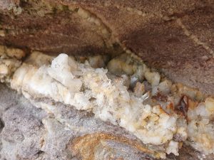 combine my two passions, geology and mapping. Workwise, I flew drones along cliff lines to take aerial photos we used to create 3D models and then got to sit down and sketch the cliffs and the geological features. Working on cliff lines with sea caves all along the coast, whale watching, 4WDing and stumbling into surreal environments was something special and I’ll never forget. Finding a cliff full of quartz crystals was the icing of the cake!
Ts. Gs. Muhamad Shafri– Geospatial & Survey Specialist Officer.
Project: Cadastral Survey
Location: Kuala Lumpur, Malaysia
VIDEO LINK: https://youtu.be/Y2q5f2gVz-w
“I am a Survey Technician registered under Act 2015 (Act 786) Malaysia Board Of Technologist
This is a recording by myself using an old model mobile phone, the camera is only 3gp. This was in 2008 where I was entrusted to do survey work for the Oil Palm Border Fraction. And currently, advanced devices such as GPS and others are still not used in Malaysia. You can see the real life of a Surveyor during the previous years of long time ago.
Last word from me, Surveying career does not require high academics”. Just keep interested and passionate!