
 Where did you study?
 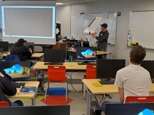 Why do you want to be a GKiS Brand Ambassador?
  1- The GeoSquad help to teach kids (and adults) about the types of jobs surveyors do. Help your kids understand what you do for a living!
 Your
Your  Where did you study?
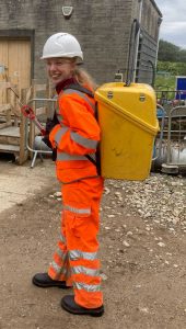 Follow along as team member
 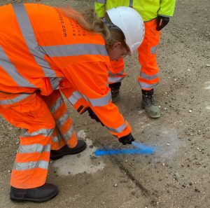 Firstly, we hammered some markers in the ground and spray painted around them with their numbers. Around the boundary of the site there were 8 points, ensuring that we could see a clear path back and forth to the previous point (so that the equipment could connect, ‘see’ each other as I like to think).
 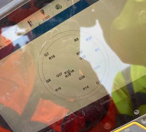 The two first points need to be a ‘known’ location so this requires the GNSS system. The GPS communicates with the satellites (see picture) to get the exact location of our point. With this it calculates the distance and angles between the two known, in order for us to apply this to all the other points on site.
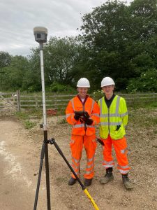 There is a reason that the GPS isn’t used to calculate all the points, but instead the total station and laser scanner come out. This has 3-4mm error range whereas the GPS has plus or minus 30mm accuracy! So better results with total station, which is very useful for everyone on site.
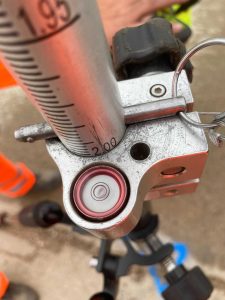 For each point onwards the total station needed to be levelled, this was done firstly using the eye tool. What was cool about the SX10 was there was a camera on the bottom which allowed you to see when the scanner lined up exactly over the point in the ground. This was a little challenging as you then have to level the top part too using 3 twisty rounds (the sighting and the trunnion). Once nearly perfect we measure the height of the scanner from the ground and walk away to the next point.
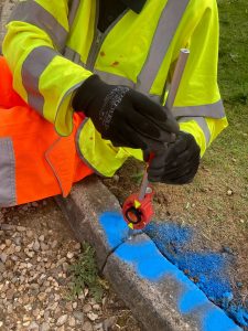 At the following point we align the SX10 to clock onto the prism (picture) at a height of 0.100m. Here the SX10 takes two measurements, turning 180 degrees for the second to reduce error. This method is called traversing (going back and forth taking measurements).
Please fill out the form below to download our Monopoly Sponsor Info Sheet Download:
2021 started off with a bang for the geospatial industry when the GeoSquad Comic Book was released back in May. Two whole years in the making, this really was a very exciting time and we finally saw the results of our efforts both online and in our hands.
Our team has seen first hand the changes in the industry over the last 20+ years, with an aging demographic, less recruits, and university courses struggling to attract applicants. Something had to be done about it … kickstarting the #GetKidsintoSurvey movement. At first there were a couple of posters which promoted the industry in a fun way, followed by quiz questions and colouring in sheets. But we needed something MORE, something bigger, something better!
A comic is something that can be put into libraries, schools, kids clubs, waiting rooms… the list could go on! Our aim: to give exposure to the industry by getting as many eyes on our geospatial resources as possible.
So, let us answer a few overriding questions that you may have about the Comic Book:
Why is there a high shipping cost? Our Comic has been designed and produced in the UK (where Elaine Ball Ltd are based). We wanted to keep it British and ensure the product can be quality checked easily by us, they are printed and shipped by our fabulous printers here in Yorkshire, UK.
Our shipping cost is correct for the size/weight of the comic book, as per Royal Mail. We put a small mark up for admin costs and packaging. Currently, the exchange rate is higher due to covid/political reasons, to certain countries such as Australia which is out of our control.
*We are happy for you to print in your country for bulk orders. The downside of this is that the quality check will still need to occur, making the process quite long. If this is something you’d like to do we are happy to oblige.
Who is the GeoSquad Comic Book aimed at? All of our resources are aimed at 8-12 year olds, although some younger children have read it with the help of their parents. Adults are known to enjoy it too so it has a very broad appeal!
What went into making the Comic Book? As previously mentioned, this venture began over two years ago with a basic idea. This was transformed into a story chapter by chapter, by our fabulous teacher and writer Mat Sulivan. Not only did the story need to be thought out from scratch, so did all of the characters, followed by each scene in every comic strip. Once the basics were sketched out, Marek, our fabulous cartoonist, transformed it into what you see as the finished comic strip.
But that isn’t all… The team worked so hard to get the first couple of chapters sponsored by different geospatial companies which were kindly published in POB and CES magazines. Building the brand up and gaining more exposure to kids via their parents. Once the final ten sponsors had been sourced for the book we were nearly ready for lift off. Countless hours have been spent by multiple team members on this project. This process took over 2 years, and cost £29,000, most of this was covered by our fabulous sponsors.
How much is the Comic Book? A hard copy printed comic book is £10.99 and is only available in GBP due to the ever fluctuating currency rates. We also have an e-book which is slightly cheaper at £6.99, which wouldn’t include postage charges.
Is Get Kids into Survey a Charity? No we are not a charity. Unlike other organisations we do not receive any external funding to produce these resources, so rely purely on the industries good will through sponsorship. We do however have an Education Fund which can be contributed to in order to help us produce and distribute these resources to those who cannot afford it.