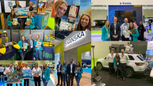
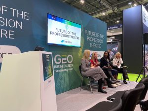
What an incredible week we had at GeoBusiness 2021… this year’s return after covid saw a change in venue from the Design Centre to the rather large ExCel Arena in London!
Team members Erin and Elly manned the stand for the duration of the show. Whilst our founder Elaine Ball was seen chatting away on two panel discussions about diversity and the future of the profession. She also took part in the VII CLGE Conference of the European Surveyor: Women in Surveying [online] via zoom! These are such important topics that are sure to be some of the industries focusses next year… ensuring we progress in the best possible way forwards.
We spoke to so many keen and willing people, there are so many who want to know how they can get involved. Everyone who left details with us should have had an email with more information explained on there. However, if not then please feel free to reach out to Erin on erin@getkidsintosurvey.com. For more information on becoming a Brand Ambassador please see our most recent blog here.
Whilst at the show we had the pleasure of going round some of the other attendees who are our sponsors… we met Skanska, Leica Geosystems, Trimble, Riegl, TopoDOT and Seafloor Systems.
Plus we were invited to attend the SCCS London Survey Awards night at the incredible St. Pancras Renaissance Hotel. We had a great time so thank you very much for your hospitality that night.
Our main aim of the event was to get the final sponsorship places filled for our last ever geospatial themed posters. The two topics are Digital Construction and A world Without Surveyors. We have managed to fill most of the sponsorship places but a couple do still remain so get in touch quick if your company would like to be up amongst some of the top names in the industry!! Our form can be filled in on this page, then we can send out the contract and invoice to solidify your purchase.
See you all again in May 2022 for round two of Geo Business. Happy New Year to all 🙂
Character Spotlight ‘GeoBiro’
Let’s hear it for ‘GB’ the amazing character by GeoBiro!
Company Name – Geobiro Ltd
Location – Bosnia and Herzegovina, Europe
Why did you get involved in Get Kids into Survey?Educating children about surveying is very important for the survival of our profession. There is very little material for children in this industry. We want to be part of a team that will bring surveying closer to the younger population!
What do you do? We are mainly a surveying company. Our company provides various services and geospatial solutions for businesses worldwide. We offer services in the field of laser scanning (Point cloud registration, Scan to BIM, Scan to CAD) to companies around the world.
How long have you been in the Survey Industry? This year our company celebrates 30 years of existence.
How did you get into the Industry?Geobiro is a family business, now in its second generation. For all of this time we have been trying to be market leaders and follow trends.
Funny Fact about you – Geobiro has over 50 employees but one interesting fact: No employee is older than 40!
Favourite piece of kit and why? Laser scanner industry – They all have their advantages, I would not favor one 🙂
Favourite Survey technique and why? Laser scanning – With one device, we collect all the necessary data without the need for additional field trips. Virtual reality through laser scanning is becoming commonplace.
How did you choose the character and what does he/she/it represent? Mean to you? What’s his/her name? Our character is a kind of robot that represents processes in our company. We have 3 departments in our company (3 hands), laser scanning, point cloud registration, 2D/3D deliveries. At the same time, it scans, processes point clouds and creates BIM ready models. That is the motto of our company – To take laser scanning data from our surveying clients and deliver excellence. We can call him GB (:
ROI, time and cost aren’t a good fit for us!
ROI, time and cost aren’t a good fit for us! Consider these 3 things before saying no:
1- Be seen multiple times
When you invest in a resource, it’s impossible to imagine where that might be seen- offices, schools and libraries. So much exposure of your logo and branding. These then have further linking resources such as colouring in sheets, Q&A’s and Homework projects which all link back to one another. These stimulate deeper understanding of the geospatial industry and help kids learn more.
Not forgetting the large online presence GKiS have with an average of 2:21 time on page! We have 20 collectable posters, so there’s limited opportunities to get involved remaining for the linking Homework Projects.
2- Be in it for the LONG TERM, build your brand
Our target audience for our resources are 8-12 years old. They won’t begin careers until around 20 years old… where they choose university degrees or apprenticeship routes. That means we won’t start seeing the results of our resources for 10 years after they’ve used them.
We were founded in 2017 so have only been around for 4 years. At this point we don’t know what effect we have had, and it will be very difficult to track. We push as many resources out as possible and ensure as many children get to know what the geospatial industry is.
Our aim: to get more people into the geospatial industry. Let’s try to stop this skills shortage for an amazing career.
3- Exposure is high… leading to possible sales
As a brand we have many industry connections, GKiS are present at a range of different shows and conferences. When people see us, they see you too! Displayed all over our website, materials and stands are all our sponsors logos/characters. This could be your way in to gain so much exposure off the back of us (and we hope we get a similar return). Backlinks are great for google search!
Are you tracking your exposure and conversions to sales? With the addition of a character spotlight blog (see example here) on our website, plus the other links, there is an opportunity to track that conversion… If any of our sponsors have done this, please let us know. Our blogs have an average 600 views per month, with an average page time of 1 min 49 seconds.
For help on how to track this information and create campaigns please speak to our founder Elaine Ball.
What do our supporters and sponsors do on their websites?
Beasurveyor.com are an amazing example, they get quite a lot of traffic through their website which leads people to our resources! Run by NSPS they are one of our distributors, we have a lot to thank them for, helping us promote the industry to the next generation.
Or it could be as simple as linking our logo to your website to gain traction that way. As seen in this example by minimapmakers:
We hope this blog has given you something to think about? We would love to hear from you if you’d like to take one of our final remaining places on either Digital Construction or A World Without Surveyors. Have a look at our sponsorship page now. Or email hello@getkidsintosurvey.com
Ambassador Spotlight ‘Karen Joyce’
Welcome to our Brand Ambassador Karen Joyce from Australia! Karen runs the very cool ‘She Maps’ so make sure you take a look at that too.
How long have you been in the industry? I have been in the spatial industry for over 20 years since completing my PhD at the University of Queensland.
Are you part of any associations or organisations you would like us to mention? We are proud to be working closely with The Surveyors’ Trust in Queensland, Australia to support schools, and raise awareness of the industry opportunities.
Why do you want to be a GKiS Brand Ambassador? The GKIS brand aligns so well with our values at She Maps and the engagement we are wanting to achieve with school students. Power in numbers!
Why is it important for kids to know about surveying and the wider geospatial industry? Most of us have heard about the importance of STEM (science, technology, engineering, and maths) education and STEM in the workforce. But did you know that STEM is also somewhat of a clique, and one in which geography is not invited? With government education investment priorities firmly nested in STEM, we need to ensure that geography and geospatial skills aren’t left by the wayside. This is despite the prevalence of, and reliance upon geospatial technology in everyday life, with very few people outside of our discipline ‘bubble’ would even be aware of the term ‘geospatial’. We want to ensure that our workforce of 2030 has the skills, passion, and diversity needed to drive geospatial applications towards a stronger economy.
What are you going to do as an ambassador for GKiS? We promote the posters and resources through our business, She Maps, and also the geospatial and surveying opportunities more broadly.
What are your hobbies? I enjoy road cycling, spending time at the gym, and reading.
If you/your company had a GKiS character, what would it be? We already have one, Dronie!
What poster or resource would you like to see next from GKiS? I’d love to see one on coastal ecosystems and the great work surveyors and geospatial professionals are doing to protect ecosystems.
Anything else you want to add that you think our audience (surveyors, teachers, parents) would be interested in? You can find out more about the work we are doing atwww.shemaps.com
Character Spotlight ‘Fugro’
Welcome on board our new sponsors, Fugro! Let’s dive in to learn more about their character:
Company Name: Fugro.
Location: Leidschendam, Netherlands.
Why did you get involved in Get Kids into Survey? Educating students about new ways to explore the world is the best way to get them interested in the survey sciences.
What do you do? We use advanced technology to explore the earth’s surface and subsurface, creating maps about different parts of the world and explaining its composition (what it’s made of). We do this on land and underwater. The information we gather helps our clients make good decisions about how to use natural resources, like water, minerals, and food. It also helps them safely build and maintain infrastructure, like roads and bridges, ports and harbors, and pipelines and cables.
How long have you been in the Survey Industry? Fugro was founded in 1962, focusing on soil mechanics and foundation design. We added survey solutions to our capabilities in 1991.
How did you get into the Industry? We began by integrating positioning technology into our work, which helped us increase the accuracy of our existing services. Soon we added many more survey capabilities that allowed us to provide more services to our clients, including mapping large areas of land and sea. Today we are a recognized leader in the field, providing many different types of survey offerings to our clients to match their information needs.
Funny Fact about you: Fugro is a Dutch abbreviation for fundamental ground mechanics
Favourite piece of kit and why? We have so many, it’s hard to choose! But we’ll highlight our RAMMS system because it can be used to quickly map coastal areas, which is of pressing importance right now given the impacts of climate change and sea-level rise. RAMMS stands for Rapid Airborne Multibeam Mapping System. It is operated from a small airplane or drone and uses laser beams to create maps of the seafloor. Scientists use this information to understand and protect fish habitats, mariners use this information to plan safe transportation routes, and engineers use this information to understand potential hazards from hurricanes and other large storms.
Favourite Survey technique and why? We love all things remote and autonomous. We are using uncrewed platforms to acquire survey information from the air (like RAMMS) and from the sea. These advanced systems provide faster, safer, and more sustainable acquisition and delivery of survey data. It’s better for our employees; it’s better for our clients, and better for the environment!
How did you choose the character and what does he/she/it represent? Mean to you? What’s his/her name? Our character is a small fixed-wing aircraft flying our RAMMS system. The equipment we used to use to map coastal waters would have filled your bedroom from floor to ceiling, but with RAMMS we can fit all that technology into the size of a small suitcase. This small size is what leads to huge efficiency gains, both in terms of survey speed and reduced carbon emissions.
What are the requirements to be a surveyor in your area?Anyone can become a land surveyor over time but for all surveying disciplines you require a knowledge of STEM subjects and a good attention to detail. My company focuses on water-based projects so I have a greater understanding of water whether within rivers, lakes or the sea.
How did you get into surveying?I was in my early twenties having left school after my A-levels not knowing what I wanted to do. I worked in farming through my school years and enjoyed the outdoor life but always felt there was something out there better suited to my skills. It was my mum who saw an advert in the local paper for an assistant land surveyor and suggested I try for that. I was hooked and took to it like a duck to water. I joined an established company who put me through the Survey Association course at the Survey School in Worcester. This was a newly established 2-year block release course which I really enjoyed and provided the theory to back-up the practical site work I was completing every day in my day job.
How long have you been in the industry?It will be 20 years in July 2021.
Are you part of any associations or organisations you would like us to mention?I am an Associate member of the RICS and hope to be a member of the CICES by the end of the month.
I am Vice Chair of Governors at a local primary school where I also chair the performance and standards committee. I am passionate about the education of young children and want to help provide opportunities to all through knowledge and experience.
Why do you want to be a GKiS Brand Ambassador? I want young people and children to understand the opportunities involved with a career in surveying or a related field – the technology, the indoor/outdoor balance and the travel to name a few!
Why is it important for kids to know about surveying and the wider geospatial industry?Surveying and geospatial data plays such a huge part in our everyday lives, much of which we don’t even realise. From gaming through to sustainability of the planet’s resources, surveying is involved with so much analysis and decision making the world over.
What are you going to do as an ambassador for GKiS?Continue to share my knowledge of the geospatial industry and all things related.
What are your hobbies?Although rugby has been my main hobby for the majority of my life, I am now too old for all that rough and tumble and so instead I have taken up karate! Hope to gain my blackbelt before the end of 2021.
If you/your company had a GKiS character, what would it be?Something from a river or the ocean or maybe Captain Birdseye esque!
What poster or resource would you like to see next from GKiS?As part of the resources, we could offer some larger projects involving a feasibility study, then surveying, designing, and finally setting out the development. Maybe the local village needs a new skate park? The school utilise a BA to help with the process from feasibility through to setting out -just don’t build it!!
Top Benefits of Becoming a Sponsor
Unsure of the benefits of becoming a sponsor? Or are you questioning if it is worth it? Join this lovely bunch of sponsors in 2021 as we introduce new resources and exciting new projects, all requiring your help!
Top benefits of becoming a sponsor
1- Brand exposure in front of thousands of people!
Get Kids into Survey has support from all around the world, from our 3 amazing distributors in the UK, Australia and the US; To the over 50,000 survey loving people worldwide who have one of our physical posters! We also have an amazing network of Brand Ambassadors who take our resources and promote them/the industry in front of hundreds of school children. Every time someone sees your character they will notice your logo and be able to recognise that as they grow older. SO much exposure and fun to be had with team GKiS!
2- Become part of the GKiS family
Being a part of the GKiS family and networking within our community is a great way to get yourself known. We have so many connections which are continuously growing and all over the world too. Our Brand Ambassadors also help, getting involved by taking the resources you help to produce, to local schools, events and local organisations etc. In turn this has started to build our educational community, more so this year with the release of more lesson based plans and activities. Here’s hoping we can get back to the in person conferences later this year where we can all start interacting
3-Help provide FREE resources that kids will enjoy
One positive about our materials being free to access for kids, is that absolutely anyone can access them no matter what their financial situation. These resources are continually being expanded and recently lesson plans have been added when lockdown hit so that parents had something for their kids to do at home. These resources all link back to the posters that your sponsored character appears on. It is your sponsorship money that makes this happen!
4- Build momentum, start small with BIG consequences
There is a huge lack of career advice and awareness on Surveying, so help educate parents, children and the general joe blogs at a local level. If we don’t stand up and start to build momentum now, companies are going to be in bigger trouble long term with lack of surveyors (it is already happening). Businesses poaching staff members and further disruption all round. Not a nice situation to be in when you are trying to run a profitable business.
“In 2018, there were 55,000 chartered surveyors in the UK, either employed or self-employed. This number has fallen from 63,000 in 2011” Source/ Credit Macdonald and Company.
5-Marketing material with a cartoon character
Our very own cartoonist will create a character of your choice. Have a look at all of our character spotlights here (Latest Blogs – Get Kids Into Survey) for an insight into other companies ideas! We love those who really take on their character and write from their perspective. Something that can be incorporated into your own marketing material to capture people’s interest.
GKiS also shows your soft side and builds a unique picture about your business. Look at Trent Keenan at Diamondback Land Surveying, he is so passionate about getting kids into Survey, he has sponsored the local Nascar – this not only promotes the profession but raises his profile as a Surveyor in his area!
6-YOU are helping to save the industry and hiring crisis!
Let’s be honest, the surveying industry will slowly die out if younger people aren’t being recruited or interested in joining the industry. By being a sponsor you are directly helping with gaining exposure to what we do, so children understand and recognise this as a career option. The more we capture a child’s interest, the more likely they are to consider this in later life. Keeping surveying on the radar!! The baby boomer generation is retiring and with the average age of a surveyor globally at 55 this is very concerning. GKiS is a long term strategy which was started in November 2017! It is an industry that we cannot afford to lose.
Don’t Miss out! Be part of the movement to Get Kids into Survey!
We are focussing on Homework Projects as our current campaign. There will be a couple based on each of the collectable posters for Surveyors, parents and kids to have a go at. These dive deeper into the knowledge behind the things going on in the posters, so much more to learn. Moving forwards we are going to put a lot of emphasis on promoting our current sponsors, so it will have a double whammy; Get kids into Survey and promote your brand as one of the main companies that helped raise the profile and Get Kids into Survey!
Welcome to our Brand Ambassador Jocelyn Correa, from California USA!
Where did you study? I did not go to school for Land Surveying, I went to a local community college for Architecture and Sociology
What are the requirements to be a surveyor in your area? In California, it is either a combination of a degree related to land surveying, and/or experience under another Licensed Land surveyor, for a total of 6 years. For example, 4 year degree, plus 2 years experience… or 6 years of experience.
How did you get into surveying? I worked for a local Assessor’s office, originally getting the job just because I knew AutoCAD, but wound up learning the basics of Land Surveying concepts
If you are not a surveyor, what do you do?
How long have you been in the industry? I started as a cadastral mapper in 2004, so a bit over 16 years. I’ve been with a Land Survey/Engineering company for the past nearly 7 years.
Are you part of any associations or organisations you would like us to mention? CLSA (state member and Local chapter secretary), NSPS member, and past ASPRS member
Why do you want to be a GKiS Brand Ambassador? I want to have additional resources to reach out to schools in my area, and assist with promoting our AMAZING profession. I think partnering with GKiS will assist me connect with the kids better, and not have to generate interest-catching material myself
Why is it important for kids to know about surveying and the wider geospatial industry? Surveying is a VITAL profession for the future of the built environment, for future infrastructure and repairing or maintaining existing infrastructure.
What are you going to do as an ambassador for GKiS? As a brand ambassador, I’d like to begin presenting to more schools, and reaching a larger age group. Currently, I have only worked with students in a High School geometry class, and also worked with the DiscoverE Future Cities competition. I think it’s important to also expose younger kids to the Land Surveying profession
What are your hobbies? I love watching my kids participate in their activities: gymnastics, baseball, horseriding, and theatre. As weird as it sounds, I also love organizing, planning, and cleaning.
If you/your company had a GKiS character, what would it be? If my company had a character, I think we’d be a chameleon… we do SO many different services to make the built environment possible. If I was a character, I think I’d be a deer… a bit high-strung, but shy, intuitive, and very aware of my surroundings. If it was a survey specific character, I think I’d be a researcher… I LOVE researching old documents, maps, and the history involved in land surveying
What poster or resource would you like to see next from GKiS? I think stickers would be awesome!
We use cookies on our website to give you the most relevant experience by remembering your preferences and repeat visits. Read More.
This website uses cookies to improve your experience while you navigate through the website. Out of these, the cookies that are categorized as necessary are stored on your browser as they are essential for the working of basic functionalities of the website. We also use third-party cookies that help us analyze and understand how you use this website. These cookies will be stored in your browser only with your consent. You also have the option to opt-out of these cookies. But opting out of some of these cookies may affect your browsing experience.
Necessary cookies are absolutely essential for the website to function properly. This category only includes cookies that ensures basic functionalities and security features of the website. These cookies do not store any personal information.
Any cookies that may not be particularly necessary for the website to function and is used specifically to collect user personal data via analytics, ads, other embedded contents are termed as non-necessary cookies. It is mandatory to procure user consent prior to running these cookies on your website.
Monopoly Sponsor Info Sheet Download
Please fill out the form below to download our Monopoly Sponsor Info Sheet Download:
Autumn Poster Hotsheet Download
Please fill out the form below to access our Poster Hotsheet:
Summer Poster Hotsheet Download
Please fill out the form below to access our Poster Hotsheet:
Spring Poster Hotsheet Download
Please fill out the form below to access our Poster Hotsheet:
Poster Hotsheet Download
Please fill out the form below to access our Poster Hotsheet:
Re-Print Hotsheet Download
Please fill out the form below to access our Re-print Hotsheet:
Winter Poster Hotsheet Download
Please fill out the form below to access our Poster Hotsheet:
Homework Project Info Pack
Please fill out the form below to access our Homework Project Information Pack:


 How long have you been in the industry?
  Where did you study?
  Why do you want to be a GKiS Brand Ambassador?
 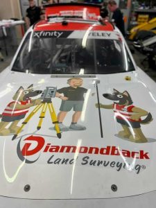 GKiS also shows your soft side and builds a unique picture about your business. Look at Trent Keenan at
 Where did you study? I did not go to school for Land Surveying, I went to a local community college for Architecture and Sociology
 Team members Erin and Elly manned the stand for the duration of the show. Whilst our founder Elaine Ball was seen chatting away on two panel discussions about diversity and the future of the profession. She also took part in the VII CLGE Conference of the European Surveyor: Women in Surveying [online] via zoom! These are such important topics that are sure to be some of the industries focusses next year… ensuring we progress in the best possible way forwards.