
 If you are not a surveyor, what do you do?
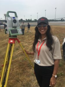
 Where did you study?
 Company Name – On The Mark Land Surveying LLC
Please fill out the form below to download our Monopoly Sponsor Info Sheet Download:
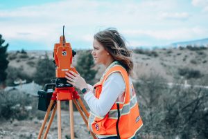
Welcome Tyler LaPointe from Tennessee, USA!
 Where did you study? East Tennessee State University. B.S. of Surveying and Mapping
What are the requirements to be a surveyor in your area?
62-18-109. Applications for registration:
(a)
(1) The board shall consider and evaluate a land surveyor applicant’s qualifications based upon:
(A) The applicant’s education, technical, and land surveying experience;
(B) Exhibits of land surveying projects with which the applicant has been associated;
(C) Recommendations and character references; and
(D) The payment by the applicant of a fee set by the board in accordance with § 62-18-125 with the approval of the commissioner of commerce and insurance.
(2) The board shall, in proper cases as authorized in this part, issue a certificate of registration as a land surveyor to any person who submits evidence satisfactory to the board that the person is fully qualified to practice land surveying.
(3) A land surveyor applicant’s qualifications may be reviewed at an interview if the board determines it necessary.
(4) Educational credit for institute courses, correspondence courses, or other courses shall be determined by the board.
(5) No person shall be eligible for registration who:
(A) Does not have a high school education diploma or a general equivalency diploma (GED®);
(B) Does not speak and write the English language; or
(C) Is not of good character and repute.
(b) The following shall be considered as the minimum evidence satisfactory to the board that the applicant meets the qualifications of a professional land surveyor:
(1) To be certified as a land surveyor intern (PLSIT), an applicant shall:
(A) Make a complete application to the board;
(B) Be of good character and reputation;
(C) Submit three (3) character references to the board, one (1) of whom is a professional land surveyor;
(D) Comply with the requirements of this part;
(E) Pass the Fundamentals of Land Surveying examination; and
(F) Satisfy one (1) of the following requirements related to education and experience:
(i) Obtain a baccalaureate degree from a surveying or surveying technology curriculum of four (4) or more years, approved by the board;
(ii) Obtain a baccalaureate degree from a science, engineering or technology curriculum of four (4) or more years related to the practice of land surveying, approved by the board, with a minimum of twenty-four (24) semester hours of board-approved coursework in the surveying sciences;
(iii) Obtain a baccalaureate degree from a nonsurveying related curriculum of four (4) or more years, approved by the board, plus an additional thirty-six (36) semester hours of board-approved coursework in the surveying sciences;
(iv) Obtain an associate degree in surveying technology or a related science, engineering or technical field, approved by the board, with a minimum of thirty (30) semester hours of board-approved coursework in the surveying sciences, a record of four (4) years of progressive practical experience, two (2) years of which shall have been under the direct supervision of a practicing professional land surveyor; or
(v) Obtain a high school education diploma or a general equivalency diploma (GED®) with a record satisfactory to the board of ten (10) years of progressive practical experience, six (6) years of which shall have been under the direct supervision of a practicing professional land surveyor;
(2) To be licensed as a professional land surveyor, an applicant shall:
(A) Make a complete application to the board;
(B) Be of good character and reputation;
(C) Submit five (5) character references to the board, three (3) of whom are professional land surveyors or individuals acceptable to the board and who have personal knowledge of the applicant’s land surveying experience;
(D) Comply with the requirements of this part; and
(E) Satisfy one (1) of the following requirements:
(i) Obtain a baccalaureate degree from a surveying or surveying technology curriculum of four (4) or more years, approved by the board, and a record satisfactory to the board of two (2) years of progressive practical experience after the applicant passes the Fundamentals of Land Surveying examination, one (1) year of which shall have been in responsible charge of duties performed under a practicing professional land surveyor. An applicant who passes the Principles and Practice of Land Surveying examination and the Tennessee State Jurisdictional examination shall be granted licensure as a professional land surveyor;
(ii) Obtain a baccalaureate degree from a science, engineering or technology curriculum of four (4) or more years related to the practice of land surveying, approved by the board, with a minimum of twenty-four (24) semester hours of board-approved coursework in the surveying sciences, and a record satisfactory to the board of two (2) years of progressive practical experience after the applicant passes the Fundamentals of Land Surveying examination, one (1) year of which shall have been in responsible charge of duties performed under a practicing professional land surveyor. An applicant who passes the Principles and Practice of Land Surveying examination and the Tennessee State Jurisdictional examination shall be granted licensure as a professional land surveyor;
(iii) Obtain a baccalaureate degree from a nonsurveying related curriculum of four (4) or more years, approved by the board, plus an additional thirty-six (36) semester hours of board-approved coursework in the surveying sciences, and a record satisfactory to the board of two (2) years of progressive practical experience after the applicant passes the Fundamentals of Land Surveying examination, one (1) year of which shall have been in responsible charge of duties under a practicing professional land surveyor. An applicant who passes the Principles and Practice of Land Surveying examination and the Tennessee State Jurisdictional examination shall be granted licensure as a professional land surveyor;
(iv) Obtain an associate degree in surveying technology or a related science, engineering or technical field approved by the board with a minimum of thirty (30) semester hours of board-approved coursework in the surveying sciences, and a record satisfactory to the board of four (4) years of progressive practical experience, three (3) years of which shall have been in responsible charge of duties performed under a practicing professional land surveyor if the applicant passes the Fundamentals of Land Surveying examination on or before June 30, 2016, or if the applicant does not pass the Fundamentals of Land Surveying on or before June 30, 2016, a record satisfactory to the board of six (6) years of progressive practical experience after the applicant passes the Fundamentals of Land Surveying examination, four (4) years of which shall have been in responsible charge of duties under a practicing professional land surveyor. An applicant who passes the Principles and Practice of Land Surveying examination and the Tennessee State Jurisdictional examination shall be granted licensure as a professional land surveyor; or
(v) Comply with the requirements of subdivision (b)(1)(F)(v) as approved by the board and pass the Fundamentals of Land Surveying examination on or before June 30, 2017, or if the applicant does not pass the Fundamentals of Land Surveying examination on or before June 30, 2017, obtain six (6) years of progressive practical experience which shall have been in responsible charge of the duties performed under a professional land surveyor after the applicant passes the Fundamentals of Land Surveying examination, plus an additional twelve (12) hours of board-approved coursework in the surveying sciences. An applicant who passes the Principles and Practice of Land Surveying examination and the Tennessee State Jurisdictional examination shall be granted licensure as a professional land surveyor.
How did you get into surveying? I got into surveying because of my Job in the TN Army National Guard, 12T, Technical Engineer and surveyor.
How long have you been in the industry? 10 yrs
Are you part of any associations or organisations you would like us to mention? TAPS Tennessee Association of Professional surveyors, TN Army National Guard and Girls Scouts of America
Why do you want to be a GKiS Brand Ambassador? To share the Great profession of surveying with the next Generation.
Why is it important for kids to know about surveying and the wider geospatial industry? To expose children to careers they may have never known existed that might be the perfect fit for them.
What are you going to do as an ambassador for GKiS?
I hope to be able to attend and organize events with local schools and scouting orginazations to boost awareness are geospatial professions.
What are your hobbies?
Camping, Hiking, Kayaking, swimming, and spending time with my family.
If you/your company had a GKiS character, what would it be?
I guess myself.
What poster or resource would you like to see next from GKiS?
Monument retracement, maybe using Geocaching as a starting point
Anything else you want to add that you think our audience (surveyors, teachers, parents) would be interested in?