
 Where did you study? M.S., Geospatial Surveying Engineering Texas A&M University, Corpus Christi, TX
 Why is it important for kids to know about surveying and the wider geospatial industry?
 Where did you study?
 Company Name
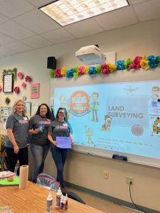
 What is Get Kids into Survey.
  -Intergeo 2023 was our teammate Paola’s FIRST event in the industry, we asked her how she found it:
 -What Does the Future Hold for Get Kids into Survey and the Industry as a Whole!
 Company Name –Maltby Land Surveys Ltd
Please fill out the form below to access our Translation Options Hotsheet:
A study on the students own living environment!
As said in this article by geografie.nl :What do young people think of their living environment?
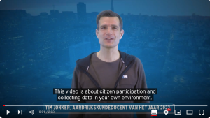
During the week of October 9 to 13, 2023, students aged 10 to 14 years old throughout the Netherlands will collect data about the playgrounds and hangouts in the neighborhood. This introduces them to topics such as citizen participation, geodata and living environment. By participating in this campaign, municipalities or neighborhood associations can take action to make the living environment more fun and beautiful for young people. The students not only experience that their input matters, they also learn to work with Geo-ICT. All they need is a working mobile phone. It fits well with various parts of the curriculum and digital literacy.Students spend approximately 30 minutes collecting the data and a maximum of 1 hour processing the data. Take a look at this YouTube video to learn more!
Netherlands National Youth Participation Campaign:
Inspection of playground and hangout spots- Students collect national data about the chill spots in the neighbourhood, so that the local municipality or neighbourhood association can take action to improve the living environment.
Inspection of playground and hangout spots- Students collect national data about the chill spots in the neighbourhood, so that the local municipality or neighbourhood association can take action to improve the living environment.
This practical assignment focuses on the theme of ‘involvement and participation’ and the influence you as a citizen can have on your own living environment. Nowadays, an aware and involved resident plays a crucial role in solving social issues. Involvement and awareness are the characteristics of our citizens that help us solve the problems of today and tomorrow sustainably.
Collect data yourself: VI Voluntary Geographic Information, also known as citizen science, is a form of citizen participation. It is the use of tools to create, collect and disseminate geographic data voluntarily provided by individuals in society. Learning to work with digital geographical technology Geo-ICT has now been included in the geography examination program and has therefore acquired a more important position in the school program in recent years. Learning to work with data collected by students themselves is a valuable addition to this. We see the “National Youth Participation Action” as a good investment in smart and involved citizens of the future.
Objectives Completing this assignment ensures that students…
1. look at their daily environment in an active, involved and critical manner.
2. collect their data in an online environment.
3. determine your position on the map.
4. realize that a ‘smart city’ does not exist without smart residents.
5. learn that they are an important part of society.
6. make a valuable contribution to our society.
7. contributing to solutions for social problems.
Instruction Telephone For collecting data, (at least) one telephone is required per group. To determine the location of the chill spot, positioning via the GPS of the phone is the easiest option. A major added value for the national campaign is that photos can be added to the data. Photos add a lot of information to the text and thus clarify the situation. In the context of the GDPR, the intention is that only the chill spot or parts thereof will be included on the map and not (fellow) students or other persons. It is up to the teacher to pay attention to this in advance and afterwards.
Processing of the results, depending on the level, available time and access to computers, different processing assignments and completion can be chosen. Class discussion to view the group’s results on a digital whiteboard. Evaluate the conduct of the inspection. ‘What did you think about it? Did it work well with the app? What did you notice during the inspections? Open the class dashboard and view the results. What stands out about the data? is the image positive, negative or very varied?’ View the photos of a number of chill spots and provide feedback on the inspection.Open the public dashboard and compare the results. Compare the data within a neighbourhood Compare the data within a district. Compare the data within a city Compare the data between cities and towns Compare the data nationally.
Joint action by experts from the KNAG, EduGIS, ESRI and Kadaster:
KNAG: The Royal Dutch Geographical Society is a society for all geographers in the Netherlands and for those who feel connected to the field of geography. The KNAG represents the interests of the discipline of geography and the school subject of geography. The KNAG is now concerned with the development of the subject of geography in education and seeks the connection between education, research, business and geography in practice. Furthermore, KNAG has the knowledge and experience of organizing national events for children (GeoWeek) and a broad network
KNAG: The Royal Dutch Geographical Society is a society for all geographers in the Netherlands and for those who feel connected to the field of geography. The KNAG represents the interests of the discipline of geography and the school subject of geography. The KNAG is now concerned with the development of the subject of geography in education and seeks the connection between education, research, business and geography in practice. Furthermore, KNAG has the knowledge and experience of organizing national events for children (GeoWeek) and a broad network
EduGIS: EduGIS is the platform for geo-related teaching materials to support teachers in the range from Primary to Secondary education (Lower, Middle and Upper School). EduGIS increases students’ awareness of the importance of spatial (read: geo) components (such as topography, land use, demography, etc.) in spatial social issues.
ESRI: Global market leader in geographic information systems technology: GIS. The vision of Esri Netherlands is: “We want to create a world in which everyone, every day, everywhere uses the power of geographic information. Esri Netherlands makes users of geo-information successful by using excellent GIS technology in a valuable way. to make.” As part of its work, Esri offers ArcGIS free of charge to all schools in the Netherlands.
Kadaster: Kadaster makes Geo-Information from various sources of government data usable for all customers and users and puts the user at the center so that everyone can combine information easily and reliably to answer questions, and everyone has insight into the quality of the information.