Please fill out the form below to download our Monopoly Sponsor Info Sheet Download:
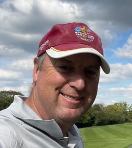
Introducing our latest Brand Ambassador John Fraser from Milton Keynes in the UK:
-
 What Brand Ambassador (BA) area are you covering? UK, Ireland, Benelux

Introducing our latest Brand Ambassador John Fraser from Milton Keynes in the UK:
 What Brand Ambassador (BA) area are you covering? UK, Ireland, Benelux
Introducing our latest sponsor who have the new Homework Project ‘Masters of Measures’, check it out!
Let’s learn some more about them:
 Company Name –
Our headquarters are in Vancouver, BC but we have 30+ offices across Western Canada!
As surveying has been a core McElhanney service since 1910, we have always been – and always will be – dedicated to advancing the industry and helping the next generation of surveying professionals flourish.
Everything in our built world – including the parks we play in, schools we study in, and paths we ride our bikes on – would be impossible without surveying. Surveyors are essential to developing vibrant communities, and we couldn’t build the places we call home without them!
And guess what? Surveying is also a fulfilling, fun, and outdoor-based career choice. We wanted to get involved in Get Kids into Survey because we want kids, teachers, and students to know about all the exciting career paths available in the industry. The world needs more surveyors!
I am a surveyor at McElhanney, which means I get to go to all sorts of wild places (sometimes back to my home swamp!) and play with wicked technology. At McElhanney, we provide geomatics, geospatial, GIS, engineering, environmental, planning, and landscape architecture services to clients across Western Canada and beyond. Me and my fellow McElhanney surveyors use all sorts of cool equipment like drones, laser scanners (ground-based and mobile), GPS, and total stations to collect and display our data in all sorts of ways: digital maps, plans, 3D models, and augmented reality models!
McElhanney’s roots go all the way back to 1910: we’ve been in the survey industry for over 110 years!
Growing up in my small home swamp, I knew I wanted to do something more with my life and sought out to find my purpose. Being so passionate about surveying, you would think that was the career I chose first. But no! I started out on a berry farm. Well, truthfully, they just hired me to stomp on the berries with my exceptionally large hooves to help make juice and jam!
While that job gave me a taste for working with my hooves in the outdoors, I felt like wanted to do something more. One day, a surveyor came to map out an area of the berry farm that had to be realigned, and they had so many cool gadgets that I just had to know more! Luckily, the surveyor was really friendly and spoke to me about how they got into surveying and where to start out.
I worked for McElhanney for a few years as a surveyor, starting out as an assistant and then becoming a junior technician. I went to university and then returned to McElhanney over my summer breaks until I got my degree! I’ve been with them ever since.
My legs are so long that I have my own custom-made tripods. It is often helpful that I am tall, because it means I get higher than some trees when we work further north, meaning I get a better signal with our GPS. I’m not quite as high up as the satellites that our GPS technology uses to calculate our position on the earth’s surface, but sometimes I feel like it! When I am working with other surveyors who are not moose like me, we have to set up our tripod low enough for them and I have to kneel down to see through the telescope. Luckily, we’re using laser scanning more and more now, which doesn’t require a telescope.
Gather ‘round, my forest explorers! Let me spin you a tale about old Spruce the Moose here, once named the Quirkiest Moose in all the Land! Now, you may think as a moose, I would spend my days munching on leaves and counting pinecones. But no! There is a lot more to me, you see. I have a secret – a love that runs deeper than the roots of a Spruce tree.
I’m sure you’d expect me to stick to the forest floors but let me tell you: I harbor a love for the subsea, and what’s my favorite aquatic sidekick? Sonars! These nifty gadgets go “ping” and echo, revealing all the mysteries hidden beneath the waves. Imagine me, the antlered adventurer, wearing moose-sized goggles diving into the ocean using my near X-ray vision to see for thousands of feet! With these sonars, I can help unravel the secrets and treasures the ocean floor loves to keep.
And that, my friends, is why I love sonars of all varieties. They’re not just a piece of my kit, but they’re a ticket to adventure, discovery, and a splash of underwater magic!
I have a real “hoof” of a time when I’m working on a survey that incorporates all of my skillsets, as the variety keeps my job interesting. However, when I get to fly our drones, I feel like a pilot!
Actually, I am a pilot, but only of small remotely piloted aircrafts. I wouldn’t trust me in a commercial plane, as I wouldn’t even fit in the cockpit with my antlers! So, I’d say that capturing LiDAR data from one of our multi-rotor drones is my favourite survey
Who are our Brand Ambassadors?
What does being a Brand Ambassador Involve?
What do you receive when you become a Brand Ambassador?
How do I become a Brand Ambassador?
Want access to our new Brand Ambassador Hub (with thanks to Topcon)?
All these questions are answered in the downloadable document below!
For further information please email erin@getkidsintosurvey.com
Or have a read and apply through the Brand Ambassador page.
Introducing our latest ambassador Mike Stewart who is from Utah area in the USA:
 Where did you study? Utah Valley University, Orem, Utah
What are the requirements to be a surveyor in your area? To be a surveyor in Utah, you need a combined 8 years worth of schooling and work experience. The good news is you can obtain them simultaneously. You also need to pass 2 national exams and the Utah state specific exam. For me, I obtained my bachelors degree in Geomatics and then had 4 years of work experience
How did you get into surveying? I was introduced to the idea of becoming a surveyor at age 20 by a future employer who was working as a civil engineer. I was exploring civil engineering at the time and when I met with this engineer he told me that if he could go back and do it all over again he’d be a surveyor. I asked him why, and he said that surveyors get to work inside and outside and are always working on different projects and are not confined to a desk every day. That peaked my interest and the more I looked into surveying the more I liked it and it didn’t take me long to fall in love with the profession.
How long have you been in the industry? I have been in the surveying industry since 2015.
Are you part of any associations or organizations you would like us to mention? I am a member of the Utah Council of Land Surveyors.
Why is it important for kids to know about surveying and the wider geospatial industry? Kids love technology and as a surveyor I get to use some the latest cutting-edge technologies in my work. Weather it’s a drone, a GPS, a LiDAR system, or a new computer program I get to combine state of the art technology with centuries old methodologies to do something I love. Beyond surveying, there are great careers in other related fields such as GIS (geographical information systems), Geodesy (the study of the shape of the earth and the math and science behind coordinate systems), Photogrammetry (creating high accuracy 3D models from images), and Remote Sensing (3D scanning via LiDAR, multispectral scanning, and raster image analyzation).
On top of all this cool tech, surveyors play a vital role in our society’s infrastructure. When a new road, building, house, etc… is going to be built, surveyors are called. When a property owner wants to know their property boundary, a surveyor is called. When land is going to be subdivide, combined, or adjusted, a surveyor is called.
What are you going to do as an ambassador for GKiS? What are your hobbies? As an ambassador for GKiS, I will be working with the local schools to help promote the great industry of surveying. I will be attending and helping with STEM fairs and Career Nights. My biggest hobbies and passions involve the outdoors. Weather that is hunting, fishing, backpacking, rock climbing, hiking, or exploring, I just love seeing the beaty of the land. I also enjoy playing sports and being active.
Anything else you want to add that you think our audience (surveyors, teachers, parents) would be interested in? In conclusion, surveying is a very old and well-respected industry. Traditionally, it may not have paid as much as its neighboring field of engineering. However, that is not the case anymore. Surveying has become a very well paid profession and for me is very satisfying and rewarding.
 Where did you study? Linn State Technical College
Educating kids about land surveying can open their eyes to the diverse career paths available within this field. From using advanced technology like drones and GPS equipment to working outdoors and collaborating with engineers and architects, land surveying offers a range of exciting opportunities. By highlighting the importance of accurate land measurements in construction, urban planning, environmental conservation, and more, we can inspire young minds to pursue licensure in land surveying and contribute to shaping the world around us.
I hope, by sharing my expertise and knowledge with youth to spark their interest in a field that is essential for infrastructure development and urban planning. Through hands-on demonstrations, I would like to show them how surveying techniques contribute to creating detailed maps, determining property boundaries, and ensuring the safe and efficient design of structures.
Land surveyors play a crucial role in the planning, design, and execution of various construction projects by accurately mapping out the land, determining boundaries, and collecting essential data for decision-making processes. Our expertise ensures that construction projects are carried out efficiently, safely, and in compliance with regulations. Without the valuable contributions of land surveyors, the successful completion of infrastructure projects would be significantly impeded. Recognizing and valuing the trade of surveying is essential for the continued progress and prosperity of societies worldwide.
Introducing our latest Ambassador Amy Johnson from Flower Mound, Texas, USA:
 What are the requirements to be a Surveyor in Texas? 4yr Education, FS and PS exam
Introducing Melvin Penwill covering the Midlands, UK:
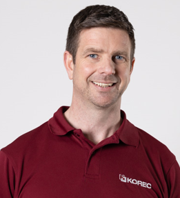 Where did you study? Nottingham Trent University
Get Kids into Survey Brand Ambassadors: Inspiring the next generation to see that our world is a playground, one adventure at a time!
A special thank you needs to be mentioned to Topcon for enabling the growth of our Brand Ambassador network. In 2024 we have introduced the Brand Ambassador Hub which allows everyone to stay connected as a community and puts all outreach resources in one place.
Let’s learn some more about why we created this initiative…
It’s our vision to ‘Inspire the next generation of surveyors’, which includes demonstrating to kids what our industry is all about…
To begin with children might find the elements of surveying interesting because it involves exploring and understanding the world around them in a hands-on way. Surveying includes using cool tools like maps, computers, and measuring instruments. It’s like going on a real-life treasure hunt where they get to discover hidden places, solve puzzles, and learn how things are connected. Plus, it taps into their natural curiosity by showing them how everything in their world fits together like pieces of a giant puzzle.
If you are thinking that the above information is accurate and great… BUT have no idea where to get started? That’s where we come in!
The role of GKiS is to create the resources (with the help of industry sponsors) that adults (surveyors/parents/teachers) can use to teach the kids about the geospatial industry. This enables surveyors to carry out the outreach with the materials that we provide, all for free as a voluntary basis.
We ask many of our Brand Ambassadors HOW they discovered the profession. To which many reply:
-’I fell into it’
-’my father/uncle was a surveyor and I liked it’
-’I applied for a trainee position as an adult and developed from there’
Can you imagine the amount of extra people that would love to be a surveyor… if only they had heard of the job when they were growing up!?!
By teaching young people about surveying, through fun resources, this will make them aware of what a surveyor is. By bringing awareness to the industry that will create curiosity for the kids to go on to learn more about the industry (and potentially enter into it when they are older).
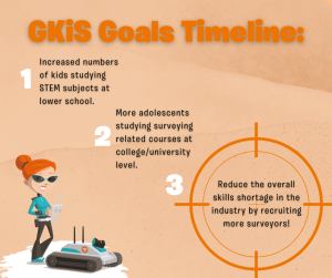
Let’s look at the timeline:
-have more kids studying STEM at lower school.
-have more adolescents study geomatics related courses at college/university level.
-reduce the overall skills shortage in the industry by recruiting more surveyors.
Get Kids into Survey help this movement through our volunteer Brand Ambassadors. Our Brand Ambassadors have a passion for their jobs and the industry they work in… ready to spread the word throughout their local area!
By becoming a brand ambassador for Get Kids into Survey you’ll empower individuals to be catalysts for curiosity and learning in the younger generation. By promoting the exciting world of surveying, ambassadors contribute to inspiring kids to explore and understand their surroundings. This role not only fosters a sense of adventure and discovery but also plays a vital part in shaping the future by encouraging children to engage with STEM (Science, Technology, Engineering, and Mathematics) fields, promoting critical thinking, and fostering a love for exploration and problem-solving from an early age.
What do you get as a Brand Ambassador?
-Access to an expanding collection of outreach materials
-Be a part of the Brand Ambassador community Hub with thanks to Topcon
-Have your own profile on the global website, with a map point linking to it.
-Chance to grow your connections and personal brand
-Knowledge that you are directly helping to support the future of the industry!
What are the expectations of a Brand Ambassador?
-We require the applicant to have a passion for the industry with a shared vision to ‘get kids into survey’.
-Have some availability to designate towards going into their local community… Whether that be to do a talk with a group of students, or just to distribute some posters around a couple of schools would be great.
-Be active on the Brand Ambassador hub by interacting with other ambassadors and sharing your outreach efforts.
-Be active on social media by liking the odd post, shares are very much appreciated too in order to spread the word around multiple connections.
How can you apply to be a Brand Ambassador?
Our application process has been simplified so you can enter your profile photos and profile information to the online form here.
This means we can review your application, invite you to the hub, add you to the comms list, and have your profile up on the website within days!
So… what are you waiting for?
Any extra questions or if anyone is struggling to apply please let us know at erin@getkidsintosurvey.com