Welcoming Brand Ambassador Simon Leeming from the Midlands, UK:
How did you get into surveying?
Apprentice Surveyor in 1995-2000, became Chartered through RICS
Why are you volunteering as a Brand Ambassador?
Want to get kids as passionate about surveying as I am – fantastic career. I am also a STEM ambassador in the UK with Minerals Matters.
Tell us about what you do:
I manage the Surveying function that covered 5 underground gypsum mines and 1 surface quarry. I also manage the estates work across 6 plants and a dozen or more legacy mines. Use traditional theodolites, laser LiDAR scanners, Drones, Photogrammetry and more
Ambassador Spotlight ‘Filipe Sousa’
Welcoming Filipe Sousa our latest Brand Ambassador from Canterbury, New Zealand:
How did you get into surveying?
I started as a Survey Assistant in 2015 working with underground cables as-built surveys. Slowly got trained on the job and became a little confident with all the toys: Digital Levels, GNSSs, Total Stations, UAVs and Laser Scanners. I have been surveying out and about since then.
I have no formal education degree in the geospatial field. I am actually a Biologist by degree, but learnt the joys of surveying thanks to the training all the colleagues and leaders gave me on the jobs.
What are your plans as an ambassador?
I want to take what we do (Surveying) to everywhere we would be welcome. Schools, universities, polytechnics, and/or any other relevant events such as fairs, conferences etc.
Tell us about what you do
Currently working on Land Development projects, with the private and public sector. We get involved from the Topographical Survey of the site all the way to delivering the keys to the new tenants/owners. This involves all the legalities of subdividing the land, and the field work too. Boundary definitions, building set-outs, building location certificates, as-built surveys etc.
Ambassador Spotlight ‘Ian Stephens’
Introducing Ian Stephens our latest Brand Ambassador who is covering the Midlands area of the UK:
Where did you study?
I learned on the job and completed a 3 year training programme. I’ve since completed QCF Level 6 Diploma in Utility Mapping and Surveying in my spare time.
Requirements to be a Surveyor in your area:
We don’t ask for much other than the willingness to work hard, travel, stay away from home and the desire to progress and develop.
How long have you been in the industry?
19 years
How did you get into surveying?
I’d been made redundant and saw an advert in my local newspaper for a trainee.
Any associations and organisations you’d like to mention?
I’m in the process of joining the Chartered Institution of Civil Engineering Surveyors (CICES) through our Company’s Approved Development Scheme.
Why are you volunteering as a Brand Ambassador?
I worked my way through my career from complete novice with no formal training and we do the same with the trainees we employ. I enjoy working with trainees and want people to experience what I have with my career.
Why is GKiS important?
Growing up and until I found the job advert, I had no idea surveying existed. The industry needs young people for it to thrive in the future and I believe it’s a truly amazing career with many great opportunities.
What are your plans as a BA?
I’d like to engage with local schools and colleges, university career fairs and other events to speak to young people and share my passion for the industry.
What are your hobbies?
I enjoy running as a way to switch off. I’m passionate about Formula 1 too.
GKiS character ideas:
I always pictured our avatar as something like a Lion which is a strong leader.
GKiS resources ideas:
I think online resources are important as younger people engage more with these. Something like site walk throughs or some simple modelling tasks/games. I also think awareness of GKiS needs to increase as a whole.
Anything else you’d like to add?
Our industry is extremely fun to be in and once involved, you quickly become attached and would never imagine doing anything else. The industry is full of respected experts and has a sense of community where everyone shares ideas, tips and technology. There simply isn’t any other like it!
Ambassador Spotlight ‘Joseph Phil’
Introducing Joseph Phil our latest Brand Ambassador from New Jersey, USA. Let’s learn some more about him:
How did you get into surveying?
I got into the Geospatial Industry shortly after joining my current firm as a civil engineer graduate, I was presented an opportunity and path to further my education and ultimate licensure as a Professional Land Surveyor. To say it was a great decision would be an understatement, there is so much to learn and appreciate while being able to utilise some really cool technology each and every day!
Why are you volunteering?
This field has so many opportunities for career growth and there is really something for everyone whether they like math, history, reading, writing, the outdoors, computers, technology, drones, etc. The message is simple, and I couldn’t agree more with the mission of GKiS because they are the future!
What are your plans as an ambassador?
I plan to volunteer my time to participate in various outreach programs such as conferences, schools, events, etc. promoting the land surveying / geospatial industry. I was lucky enough to get into this as a career and now is the time to pay it forward.
Tell us about what you do:
I am currently a Principal and the Land Survey Department Manager at Suburban Consulting Engineers, Inc. for which I have the pleasure to work with an incredibly talented staff that is focused on our day-to-day projects preparing various survey and maps. Each project is exciting but can have its fair share of challenges that allows us to work together as a team coming up with solutions. It is always rewarding to see the finished product and I’m consistently proud to sign each and every survey we prepare!
Remote Sensing Hub by Minesat
Recently, it has become clear that many of us in the geospatial industry share a common goal: raising awareness of our field. This need is even more pressing now, as companies are starting to recognise the challenges posed by the low enrollment rates in geospatial programs at colleges and universities, making it difficult to find top talent at career level.
At GeoBusiness in June Erin was introduced to Gideon from Minesat. Minesat is on a mission to democratise remote sensing!
What is remote sensing?
Remote sensing is the capture of information from a distance using onboard sensors (passive or active) deployed in satellites, drones, planes, helicopters and survey equipment. It detects and measures reflected or emitted energy of physical objects on the earth, everything from light and sound to electrical, chemical and magnetic.
Data can be combined with advanced technologies such as AI, GIS, BIM and Analytics for decision-making across industry and research. For instance, communication networks (your pilot uses satellite signals to guide you safely home), infrastructure (digital twins use light imaging from drones or ground laser scanning) or urban planning (satellites can identify heat islands to inform policy).
We love that Minesat shares a large educational hub, in which Get Kids into Survey now features (in the ‘Ground’, ‘GNSS’ section)!
Let’s hear more from the Founder, Gideon Simons about the project:
“We are seeking to build a community connecting people with the whole spectrum of remote sensing and advanced technologies and advocating their uses for the betterment of society.
Our vision is to make this more accessible in terms of knowledge, education and use as we are realising their combined potential to solve many of the challenges we face as a society, from climate to resources to urbanisation.
We are doing this through sharing best practices, experiences and ideas from industry, non-profit and educational bodies. In doing so we foster partnerships that improve accessibility and inclusivity with the aim to accelerate the uptake of technology in industry, enabling non-profits to deliver more value and support educational opportunities for our younger generations.
As such, we are excited to work with our new partner Get Kids into Survey with this last objective in mind: providing educational resources to kids in primary and middle school so that they can experience and understand the technology and their fantastic applications in our world. Ultimately, to give more children a more informed choice about how they can support our future.
We are providing links to all of GKiS content as we think it’s a great resource for kids – we also have more content around survey if they want to dive in further plus a whole host of content on drones, advanced air mobility and space and satellites.
Do come and visit us, have a look and join up for more resources coming soon!”
Character Spotlight ‘CEC’
Introducing our latest brand sponsor as seen in the Surveying in Space poster, it’s Civil & Environmental Consultants, Inc. (CEC). Let’s learn some more about them:
1. Company Name – Civil & Environmental Consultants, Inc. (CEC)
2. Location – Headquartered in Pittsburgh, PA with 34 offices across the U.S.
3. Why is it important for your company to help Get Kids into Survey? – The Surveying and Geospatial Profession is an exciting career for kids to consider, because it combines what so many of them love to do.If a kid finds himself not being able to decide between playing video games and playing outside, Surveying gives them the opportunity for “hands-on” technology and exploring the physical world around them!We want to inspire Kids to consider a life as a Professional Land Surveyor or a Geospatial Professional.
4. What do you do? I am the Corporate Survey / Geospatial Practice Lead, which means I am the company “cheerleader” for about 40 Professional Land Surveyors and 195+ Survey Staff members located in 22 of our offices.What CEC “does” ranges from topographic surveys where we map the surface of property on-the-ground and using UAV “drones” for design and development, to ALTA Surveys used for the sale of commercial or industrial properties, to Solar development where we survey for design and layout the solar panels and other improvements, we measure for roadways, pipelines, buildings, utilities.We use mobile LiDAR, terrestrial LiDAR, we have 40+ UAV pilots and craft, we also use hydrographic equipment to measure the bottoms of rivers, creeks, and lakes and geophysical / utility locating equipment to measure underground utilities and structures.You name it, we measure it!
5. How long have you been in the survey industry? – I have been surveying since the Chicago Bears won the Superbowl … about 39 years (I’m originally from the Chicagoland area and move to Pittsburgh to join CEC almost 10 years ago).CEC has been providing surveying services for about 25 years.
6. How did you end up getting into the geospatial industry? I took a sabbatical from college, wanted to get a job and saw an advertisement in a newspaper that said, “Land Surveying crew member, no experience necessary”.I didn’t know what “Land Surveying” was, I thought I would go door-to-door asking people questions about their land!My first day on the job I spent walking through the woods measuring trees on a beautiful fall day … I thought “I can’t believe they are actually going to pay me to do this”!I have been surveying ever since.CEC originally got into surveying to provide existing conditions surveys for civil engineering design and landfills.It has since grown to be an independent practice, the second largest in the company!
7. State a funny fact about you… I have 12 kids, a very patient and loving wife, and 3 of my kids are in the surveying profession (so far)!I am also in two bands that are made up of instrument-playing land surveyors that only exist to play at two survey conferences.The Illinois (IPLSA) conference band is “Monuments Men”, the Pennsylvania (PSLS) conference band is “Plumb Bob and the Chaining Pins”.
8. Favourite piece of kit and why? I still miss my old orange Geodimeter 600 series robotic total station I used back in my field days!Not the easiest equipment to use, but rock solid, accurate, and very reliable!Also, I still have my original plumb-bob that my first boss gave to me … most people in surveying don’t even know what a plumb-bob is!
9. Favourite Survey technique and why? I am most excited by our LiDAR equipped UAV systems, because they are a “game changer” in mapping, but you still need the basics of good ground control to make sure the map matches “reality”.I don’t personally fly UAV’s … my kids have seen me playing video games and can attest I am not an expert with a joystick!
11.How did you choose the character and what does he/she/it represent? Mean to you? What’s his/her name? I thought an image of a “robotic surveyor” would capture the technology with the physical realism of surveying.I named the character “CybErC”, after CEC’s intranet program, which is the “hub” for standards, and both company and project information for CEC staff.Just like in many ways “Survey / Geospatial” is the “hub” for so many of the other services we offer.
Character Spotlight ‘Emesent’
Introducing our wonderful new sponsors Emesent who have been heavily involved with the Space poster providing extra prints for Australia! Let’s learn some more about them:
Company Name Emesent
Location Brisbane, Australia
Why is it important for your company to help Get Kids into Survey?
Surveying is essential to so many parts of our world and impacts many industries, often in ways that most people don’t fully appreciate. There is a diverse range of surveying jobs that cross many different skills and work environments. We believe that encouraging the next generation of surveyors is critical to our future, both in Australia and globally. Educating young people about the power of surveying, the incredible technology available, and the different ways surveying is used, will contribute to the enhancement of our world.
What do you do?
Emesent makes an advanced LiDAR (Light detection and ranging) scanner called Hovermap that helps surveyors autonomously map difficult-to-access environments. Hovermap captures detailed 3D maps called point clouds. Point clouds can be used by surveyors in construction, mining, forestry and many other industries – even space! – to better understand and then make decisions about the environments they are working in.
How long have you been in the survey industry?
Emesent was founded in 2017
State a funny fact about you…
Emesent staff where once invited to appear on a ghost hunting TV show to use Hovermap to see if we could identify a ghost!
Favourite piece of kit and why?
Emesent Hovermap ST-X is of course our favourite piece of kit. As well as using it hand-held, you can attach it to a car, robot or drone. It has a variety of accessories that can be attached to it also.
Favourite Survey technique and why?
Flying Hovermap on a drone is our favourite way to capture survey data. But anyone can get started by using Hovermap handheld or in a backpack.
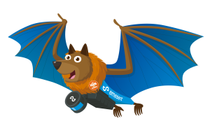
How did you choose the character and what does he/she/it represent? Mean to you? What’s his/her name?
This is Billie the Hover-Bat. The character is inspired by a local ‘bat’ called a flying fox. In summer, these animals go looking for fruit and berries, flying across the sky at dawn and dusk. We chose it because Hovermap is commonly flown on a drone – often underground into inaccessible and dark spaces.
Ambassador Spotlight ‘Victor Okonkwo’
Introducing Victor Okonkwo from the Anambra State, Nigeria, Africa as one of our latest Brand Ambassadors! Let’s learn some more about him:
First, you’ll need a bachelor’s degree.
Second, you’ll need to apply to become a pupil surveyor, and after your application is accepted, you’ll serve as a pupil surveyor under a registered surveyor for 2 years minimum.
Third, after your 2 year pupilage is up, you then apply to become a registered land surveyor.
Note: You would be registered as a land surveyor by the surveyors council of Nigeria after having fulfilled requirements such as: preparing a survey folio reporting a total of 5 projects carried out and completed within your pupilage years, preparing for a written exam and also an interview where you need to defend the contents of your survey folio.
How long have you been in the industry?
Since 2011, after I graduated highschool
How did you get into surveying?
I never wanted to become a surveyor. I saw myself in the profession. But from my first day in the field with a surveyor, watching him carrying out a survey like a director would direct an orchestra, I knew that I wanted to become one.
Any associations and organisations you’d like to mention:
Nigerian Institute of Surveyors (NIS)
Young Surveyors Network (YSN)
Why are you volunteering?
Surveying is a dying profession; this is what I have come to observe and the only way to save it is to introduce the profession to kids. Not just introduce it to them, but make it something they would feel the need to be a part of. I am volunteering to preserve the profession, to make surveying a household name like medicine or engineering, to make kids and parents alike see an importance in the profesion and it’s professionals.
Why is GKiS important?
Because it is the bedrock of any meaningful development. Without surveyors, the architects, engineers, builders, cannot begin a project. Children need to understand that surveying is everywhere. We are the planners of modern society.
What are your plans as a Brand Ambassador?
The most important thing I’d do is to raise the banner of GKis high in my city, Awka. Create thorough awareness about GKis and then “invade” institutions of learning to meet with our target audiences.
What are your hobbies?
Chess, swimming, writing poetry and short stories, and listening to classical music.
Any GKiS character ideas
A lion’s cub
Ideas of future GKiS resources:
How to use technology to get kids into surveying via AI, Virtual reality, Games etc
We use cookies on our website to give you the most relevant experience by remembering your preferences and repeat visits. Read More.
This website uses cookies to improve your experience while you navigate through the website. Out of these, the cookies that are categorized as necessary are stored on your browser as they are essential for the working of basic functionalities of the website. We also use third-party cookies that help us analyze and understand how you use this website. These cookies will be stored in your browser only with your consent. You also have the option to opt-out of these cookies. But opting out of some of these cookies may affect your browsing experience.
Necessary cookies are absolutely essential for the website to function properly. This category only includes cookies that ensures basic functionalities and security features of the website. These cookies do not store any personal information.
Any cookies that may not be particularly necessary for the website to function and is used specifically to collect user personal data via analytics, ads, other embedded contents are termed as non-necessary cookies. It is mandatory to procure user consent prior to running these cookies on your website.
Translation Options Hotsheet Download
Please fill out the form below to access our Translation Options Hotsheet:
Monopoly Sponsor Info Sheet Download
Please fill out the form below to download our Monopoly Sponsor Info Sheet Download:
Autumn Poster Hotsheet Download
Please fill out the form below to access our Poster Hotsheet:
Summer Poster Hotsheet Download
Please fill out the form below to access our Poster Hotsheet:
Spring Poster Hotsheet Download
Please fill out the form below to access our Poster Hotsheet:
Poster Hotsheet Download
Please fill out the form below to access our Poster Hotsheet:
Re-Print Hotsheet Download
Please fill out the form below to access our Re-print Hotsheet:
Winter Poster Hotsheet Download
Please fill out the form below to access our Poster Hotsheet:
Homework Project Info Pack
Please fill out the form below to access our Homework Project Information Pack:

 How did you get into surveying?
 Where did you study?
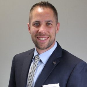 How did you get into surveying?
 1.
1.  Company Name Emesent
 Where did you study?
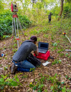 Why is GKiS important?
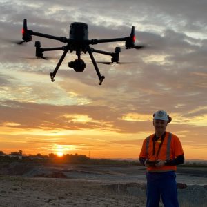 How did you get into surveying?