Ambassador Spotlight ‘Claire Fenwick’

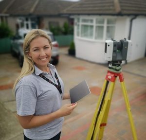
Welcoming our latest Brand Ambassador Claire Fenwick covering London and surrounding areas of the United Kingdom. Let’s learn some more about her:

How did you get into the geospatial industry? After studying for a BA Honours degree in Graphic Design at University for the Creative Arts, I decided to change career completely. Geomatics surveyors work outdoors, and the role offers considerable opportunities for travel which also appealed to me!

At the age of 23, I chose to retrain as a Geomatics Surveyor at The Survey School offered by The Survey Association (TSA). After graduating I progressed from a Trainee Surveyor to Senior Surveyor. I founded Spatial Dimensions in 2012 and have seen the company grow into a national company since then!

Tell us a bit about what you do?Anything else you want to add that you think our audience (surveyors, teachers, parents) would be interested in? I’m the Managing Director of Spatial Dimensions (https://spatial-dimensions.co.uk/), and the President of The Survey Association (https://www.tsa-uk.org.uk/).

Both roles come with their unique challenges and opportunities.

As Managing Director of Spatial Dimensions I run the daily operations of the company. This includes everything from advising on large scale survey projects, to the hiring of staff!

As TSA President I strongly believe in the benefits of sharing knowledge and upholding standards within our profession. I also actively promote careers in the built environment for women, trying to address the gender imbalance and skills shortage in the geospatial profession.

What are your plans as an ambassador? School and university outreach is something I truely believe in, and love doing! As an ambassador I’d love to play a key role in offering surveying as a viable career option.

I think it’s important to use connections and platforms to spread the message, too. This is something I’d love to utilise!

One of our key missions at The Survey Association is “every young person should know about land surveying as a career”; This is something that directly aligns to Get Kids Into Surveying!

Anything else you want to add that you think our audience (surveyors, teachers, parents) would be interested in? At the end of 2024, Spatial Dimensions launched a YouTube channel which looks at various aspects of surveying. Please see our latest video on defining level of detail (LOD) here: https://youtu.be/A9Savf24EuI

For teachers, parents and potential new geospatial surveyors, please visit, www.becomeasurveyor.com


Ambassador Spotlight ‘Charlie Minshaw’

Welcoming our latest Brand Ambassador Charlie Minshaw from the North East in the UK:

How did you get into surveying? Masters degree in Civil Engineering, daily duties setting out and surveying as a Site Engineer.

What are your plans as a Brand Ambassador? Promote the role/industry in schools/colleges, working alongside my other duties as a STEM Ambassador and my companies Social Value/Community Enhancement work engaging with young people and community stakeholders.

Tell us a bit about what you do? Setting out and surveying in the Railway industry, currently working on construction of 6 new stations. Working for a principle contractor managing different areas of work, production of as-built records and verifying construction works by subcontractors.

Anything else that you’d like to add? My role also promotes sustainability and has a strong emphasis on community relations and stakeholder engagement, so I have a strong network to work with when branching into other topics relating to this sector.

Ambassador Spotlight ‘Salman Ibrahim’

Welcoming Salmon Ibrahim our latest Brand Ambassador covering Houston, Texas, USA:

How did you get into surveying? I have been a professional for more than 14 years

What are your plans as a Brand Ambassador? I am excited to become Brand Ambassador and promote it on my social media pages to get kids and youth more awareness about surveying industry and to become surveyor

Anything else you’d like to add? I am excited to become Brand Ambassador and promote it on my social media pages to get kids and youth more awareness about surveying industry and to become surveyor

Ambassador Spotlight ‘Chris Jepson’

Introducing Brand Ambassador Chris Jepson from Washington, USA:

How did you get into surveying? I’m the son of a Surveyor

What are your plans as a Brand Ambassador? To continue developing statewide Outreach efforts.

Tell us a bit about what you do? I work with an effective team of surveyors to make great maps!

Anything else you’d like to mention? Past President of the Land Surveyors’ Association of Washington -2022

Current Outreach Committee Chair

Ambassador Spotlight ‘Svetlana Klockova’

Welcoming Brand Ambassador Svetlana Klockova from Hampshire, UK:

How did you get into surveying? When I moved to the UK in 2017 my first neighbours were ocean exploration students. We spent a lot of time hanging out together and it gave me an opportunity to learn about surveying/hydrography. Less than a year into our friendship I decided that I want to work offshore as a surveyor. This completely random friendship provided me with a career I love.

What are your plans as a Brand Ambassador? I am working on creating media content that will help kids to visualise what we are doing offshore. I believe description along with picture/video will make them more curious about offshore surveying. Also I hope they will think it is a cool job to do.

Tell us a bit about what you do? I am an Offshore surveyor working in oil and gas, and renewables industry. My primary duties involve providing subsea position mainly to ROV, conducting geophysical surveys and making sure we are working in the right geodesy.

Character Spotlight ‘CLSA’

Introducing: The “Grizz” by California Land Surveyors Association (CLSA)

The newest member to the Get Kids into Survey family, representing:

  1. Company Name – California Land Surveyors Association (CLSA)
  2. Location – Sacramento, California – The heart of the land survey world, in my opinion!
  3. Why is it important for your company to help Get Kids into Survey? Because the world needs more explorers, innovators, and mapmakers! Surveying combines the spirit of adventure with cutting-edge tech, offering kids a career that’s as rewarding as it is exciting. Plus, who doesn’t want to measure up to greatness?
  4. What do you do? We help surveyors stay sharp, stay informed, and stay connected. From legislative advocacy to education and professional growth, we ensure surveyors across California are always at their best—whether they’re mapping cities or conserving nature.
  5. How long have you been in the survey industry? Let’s just say we’ve been holding the line (and leveling it!) for almost 60 years.
  6. How did you end up getting into the geospatial industry? We were lured in by the perfect combination of technology, the outdoors, and problem-solving. Surveying isn’t just a job—it’s a treasure hunt where every map is a victory!
  7. State a funny fact about you: “They” say I’m extinct, but clearly, they haven’t seen me hitting the trails or double-checking boundary lines. I’m the life of the topo party!
  8. Favorite piece of kit and why? Drones, because who doesn’t love flying high while getting the lay of the land? With a bird’s-eye view and high-tech sensors, drones make surveying smarter, faster, and way cooler.
  9. Favorite Survey technique and why? The SLAM (Simultaneous Localization and Mapping) It’s like magic! Grizz loves how SLAM turns tricky terrain into digital masterpieces in real-time, making him the king of the (data) forest.
  10. Your website
  11. How did you choose the character and what does he/she/it represent? Mean to you? What’s his/her name?

Grizz was inspired by California’s iconic Grizzly Bear, a symbol of strength, exploration, and resilience.

  • What does Grizz mean to you?

Grizz is the ultimate field companion, blending California’s wild spirit with the precision and creativity of surveying. He’s the bear who proves that surveying is bear-y exciting!

  • What’s his/her name?

Grizz, it’s short, memorable, and packed with character (just like a perfectly mapped plat!).

  • More about Grizz:

Grizz is the last of the legendary California Grizzlies, and while most think he’s retired, he’s thriving in the surveying world. When he’s not measuring parcels or chasing coordinates, you’ll find him climbing the Sierra Nevada’s, chilling by Lake Tahoe, shredding the gnar, or dropping wisdom at land surveying workshops.

Character Spotlight ‘SAM’

Introducing SAM and their latest character of Bella. All questions are answered by SAM’s Vice President / Mountain Area Director – Tyler Trujillo. Let’s learn some more about them:

  1. Company Name – Surveying And Mapping, LLC (SAM)
  2. Location – Utah Office (Nationwide Firm)
  3. Why is it important for your company to help Get Kids into Survey? Surveying is one of the world’s oldest professions, and its future is brighter than ever! It’s a career that blends science, technology, engineering, and mathematics (STEM) with hands-on, real-world applications, offering kids an exciting mix of adventure and innovation. Today’s surveyors use cutting-edge tools like drones, GPS systems, and 3D mapping technology while working outdoors to explore and shape the environment. With many experienced professionals preparing to retire, there’s a huge opportunity for the next generation to step into this vital field. Introducing kids to surveying early helps them develop critical skills like problem-solving and teamwork while setting them on a path to a stable and rewarding career that has a lasting impact on the world.
  4. What do you do? We are the nation’s largest Managed Geospatial Services™ (MGS™) company, offering Aerial Mapping, Geomatics, Utility Engineering, BIM, GIS, and Engineering Inspection Services across various infrastructure markets.
  5. How long have you been in the survey industry? Personally, been in the industry for 22 years, and working as the Mountain Area Director for SAM who has been in business for over 30 years.
  6. How did you end up getting into the geospatial industry? Had never heard of surveying all throughout school, and had a college program for aviation get canceled during the senior year of high school. A friend of mines Grandfather was a cadastral surveyor for Utah BLM and asked if I would be interested in a summer internship. After spending the summer in the Utah wilderness using GPS and hiking to original corner locations, I found what I wanted to do for my career.
  7. What is your characters favorite subject in School: Definitely Mathematics
  8. Favorite piece of kit and why? A Compass and a Quad Map, it’s the basics of which I learned to navigate in the wilderness during retracement surveys out west. In addition, whenever Bella encounters a compass, she states “that’s what dad does for work”…
  9. Favorite Survey technique and why? GPS data collection – I find it fascinating how accurate, reliable, and repeatable ground positions can be, by collecting data from instruments orbiting earth thousands of miles away.
  10. Your website
  11. How did you choose the character and what does he/she/it represent? Mean to you? What’s his/her name? Character’s name is Bella and represents my youngest daughter. I felt it was an opportunity to introduce her to more of the surveying profession as a middle schooler, and she thought it would be cool to be part of the program and have her own GKiS avatar!


Character Spotlight ‘Elevated Land Surveying’

Welcoming Elevated Land Surveying, our latest brand sponsors! They will be appearing in West Coast Get Kids into Survey’s upcoming poster… Let’s learn a bit about them:

Company Name:
Elevated Land Surveying

Location:
Idaho Falls, Idaho, USA

Why is it important for your company to help Get Kids into Survey?
At Elevated Land Surveying, we recognize the importance of inspiring the next generation to explore the land surveying profession. By engaging with young minds, we aim to foster an appreciation for the critical role surveying plays in shaping our communities and infrastructure. Introducing kids to this field can ignite a passion for STEM subjects and ensure the continued growth and innovation of the land surveying industry.

What do you do?
We are a full-service land surveying company offering a comprehensive range of services, including boundary surveys, topographic mapping, construction staking, and ALTA/NSPS Land Title Surveys. Our experienced and licensed surveyor, equipped with cutting-edge technology, ensures precise results for large-scale developments or individual property needs. 

How long have you been in the survey industry?
We have been in the land surveying industry for 9 years, delivering reliable and accurate services to clients throughout Idaho, Utah, Nevada, and Colorado.

How did you end up getting into the land surveying industry?
The journey into the land surveying industry began with enrolling in an engineering program, where exposure to surveying techniques and tools sparked a strong interest in the field. During this time, I discovered the unique combination of working outdoors, utilizing advanced technology, and solving real-world problems that surveying offers. What started as a focus on engineering quickly evolved into a passion for land surveying, driven by a fascination with maps, spatial relationships, and contributing to meaningful projects. Elevated Land Surveying was established to turn that passion into a profession that makes a tangible difference in our community.

Favorite piece of kit and why?
Our favorite piece of kit is the robotic total station. It’s a game-changer for modern surveying, allowing for precise measurements while enabling single-person operation. The robotic total station significantly improves efficiency, especially on larger or more complex sites, by automatically tracking the prism and communicating data in real-time. It’s all about the precision, and this tool delivers the accuracy we need to ensure our work is reliable and meets the highest standards. Its versatility and ease of use make it an indispensable part of our workflow, helping us provide top-quality results to our clients

Favorite Survey technique and why?
Our favorite survey technique is boundary surveys. They are the cornerstone of land surveying, providing clarity and certainty about property lines and ownership. Each boundary is like a puzzle, completely unique, requiring us to piece together historical records, legal descriptions, and physical evidence to uncover the full picture. This individuality makes every project a new challenge, keeping the work both exciting and rewarding.

Your website

How did you choose the character, and what does he/she/it represent? What’s his/her name?
We selected our character, “Eli the Elk.” The elk symbolizes strength, precision, adaptability, and majesty—qualities we embody in our work. Eli reflects our ability to navigate challenging terrains with care and precision, just as an elk majestically moves through the wild. He represents our commitment to delivering reliable, precise results in every survey.