
Introducing our latest sponsors the Faculty of Civil and Geodetic Engineering at the University of Ljubljana! We are super thankful to the team here who have helped to translate 2 of the geospatial posters (with Q&A sheets) into Slovenian, ready to print and distribute around Slovenia.
Let’s learn some more about them:
 1. Company Name –
Faculty of Civil and Geodetic Engineering, University of Ljubljana
2. Location –
Ljubljana, Slovenia
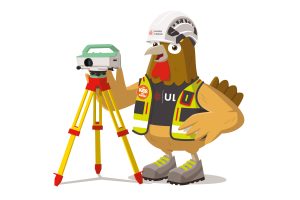
3. How did you choose the character and what does he/she/it represent? Mean to you? What’s his/her name?
I am hen Slavi. In shape, I resemble the outline of our country, Slovenia, with the head on the left and Slovenia on the right. I use high-quality personal protective equipment to ensure the safety and health of employees. Primarily, I assist geodesists and builders from the Faculty of Civil and Geodetic Engineering at the University of Ljubljana in building a sustainable future.
4. Why is it important for your company to help Get Kids into Survey?
Our faculty is the only one in Slovenia offering study programs in geodesy and geoinformatics. We aim to attract more students to these programs because we believe that too many children are unaware of this profession and its fascinating nature.
5. What do you do?
Our primary activity is educating students to become professional geodesists with university qualifications. However, we also engage in other enjoyable activities. We research and test new methods in measuring and presenting spatial data, conduct field measurements of challenging engineering structures such as tunnels and large hydroelectric power plants, and organize excursions worldwide with students to learn new things.
6. How long have you been in the survey industry?
The University of Ljubljana was founded over 100 years ago in 1919. From the beginning, alongside the legal, philosophical, medical, and theological faculties, it had a technical faculty where geodesy was taught.
7. How did you end up getting into the geospatial industry?
Geodesy is one of the oldest sciences globally, with ancient Greek mathematicians already involved in calculating the size and shape of the Earth. Geodesy has been a major discipline taught at the University of Ljubljana since its establishment.
8. State a funny fact about you…
When Yugoslavia dissolved in 1991 and a new country, Slovenia, was formed, they decided its shape would be that of a hen, just like me: https://www.google.com/maps/place/Slovenija/ The last leg touches the sea, the tail features beautiful mountains, and the head lies in the Pannonian Plains.
9. Favourite piece of kit and why?
My favourite tool is the level. It’s the simplest of geodetic instruments but allows for the most precise measurements of height differences. With it, I can determine the elevations of mountain peaks or measure where a river has enough drop for a new hydroelectric power plant.
10. Favourite Survey technique and why?
Of all geodetic measurements, I enjoy working with drones the most. From aerial photographs, I can create beautiful 3D representations of historical objects or assist builders during excavations, foresters in measuring forest growth, and geodesists in drawing new maps.
11. Your website.